Powell River elevation
Powell River (British Columbia, Powell River Regional District), Canada elevation is 41 meters and Powell River elevation in feet is 135 ft above sea level [src 1]. Powell River is a populated place (feature code) with elevation that is 217 meters (712 ft) smaller than average city elevation in Canada.
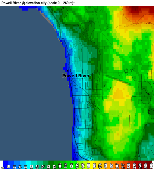
Below is the Elevation map of Powell River, which displays elevation range with different colors. Scale of the first map is from 0 to 269 m (0 to 883 ft) with average elevation of 107.3 meters (=352 ft) [note 1]
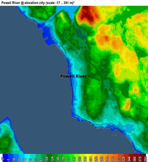
These maps also provides idea of topography and contour of this city, they are displayed at different zoom levels. More info about maps, scale and edge coordinates you can find below images.
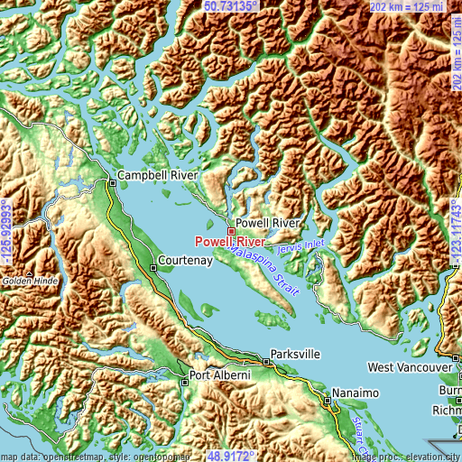
| \ | Map #1 | Map #2 | Topo.Map |
| Scale [m] | 0..269 m | -17..391 m | × |
| Scale [ft] | 0..883 ft | -56..1283 ft | × |
| Average | 107.3 m = 352 ft | 141.8 m = 465 ft | × |
| Width | 6.3 km = 3.9 mi | 12.61 km = 7.8 mi | 201.7 km = 125.3 mi |
| Height | 6.3 km = 3.9 mi | 12.61 km = 7.8 mi | 201.7 km = 125.3 mi |
| ↑Max Latitude | 49.861117° | 49.889438° | 50.73135° |
| Latitude at center | 49.83278° | 49.83278° | 49.83278° |
| ↓Min Latitude | 49.804426° | 49.776056° | 48.9172° |
| ← Min Longitude | -124.567625° | -124.611571° | -125.92993° |
| Longitude center | -124.52368° | -124.52368° | -124.52368° |
| →Max Longitude | -124.479735° | -124.435789° | -123.11743° |
Nearby cities:
Cities around Powell River sort by population:
• Campbell River elevation 65 m
55.5 km,  291°
291°
• Courtenay 13 m
37.5 km,  244°
244°
• Parksville 26 m
59 km,  165°
165°
• Cumberland 165 m
44 km, 236°
• Royston 9 m
36.7 km, 235°
• Coombs 118 m
59.8 km, 172°
• Puntledge 108 m
42.8 km, 243°
• South Pender Harbour 65 m
42.8 km,  123°
123°
• Denman Island Trust Area 60 m
37 km,  212°
212°
• Hornby Island 75 m
34.8 km,  197°
197°
• French Creek 31 m
56 km, 167°
• Denman Island 8 m
39.6 km, 212°
Multilingual:
 En español:
Powell River elevación 41 m.
 En France:
Powell River élévation 41 m.
 Auf Deutsch:
Powell River höhe über dem Meeresspiegel ist 41 m.

Sources and notes:
- [note 1] Map square and city borders are not equal. Map elevation data is calculated only from area inside that square.
- [src 1] Elevation data from geonames database provided with same terms of usage.
- [src 2] The elevation map of Powell River is generated using elevation data from NASA's 3 arcsec (90m) resolution SRTM data.
- [src 3] Base (background) map © OpenStreetMap contributors tiles are generated by Geofabrik and OpenTopoMap.
Copyright & License:
This Powell River Elevation Map is licensed under CC BY-SA. You may reuse any part from this page, if you give a proper credit by linking to this URL:
 More info on terms of use page.