Pincourt elevation
Pincourt (Quebec, Montérégie), Canada elevation is 27 meters and Pincourt elevation in feet is 89 ft above sea level [src 1]. Pincourt is a populated place (feature code) with elevation that is 231 meters (758 ft) smaller than average city elevation in Canada.
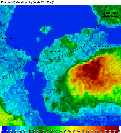
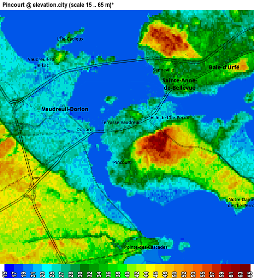
Below is the Elevation map of Pincourt, which displays elevation range with different colors. Scale of the first map is from 17 to 65 m (56 to 213 ft) with average elevation of 27.7 meters (=91 ft) [note 1]
These maps also provides idea of topography and contour of this city, they are displayed at different zoom levels. More info about maps, scale and edge coordinates you can find below images.
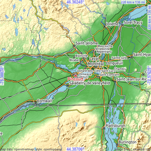
| \ | Map #1 | Map #2 | Topo.Map |
| Scale [m] | 17..65 m | 15..65 m | × |
| Scale [ft] | 56..213 ft | 49..213 ft | × |
| Average | 27.7 m = 91 ft | 29 m = 95 ft | × |
| Width | 6.86 km = 4.3 mi | 13.73 km = 8.5 mi | 219.6 km = 136.5 mi |
| Height | 6.86 km = 4.3 mi | 13.73 km = 8.5 mi | 219.6 km = 136.5 mi |
| ↑Max Latitude | 45.414237° | 45.445077° | 46.36245° |
| Latitude at center | 45.38338° | 45.38338° | 45.38338° |
| ↓Min Latitude | 45.352506° | 45.321615° | 44.38706° |
| ← Min Longitude | -74.026445° | -74.070391° | -75.38875° |
| Longitude center | -73.9825° | -73.9825° | -73.9825° |
| →Max Longitude | -73.938555° | -73.894609° | -72.57625° |
Nearby cities:
Cities around Pincourt sort by population:
• Vaudreuil-Dorion elevation 22 m
4.3 km,  295°
295°
• Kirkland 36 m
11.7 km,  50°
50°
• Beaconsfield 33 m
10.7 km,  58°
58°
• Saint-Lazare 56 m
11.9 km,  279°
279°
• Beauharnois 27 m
11.6 km,  132°
132°
• L'Île-Perrot 49 m
2.6 km,  90°
90°
• Notre-Dame-de-l'Île-Perrot 41 m
4.3 km,  115°
115°
• Sainte-Anne-de-Bellevue 34 m
3.8 km, 48°
• Baie-D'Urfé 40 m
6.2 km, 56°
• Melocheville 26 m
8.2 km,  154°
154°
• Saint-Jean-Baptiste 24 m
2.3 km,  262°
262°
• Les Cèdres 30 m
10.6 km,  209°
209°
Multilingual:
 En español:
Pincourt elevación 27 m.
 En France:
Pincourt élévation 27 m.


Sources and notes:
- [note 1] Map square and city borders are not equal. Map elevation data is calculated only from area inside that square.
- [src 1] Elevation data from geonames database provided with same terms of usage.
- [src 2] The elevation map of Pincourt is generated using elevation data from NASA's 3 arcsec (90m) resolution SRTM data.
- [src 3] Base (background) map © OpenStreetMap contributors tiles are generated by Geofabrik and OpenTopoMap.
Copyright & License:
This Pincourt Elevation Map is licensed under CC BY-SA. You may reuse any part from this page, if you give a proper credit by linking to this URL:
 More info on terms of use page.