Oxbow elevation
Oxbow (Saskatchewan), Canada elevation is 582 meters and Oxbow elevation in feet is 1909 ft above sea level [src 1]. Oxbow is a populated place (feature code) with elevation that is 324 meters (1063 ft) bigger than average city elevation in Canada.
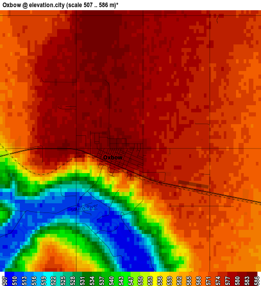
Below is the Elevation map of Oxbow, which displays elevation range with different colors. Scale of the first map is from 507 to 586 m (1663 to 1923 ft) with average elevation of 564.7 meters (=1853 ft) [note 1]
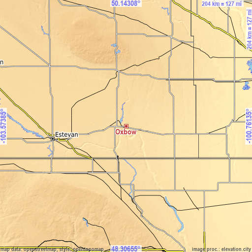
These maps also provides idea of topography and contour of this city, they are displayed at different zoom levels. More info about maps, scale and edge coordinates you can find below images.
| \ | Map #1 | Topo.Map |
| Scale [m] | 507..586 m | × |
| Scale [ft] | 1663..1923 ft | × |
| Average | 564.7 m = 1853 ft | × |
| Width | 6.38 km = 4 mi | 204.2 km = 126.9 mi |
| Height | 6.38 km = 4 mi | 204.2 km = 126.9 mi |
| ↑Max Latitude | 49.262037° | 50.14308° |
| Latitude at center | 49.23335° | 49.23335° |
| ↓Min Latitude | 49.204646° | 48.30655° |
| ← Min Longitude | -102.211545° | -103.57385° |
| Longitude center | -102.1676° | -102.1676° |
| →Max Longitude | -102.123655° | -100.76135° |
Nearby cities:
Cities around Oxbow sort by population:
• Brandon elevation 383 m
173.7 km,  66°
66°
• Estevan 563 m
60.4 km,  259°
259°
• Weyburn 568 m
130.9 km,  291°
291°
• Virden 442 m
112.5 km,  52°
52°
• Moosomin 581 m
106.3 km,  19°
19°
• Esterhazy 516 m
157.6 km,  2°
2°
• Souris 428 m
144.3 km, 72°
• Boissevain 514 m
153.3 km,  90°
90°
• Carlyle 630 m
45.1 km,  350°
350°
• Melita 443 m
85.1 km, 87°
• Rivers 478 m
164.7 km,  57°
57°
• Deloraine 503 m
121.6 km, 92°
Multilingual:
 En español:
Oxbow elevación 582 m.
 En France:
Oxbow élévation 582 m.


Sources and notes:
- [note 1] Map square and city borders are not equal. Map elevation data is calculated only from area inside that square.
- [src 1] Elevation data from geonames database provided with same terms of usage.
- [src 2] The elevation map of Oxbow is generated using elevation data from NASA's 3 arcsec (90m) resolution SRTM data.
- [src 3] Base (background) map © OpenStreetMap contributors tiles are generated by Geofabrik and OpenTopoMap.
Copyright & License:
This Oxbow Elevation Map is licensed under CC BY-SA. You may reuse any part from this page, if you give a proper credit by linking to this URL:
 More info on terms of use page.