Olds elevation
Olds (Alberta), Canada elevation is 1039 meters and Olds elevation in feet is 3409 ft above sea level [src 1]. Olds is a populated place (feature code) with elevation that is 781 meters (2562 ft) bigger than average city elevation in Canada.
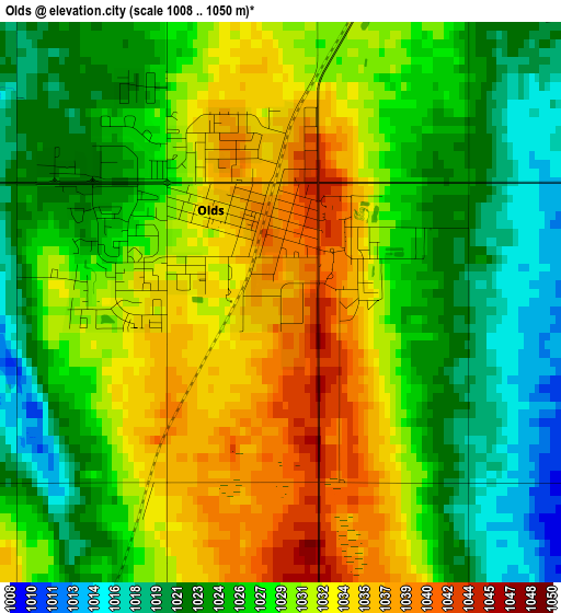
Below is the Elevation map of Olds, which displays elevation range with different colors. Scale of the first map is from 1008 to 1050 m (3307 to 3445 ft) with average elevation of 1028.3 meters (=3374 ft) [note 1]
These maps also provides idea of topography and contour of this city, they are displayed at different zoom levels. More info about maps, scale and edge coordinates you can find below images.
| \ | Map #1 | Map #2 | Topo.Map |
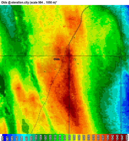
| Scale [m] | 1008..1050 m | 984..1050 m | × |
| Scale [ft] | 3307..3445 ft | 3228..3445 ft | × |
| Average | 1028.3 m = 3374 ft | 1018.5 m = 3342 ft | × |
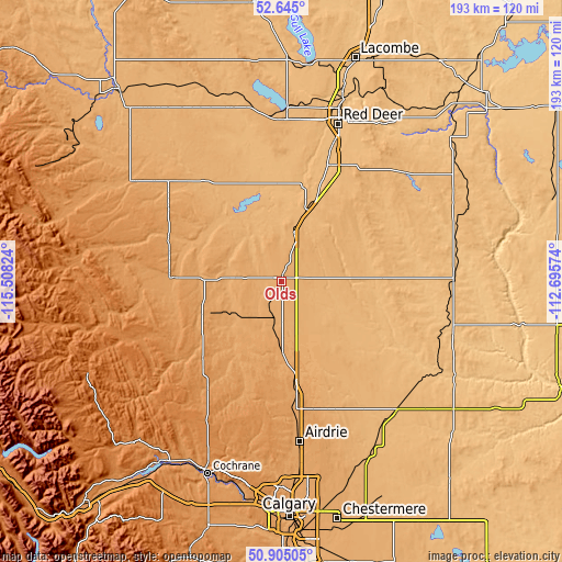
| Width | 6.05 km = 3.8 mi | 12.09 km = 7.5 mi | 193.5 km = 120.2 mi |
| Height | 6.05 km = 3.8 mi | 12.09 km = 7.5 mi | 193.4 km = 120.2 mi |
| ↑Max Latitude | 51.810588° | 51.83775° | 52.645° |
| Latitude at center | 51.78341° | 51.78341° | 51.78341° |
| ↓Min Latitude | 51.756216° | 51.729005° | 50.90505° |
| ← Min Longitude | -114.145935° | -114.189881° | -115.50824° |
| Longitude center | -114.10199° | -114.10199° | -114.10199° |
| →Max Longitude | -114.058045° | -114.014099° | -112.69574° |
Nearby cities:
Cities around Olds sort by population:
• Red Deer elevation 856 m
57.5 km,  20°
20°
• Airdrie 1086 m
53.9 km,  175°
175°
• Sylvan Lake 961 m
58.7 km,  1°
1°
• Didsbury 1032 m
13.2 km,  190°
190°
• Blackfalds 876 m
70.1 km, 17°
• Three Hills 897 m
58.1 km,  99°
99°
• Crossfield 1117 m
39.2 km,  173°
173°
• Sundre 1089 m
36.7 km,  272°
272°
• Carstairs 1059 m
24.1 km, 180°
• Penhold 895 m
42.1 km, 22°
• Springbrook 899 m
46.6 km, 19°
• Irricana 931 m
61.6 km,  146°
146°
Multilingual:
 En español:
Olds elevación 1039 m.
 En France:
Olds élévation 1039 m.


Sources and notes:
- [note 1] Map square and city borders are not equal. Map elevation data is calculated only from area inside that square.
- [src 1] Elevation data from geonames database provided with same terms of usage.
- [src 2] The elevation map of Olds is generated using elevation data from NASA's 3 arcsec (90m) resolution SRTM data.
- [src 3] Base (background) map © OpenStreetMap contributors tiles are generated by Geofabrik and OpenTopoMap.
Copyright & License:
This Olds Elevation Map is licensed under CC BY-SA. You may reuse any part from this page, if you give a proper credit by linking to this URL:
 More info on terms of use page.