Merritt elevation
Merritt (British Columbia, Thompson-Nicola Regional District), Canada elevation is 593 meters and Merritt elevation in feet is 1946 ft above sea level [src 1]. Merritt is a populated place (feature code) with elevation that is 335 meters (1099 ft) bigger than average city elevation in Canada.
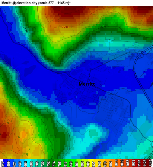
Below is the Elevation map of Merritt, which displays elevation range with different colors. Scale of the first map is from 577 to 1145 m (1893 to 3757 ft) with average elevation of 726.8 meters (=2385 ft) [note 1]
These maps also provides idea of topography and contour of this city, they are displayed at different zoom levels. More info about maps, scale and edge coordinates you can find below images.
| \ | Map #1 | Map #2 | Topo.Map |
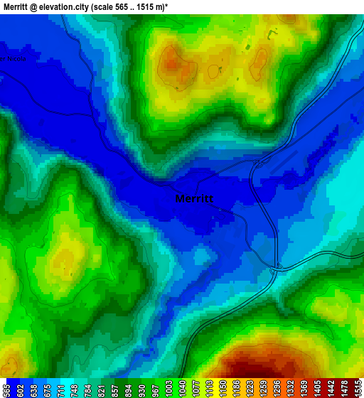
| Scale [m] | 577..1145 m | 565..1515 m | × |
| Scale [ft] | 1893..3757 ft | 1854..4970 ft | × |
| Average | 726.8 m = 2385 ft | 836.5 m = 2744 ft | × |
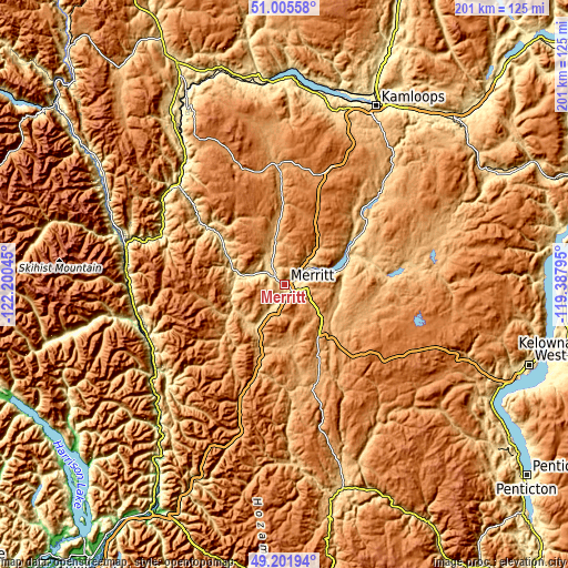
| Width | 6.27 km = 3.9 mi | 12.53 km = 7.8 mi | 200.5 km = 124.6 mi |
| Height | 6.27 km = 3.9 mi | 12.53 km = 7.8 mi | 200.5 km = 124.6 mi |
| ↑Max Latitude | 50.140423° | 50.16858° | 51.00558° |
| Latitude at center | 50.11225° | 50.11225° | 50.11225° |
| ↓Min Latitude | 50.08406° | 50.055854° | 49.20194° |
| ← Min Longitude | -120.838145° | -120.882091° | -122.20045° |
| Longitude center | -120.7942° | -120.7942° | -120.7942° |
| →Max Longitude | -120.750255° | -120.706309° | -119.38795° |
Nearby cities:
Cities around Merritt sort by population:
• Kelowna elevation 350 m
96.9 km,  105°
105°
• Kamloops 414 m
70.2 km,  28°
28°
• West Kelowna 484 m
90.9 km, 107°
• Duck Lake 432 m
100.4 km,  96°
96°
• Summerland 475 m
98.7 km,  125°
125°
• Hope 45 m
93.5 km,  209°
209°
• Princeton 660 m
75.5 km,  164°
164°
• Lillooet 276 m
103.4 km,  308°
308°
• Logan Lake 1136 m
43.1 km,  359°
359°
• Ashcroft 307 m
76.3 km,  333°
333°
• Peachland 342 m
84.9 km,  116°
116°
• Cache Creek 464 m
86.2 km, 334°
Multilingual:
 En español:
Merritt elevación 593 m.
 En France:
Merritt élévation 593 m.


Sources and notes:
- [note 1] Map square and city borders are not equal. Map elevation data is calculated only from area inside that square.
- [src 1] Elevation data from geonames database provided with same terms of usage.
- [src 2] The elevation map of Merritt is generated using elevation data from NASA's 3 arcsec (90m) resolution SRTM data.
- [src 3] Base (background) map © OpenStreetMap contributors tiles are generated by Geofabrik and OpenTopoMap.
Copyright & License:
This Merritt Elevation Map is licensed under CC BY-SA. You may reuse any part from this page, if you give a proper credit by linking to this URL:
 More info on terms of use page.