Mayerthorpe elevation
Mayerthorpe (Alberta), Canada elevation is 716 meters and Mayerthorpe elevation in feet is 2349 ft above sea level [src 1]. Mayerthorpe is a populated place (feature code) with elevation that is 458 meters (1503 ft) bigger than average city elevation in Canada.
Below is the Elevation map of Mayerthorpe, which displays elevation range with different colors. Scale of the first map is from 673 to 747 m (2208 to 2451 ft) with average elevation of 711 meters (=2333 ft) [note 1]
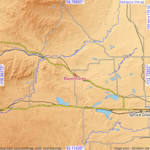
These maps also provides idea of topography and contour of this city, they are displayed at different zoom levels. More info about maps, scale and edge coordinates you can find below images.
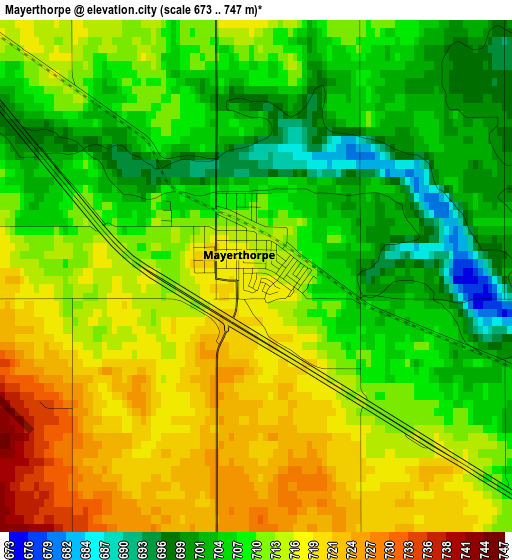
| \ | Map #1 | Topo.Map |
| Scale [m] | 673..747 m | × |
| Scale [ft] | 2208..2451 ft | × |
| Average | 711 m = 2333 ft | × |
| Width | 5.75 km = 3.6 mi | 184 km = 114.3 mi |
| Height | 5.75 km = 3.6 mi | 184 km = 114.3 mi |
| ↑Max Latitude | 53.976003° | 54.76953° |
| Latitude at center | 53.95015° | 53.95015° |
| ↓Min Latitude | 53.924281° | 53.11435° |
| ← Min Longitude | -115.179415° | -116.54172° |
| Longitude center | -115.13547° | -115.13547° |
| →Max Longitude | -115.091525° | -113.72922° |
Nearby cities:
Cities around Mayerthorpe sort by population:
• St. Albert elevation 663 m
104.6 km,  109°
109°
• Spruce Grove 704 m
92.5 km,  120°
120°
• Stony Plain 705 m
87.8 km, 121°
• Whitecourt 689 m
42.2 km,  301°
301°
• Morinville 701 m
98.7 km,  99°
99°
• Edson 913 m
94.7 km,  244°
244°
• Drayton Valley 846 m
82.1 km,  173°
173°
• Devon 695 m
112.8 km,  125°
125°
• Westlock 651 m
85.6 km,  74°
74°
• Barrhead 656 m
52 km, 66°
• Swan Hills 1139 m
87 km,  348°
348°
• Bon Accord 700 m
113.2 km, 96°
Multilingual:
 En español:
Mayerthorpe elevación 716 m.
 En France:
Mayerthorpe élévation 716 m.
 Auf Deutsch:
Mayerthorpe höhe über dem Meeresspiegel ist 716 m.

Sources and notes:
- [note 1] Map square and city borders are not equal. Map elevation data is calculated only from area inside that square.
- [src 1] Elevation data from geonames database provided with same terms of usage.
- [src 2] The elevation map of Mayerthorpe is generated using elevation data from NASA's 3 arcsec (90m) resolution SRTM data.
- [src 3] Base (background) map © OpenStreetMap contributors tiles are generated by Geofabrik and OpenTopoMap.
Copyright & License:
This Mayerthorpe Elevation Map is licensed under CC BY-SA. You may reuse any part from this page, if you give a proper credit by linking to this URL:
 More info on terms of use page.