Langley elevation
Langley (British Columbia, Metro Vancouver Regional District), Canada elevation is 13 meters and Langley elevation in feet is 43 ft above sea level [src 1]. Langley is a populated place (feature code) with elevation that is 245 meters (804 ft) smaller than average city elevation in Canada.
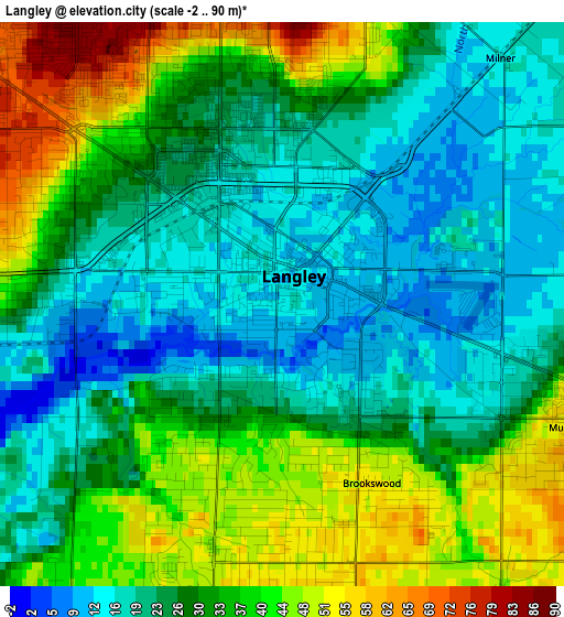
Below is the Elevation map of Langley, which displays elevation range with different colors. Scale of the first map is from -2 to 90 m (-7 to 295 ft) with average elevation of 29.7 meters (=97 ft) [note 1]
These maps also provides idea of topography and contour of this city, they are displayed at different zoom levels. More info about maps, scale and edge coordinates you can find below images.
| \ | Map #1 | Map #2 | Topo.Map |
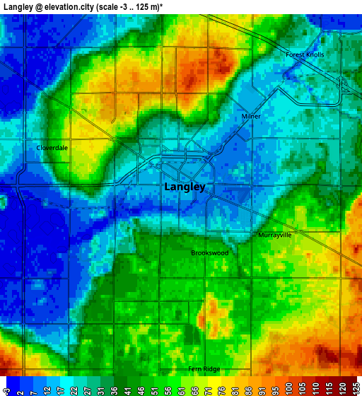
| Scale [m] | -2..90 m | -3..125 m | × |
| Scale [ft] | -7..295 ft | -10..410 ft | × |
| Average | 29.7 m = 97 ft | 40.1 m = 132 ft | × |
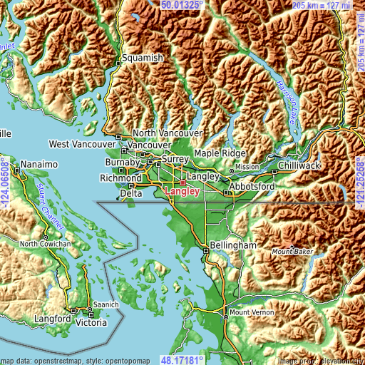
| Width | 6.4 km = 4 mi | 12.8 km = 8 mi | 204.7 km = 127.2 mi |
| Height | 6.4 km = 4 mi | 12.8 km = 8 mi | 204.7 km = 127.2 mi |
| ↑Max Latitude | 49.129834° | 49.158581° | 50.01325° |
| Latitude at center | 49.10107° | 49.10107° | 49.10107° |
| ↓Min Latitude | 49.072289° | 49.043492° | 48.17181° |
| ← Min Longitude | -122.702775° | -122.746721° | -124.06508° |
| Longitude center | -122.65883° | -122.65883° | -122.65883° |
| →Max Longitude | -122.614885° | -122.570939° | -121.25258° |
Nearby cities:
Cities around Langley sort by population:
• Surrey elevation 82 m
12.1 km,  272°
272°
• Coquitlam 39 m
22.3 km,  336°
336°
• Delta 81 m
18.7 km,  284°
284°
• Maple Ridge 42 m
13.8 km,  17°
17°
• White Rock 80 m
14.1 km,  228°
228°
• New Westminster 64 m
21.8 km,  302°
302°
• Port Coquitlam 16 m
20.1 km, 336°
• Port Moody 30 m
23.4 km,  328°
328°
• Walnut Grove 40 m
7.2 km,  10°
10°
• Pitt Meadows 13 m
13.5 km,  350°
350°
• Aldergrove 102 m
14.5 km,  109°
109°
• Aldergrove East 121 m
17.9 km, 106°
Multilingual:
 En español:
Ciudad de Langley elevación 13 m.
 En France:
Langley élévation 13 m.


Sources and notes:
- [note 1] Map square and city borders are not equal. Map elevation data is calculated only from area inside that square.
- [src 1] Elevation data from geonames database provided with same terms of usage.
- [src 2] The elevation map of Langley is generated using elevation data from NASA's 3 arcsec (90m) resolution SRTM data.
- [src 3] Base (background) map © OpenStreetMap contributors tiles are generated by Geofabrik and OpenTopoMap.
Copyright & License:
This Langley Elevation Map is licensed under CC BY-SA. You may reuse any part from this page, if you give a proper credit by linking to this URL:
 More info on terms of use page.