Lakefield elevation
Lakefield (Ontario, Peterborough County), Canada elevation is 241 meters and Lakefield elevation in feet is 791 ft above sea level [src 1]. Lakefield is a populated place (feature code) with elevation that is 17 meters (56 ft) smaller than average city elevation in Canada.
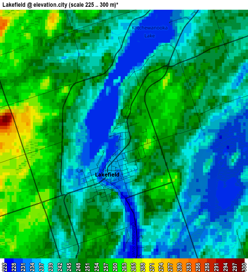
Below is the Elevation map of Lakefield, which displays elevation range with different colors. Scale of the first map is from 225 to 300 m (738 to 984 ft) with average elevation of 245.9 meters (=807 ft) [note 1]
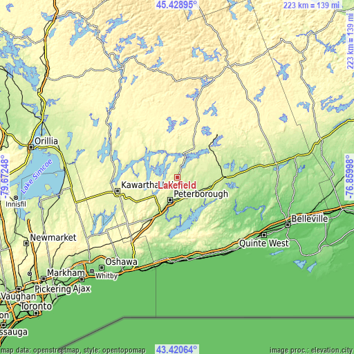
These maps also provides idea of topography and contour of this city, they are displayed at different zoom levels. More info about maps, scale and edge coordinates you can find below images.
| \ | Map #1 | Topo.Map |
| Scale [m] | 225..300 m | × |
| Scale [ft] | 738..984 ft | × |
| Average | 245.9 m = 807 ft | × |
| Width | 6.98 km = 4.3 mi | 223.3 km = 138.8 mi |
| Height | 6.98 km = 4.3 mi | 223.3 km = 138.8 mi |
| ↑Max Latitude | 44.464791° | 45.42895° |
| Latitude at center | 44.43342° | 44.43342° |
| ↓Min Latitude | 44.402032° | 43.42064° |
| ← Min Longitude | -78.310175° | -79.67248° |
| Longitude center | -78.26623° | -78.26623° |
| →Max Longitude | -78.222285° | -76.85998° |
Nearby cities:
Cities around Lakefield sort by population:
• Oshawa elevation 105 m
75.4 km,  218°
218°
• Peterborough 188 m
15.3 km,  195°
195°
• Quinte West 130 m
62.3 km,  116°
116°
• Lindsay 261 m
38.2 km,  255°
255°
• Cobourg 82 m
53.3 km,  171°
171°
• Port Hope 144 m
47.5 km,  192°
192°
• Stirling 125 m
58.9 km,  104°
104°
• Millbrook 215 m
34.7 km, 204°
• Madoc 176 m
63.4 km,  82°
82°
• Norwood 212 m
23.2 km, 103°
• Omemee 252 m
27.7 km,  237°
237°
• Haliburton Village 337 m
71.6 km,  343°
343°
Multilingual:
 En español:
Lakefield elevación 241 m.
 En France:
Lakefield élévation 241 m.
 Auf Deutsch:
Lakefield höhe über dem Meeresspiegel ist 241 m.

Sources and notes:
- [note 1] Map square and city borders are not equal. Map elevation data is calculated only from area inside that square.
- [src 1] Elevation data from geonames database provided with same terms of usage.
- [src 2] The elevation map of Lakefield is generated using elevation data from NASA's 3 arcsec (90m) resolution SRTM data.
- [src 3] Base (background) map © OpenStreetMap contributors tiles are generated by Geofabrik and OpenTopoMap.
Copyright & License:
This Lakefield Elevation Map is licensed under CC BY-SA. You may reuse any part from this page, if you give a proper credit by linking to this URL:
 More info on terms of use page.