Fall River elevation
Fall River (Nova Scotia), Canada elevation is 33 meters and Fall River elevation in feet is 108 ft above sea level [src 1]. Fall River is a populated place (feature code) with elevation that is 225 meters (738 ft) smaller than average city elevation in Canada.
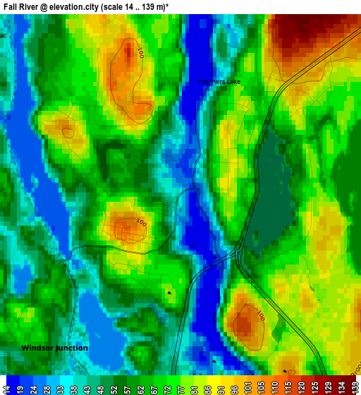
Below is the Elevation map of Fall River, which displays elevation range with different colors. Scale of the first map is from 14 to 139 m (46 to 456 ft) with average elevation of 62.8 meters (=206 ft) [note 1]
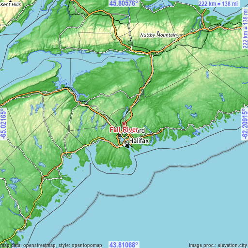
These maps also provides idea of topography and contour of this city, they are displayed at different zoom levels. More info about maps, scale and edge coordinates you can find below images.
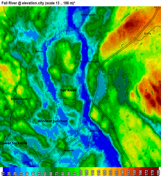
| \ | Map #1 | Map #2 | Topo.Map |
| Scale [m] | 14..139 m | 13..186 m | × |
| Scale [ft] | 46..456 ft | 43..610 ft | × |
| Average | 62.8 m = 206 ft | 75 m = 246 ft | × |
| Width | 6.93 km = 4.3 mi | 13.86 km = 8.6 mi | 221.8 km = 137.8 mi |
| Height | 6.93 km = 4.3 mi | 13.86 km = 8.6 mi | 221.8 km = 137.8 mi |
| ↑Max Latitude | 44.848015° | 44.879163° | 45.80576° |
| Latitude at center | 44.81685° | 44.81685° | 44.81685° |
| ↓Min Latitude | 44.785668° | 44.75447° | 43.81068° |
| ← Min Longitude | -63.659345° | -63.703291° | -65.02165° |
| Longitude center | -63.6154° | -63.6154° | -63.6154° |
| →Max Longitude | -63.571455° | -63.527509° | -62.20915° |
Nearby cities:
Cities around Fall River sort by population:
• Halifax elevation 23 m
19.4 km,  169°
169°
• Dartmouth 35 m
16.5 km, 169°
• Lower Sackville 53 m
6.7 km,  227°
227°
• Cole Harbour 49 m
19.5 km,  145°
145°
• Windsor 11 m
44.7 km,  294°
294°
• Wolfville 53 m
66 km,  296°
296°
• Lake Echo 18 m
20.6 km,  116°
116°
• Lantz 18 m
21.3 km,  29°
29°
• Chester 9 m
58 km,  238°
238°
• Cow Bay 41 m
25.2 km,  144°
144°
• Hantsport 11 m
51.4 km, 302°
• English Corner 116 m
16.1 km, 234°
Multilingual:
 En español:
Fall River elevación 33 m.
 En France:
Fall River élévation 33 m.
 Auf Deutsch:
Fall River höhe über dem Meeresspiegel ist 33 m.

Sources and notes:
- [note 1] Map square and city borders are not equal. Map elevation data is calculated only from area inside that square.
- [src 1] Elevation data from geonames database provided with same terms of usage.
- [src 2] The elevation map of Fall River is generated using elevation data from NASA's 3 arcsec (90m) resolution SRTM data.
- [src 3] Base (background) map © OpenStreetMap contributors tiles are generated by Geofabrik and OpenTopoMap.
Copyright & License:
This Fall River Elevation Map is licensed under CC BY-SA. You may reuse any part from this page, if you give a proper credit by linking to this URL:
 More info on terms of use page.