Channel-Port aux Basques elevation
Channel-Port aux Basques (Newfoundland and Labrador), Canada elevation is 1 meters and Channel-Port aux Basques elevation in feet is 3 ft above sea level [src 1]. Channel-Port aux Basques is a populated place (feature code) with elevation that is 257 meters (843 ft) smaller than average city elevation in Canada.
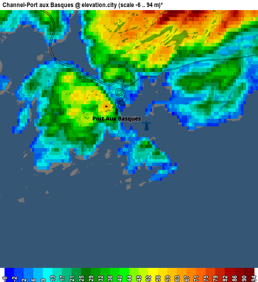
Below is the Elevation map of Channel-Port aux Basques, which displays elevation range with different colors. Scale of the first map is from -6 to 94 m (-20 to 308 ft) with average elevation of 29.3 meters (=96 ft) [note 1]
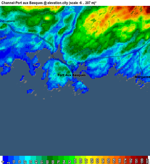
These maps also provides idea of topography and contour of this city, they are displayed at different zoom levels. More info about maps, scale and edge coordinates you can find below images.
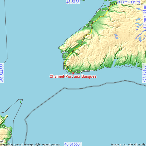
| \ | Map #1 | Map #2 | Topo.Map |
| Scale [m] | -6..94 m | -6..207 m | × |
| Scale [ft] | -20..308 ft | -20..679 ft | × |
| Average | 29.3 m = 96 ft | 52.6 m = 173 ft | × |
| Width | 6.59 km = 4.1 mi | 13.19 km = 8.2 mi | 211 km = 131.1 mi |
| Height | 6.59 km = 4.1 mi | 13.19 km = 8.2 mi | 211 km = 131.1 mi |
| ↑Max Latitude | 47.602499° | 47.632122° | 48.513° |
| Latitude at center | 47.57286° | 47.57286° | 47.57286° |
| ↓Min Latitude | 47.543204° | 47.513531° | 46.61553° |
| ← Min Longitude | -59.182025° | -59.225971° | -60.54433° |
| Longitude center | -59.13808° | -59.13808° | -59.13808° |
| →Max Longitude | -59.094135° | -59.050189° | -57.73183° |
Nearby cities:
Cities around Channel-Port aux Basques sort by population:
• Sydney elevation 6 m
178.5 km,  206°
206°
• Glace Bay 15 m
165.2 km,  202°
202°
• Corner Brook 17 m
176.5 km,  29°
29°
• Sydney Mines 18 m
169.7 km, 208°
• Stephenville 15 m
116.2 km,  20°
20°
• Deer Lake 34 m
217.5 km,  35°
35°
• Pasadena 28 m
196.8 km, 35°
• Eskasoni 3 12 m
213.1 km, 211°
• Harbour Breton 1 m
250.9 km,  92°
92°
• Burgeo 1 m
114.3 km, 87°
• Stephenville Crossing 5 m
115.7 km, 26°
• Bay St. George South 25 m
76.1 km, 16°
Multilingual:
 En español:
Channel-Port aux Basques elevación 1 m.
 En France:
Channel-Port-aux-Basques élévation 1 m.
 Auf Deutsch:
Port aux Basques höhe über dem Meeresspiegel ist 1 m.
 На русском:
Channel-Port aux Basques высота над уровнем моря 1 м
Sources and notes:
- [note 1] Map square and city borders are not equal. Map elevation data is calculated only from area inside that square.
- [src 1] Elevation data from geonames database provided with same terms of usage.
- [src 2] The elevation map of Channel-Port aux Basques is generated using elevation data from NASA's 3 arcsec (90m) resolution SRTM data.
- [src 3] Base (background) map © OpenStreetMap contributors tiles are generated by Geofabrik and OpenTopoMap.
Copyright & License:
This Channel-Port aux Basques Elevation Map is licensed under CC BY-SA. You may reuse any part from this page, if you give a proper credit by linking to this URL:
 More info on terms of use page.