Brantford elevation
Brantford (Ontario, Regional Municipality of Niagara), Canada elevation is 200 meters and Brantford elevation in feet is 656 ft above sea level [src 1]. Brantford is a populated place (feature code) with elevation that is 58 meters (190 ft) smaller than average city elevation in Canada.
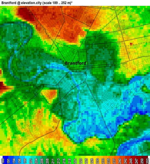
Below is the Elevation map of Brantford, which displays elevation range with different colors. Scale of the first map is from 189 to 252 m (620 to 827 ft) with average elevation of 215.6 meters (=707 ft) [note 1]
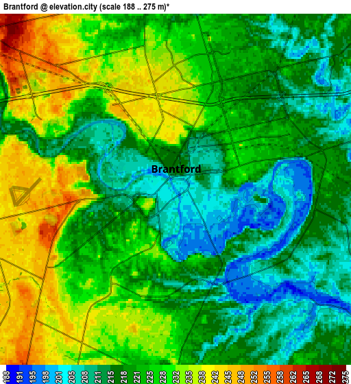
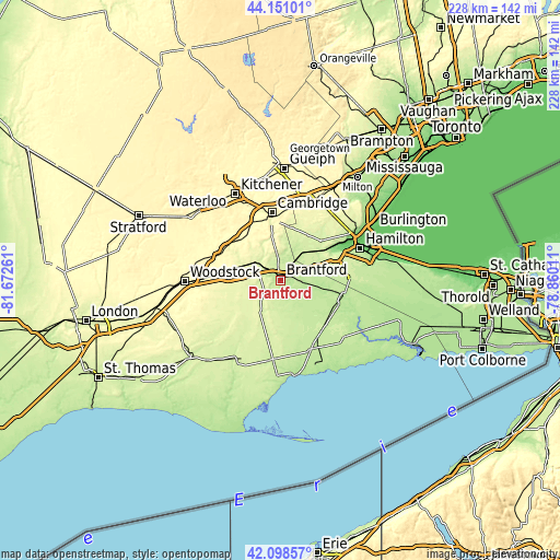
These maps also provides idea of topography and contour of this city, they are displayed at different zoom levels. More info about maps, scale and edge coordinates you can find below images.
| \ | Map #1 | Map #2 | Topo.Map |
| Scale [m] | 189..252 m | 188..275 m | × |
| Scale [ft] | 620..827 ft | 617..902 ft | × |
| Average | 215.6 m = 707 ft | 222.9 m = 731 ft | × |
| Width | 7.13 km = 4.4 mi | 14.26 km = 8.9 mi | 228.2 km = 141.8 mi |
| Height | 7.13 km = 4.4 mi | 14.26 km = 8.9 mi | 228.2 km = 141.8 mi |
| ↑Max Latitude | 43.165461° | 43.197506° | 44.15101° |
| Latitude at center | 43.1334° | 43.1334° | 43.1334° |
| ↓Min Latitude | 43.101322° | 43.069227° | 42.09857° |
| ← Min Longitude | -80.310305° | -80.354251° | -81.67261° |
| Longitude center | -80.26636° | -80.26636° | -80.26636° |
| →Max Longitude | -80.222415° | -80.178469° | -78.86011° |
Nearby cities:
Cities around Brantford sort by population:
• Hamilton elevation 95 m
36.2 km,  68°
68°
• Cambridge 272 m
25.5 km,  351°
351°
• Norfolk County 235 m
34.7 km,  195°
195°
• Brant 245 m
6.8 km,  270°
270°
• Ancaster 253 m
24.5 km, 67°
• Simcoe 210 m
33.5 km,  184°
184°
• Paris 255 m
12 km,  307°
307°
• St. George 239 m
12.5 km,  5°
5°
• Waterford 240 m
22.3 km, 183°
• Burford 258 m
13.6 km,  255°
255°
• Plattsville 302 m
33.9 km,  303°
303°
• Jarvis 210 m
30.9 km,  154°
154°
Multilingual:
 En español:
Brantford elevación 200 m.
 En France:
Brantford élévation 200 m.
 Auf Deutsch:
Brantford höhe über dem Meeresspiegel ist 200 m.

Sources and notes:
- [note 1] Map square and city borders are not equal. Map elevation data is calculated only from area inside that square.
- [src 1] Elevation data from geonames database provided with same terms of usage.
- [src 2] The elevation map of Brantford is generated using elevation data from NASA's 3 arcsec (90m) resolution SRTM data.
- [src 3] Base (background) map © OpenStreetMap contributors tiles are generated by Geofabrik and OpenTopoMap.
Copyright & License:
This Brantford Elevation Map is licensed under CC BY-SA. You may reuse any part from this page, if you give a proper credit by linking to this URL:
 More info on terms of use page.