Baie-Comeau elevation
Baie-Comeau (Quebec, Côte-Nord), Canada elevation is 76 meters and Baie-Comeau elevation in feet is 249 ft above sea level [src 1]. Baie-Comeau is a populated place (feature code) with elevation that is 182 meters (597 ft) smaller than average city elevation in Canada.
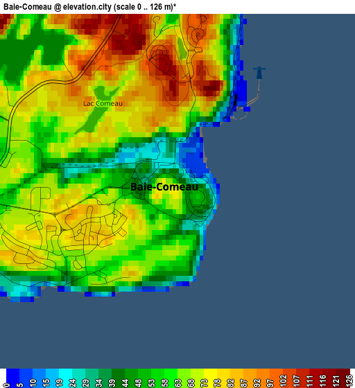
Below is the Elevation map of Baie-Comeau, which displays elevation range with different colors. Scale of the first map is from 0 to 126 m (0 to 413 ft) with average elevation of 65.9 meters (=216 ft) [note 1]
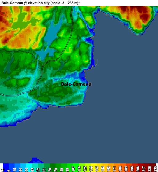
These maps also provides idea of topography and contour of this city, they are displayed at different zoom levels. More info about maps, scale and edge coordinates you can find below images.
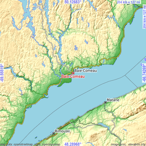
| \ | Map #1 | Map #2 | Topo.Map |
| Scale [m] | 0..126 m | -3..235 m | × |
| Scale [ft] | 0..413 ft | -10..771 ft | × |
| Average | 65.9 m = 216 ft | 86.9 m = 285 ft | × |
| Width | 6.38 km = 4 mi | 12.77 km = 7.9 mi | 204.3 km = 126.9 mi |
| Height | 6.38 km = 4 mi | 12.77 km = 7.9 mi | 204.3 km = 126.9 mi |
| ↑Max Latitude | 49.245487° | 49.274167° | 50.12683° |
| Latitude at center | 49.21679° | 49.21679° | 49.21679° |
| ↓Min Latitude | 49.188077° | 49.159347° | 48.28968° |
| ← Min Longitude | -68.192885° | -68.236831° | -69.55519° |
| Longitude center | -68.14894° | -68.14894° | -68.14894° |
| →Max Longitude | -68.104995° | -68.061049° | -66.74269° |
Nearby cities:
Cities around Baie-Comeau sort by population:
• Rimouski elevation 23 m
89.7 km,  197°
197°
• Matane 74 m
62.9 km,  133°
133°
• Hauterive 10 m
8.3 km,  253°
253°
• Mont-Joli 81 m
70.4 km,  182°
182°
• Amqui 161 m
98.8 km,  147°
147°
• Sainte-Anne-des-Monts 15 m
120.9 km,  94°
94°
• Forestville 84 m
86.6 km,  232°
232°
• Chute-aux-Outardes 31 m
21.3 km,  238°
238°
• Cap-Chat 45 m
107.4 km,  96°
96°
• Le Bic 110 m
101.7 km, 203°
• Luceville 5 m
76.9 km,  193°
193°
• Saint-Alexandre 13 m
129.2 km,  45°
45°
Multilingual:
 En español:
Baie-Comeau elevación 76 m.
 En France:
Baie-Comeau élévation 76 m.
 Auf Deutsch:
Baie-Comeau höhe über dem Meeresspiegel ist 76 m.

Sources and notes:
- [note 1] Map square and city borders are not equal. Map elevation data is calculated only from area inside that square.
- [src 1] Elevation data from geonames database provided with same terms of usage.
- [src 2] The elevation map of Baie-Comeau is generated using elevation data from NASA's 3 arcsec (90m) resolution SRTM data.
- [src 3] Base (background) map © OpenStreetMap contributors tiles are generated by Geofabrik and OpenTopoMap.
Copyright & License:
This Baie-Comeau Elevation Map is licensed under CC BY-SA. You may reuse any part from this page, if you give a proper credit by linking to this URL:
 More info on terms of use page.