Ivyanyets elevation
Ivyanyets (Minsk), Belarus elevation is 197 meters and Ivyanyets elevation in feet is 646 ft above sea level [src 1]. Ivyanyets is a populated place (feature code) with elevation that is 30 meters (98 ft) bigger than average city elevation in Belarus.
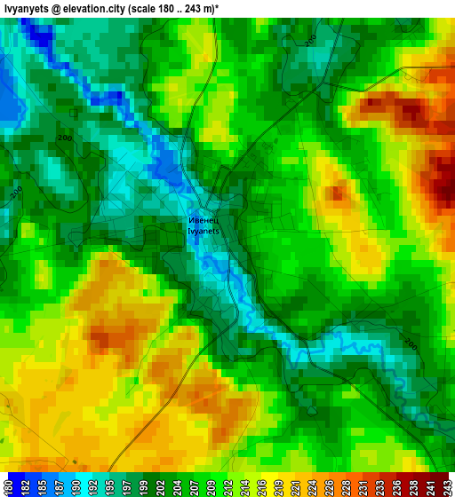
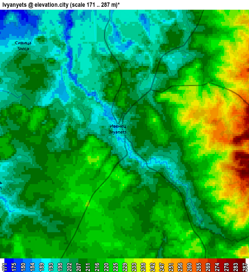
Below is the Elevation map of Ivyanyets, which displays elevation range with different colors. Scale of the first map is from 180 to 243 m (591 to 797 ft) with average elevation of 207.9 meters (=682 ft) [note 1]
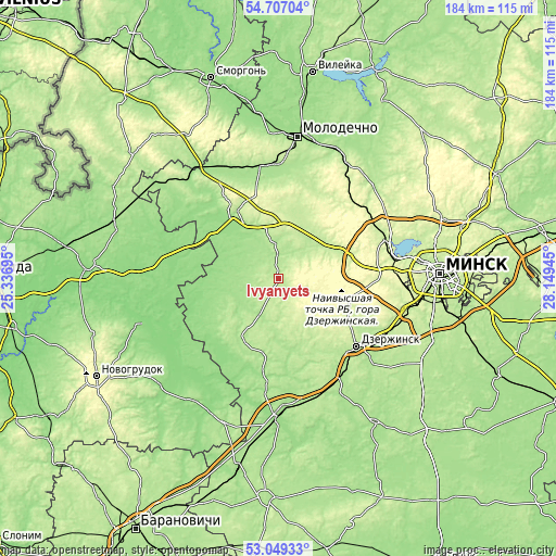
These maps also provides idea of topography and contour of this city, they are displayed at different zoom levels. More info about maps, scale and edge coordinates you can find below images.
| \ | Map #1 | Map #2 | Topo.Map |
| Scale [m] | 180..243 m | 171..287 m | × |
| Scale [ft] | 591..797 ft | 561..942 ft | × |
| Average | 207.9 m = 682 ft | 212.5 m = 697 ft | × |
| Width | 5.76 km = 3.6 mi | 11.52 km = 7.2 mi | 184.3 km = 114.5 mi |
| Height | 5.76 km = 3.6 mi | 11.52 km = 7.2 mi | 184.3 km = 114.5 mi |
| ↑Max Latitude | 53.912293° | 53.93817° | 54.70704° |
| Latitude at center | 53.8864° | 53.8864° | 53.8864° |
| ↓Min Latitude | 53.860491° | 53.834566° | 53.04933° |
| ← Min Longitude | 26.699255° | 26.655309° | 25.33695° |
| Longitude center | 26.7432° | 26.7432° | 26.7432° |
| →Max Longitude | 26.787145° | 26.831091° | 28.14945° |
Nearby cities:
Cities around Ivyanyets sort by population:
• Dzyarzhynsk elevation 193 m
34.4 km,  131°
131°
• Zaslawye 226 m
37.1 km,  68°
68°
• Fanipol 220 m
41.6 km,  111°
111°
• Valozhyn 203 m
26.6 km,  327°
327°
• Rakaw 212 m
22.4 km, 66°
• Radashkovichy 196 m
44.2 km,  47°
47°
• Enyerhyetykaw 183 m
39 km,  148°
148°
• Pyatryshki 239 m
37.1 km,  56°
56°
• Stan’kava 186 m
42.9 km, 131°
• Novosel’ye 303 m
30.2 km,  83°
83°
• Azyartso 249 m
42.8 km,  96°
96°
• Khatsyezhyna 257 m
37 km,  86°
86°
Multilingual:
 En español:
Ivyanyets elevación 197 m.
 En France:
Ivyanyets élévation 197 m.
 Auf Deutsch:
Ivyanyets höhe über dem Meeresspiegel ist 197 m.

Sources and notes:
- [note 1] Map square and city borders are not equal. Map elevation data is calculated only from area inside that square.
- [src 1] Elevation data from geonames database provided with same terms of usage.
- [src 2] The elevation map of Ivyanyets is generated using elevation data from NASA's 3 arcsec (90m) resolution SRTM data.
- [src 3] Base (background) map © OpenStreetMap contributors tiles are generated by Geofabrik and OpenTopoMap.
Copyright & License:
This Ivyanyets Elevation Map is licensed under CC BY-SA. You may reuse any part from this page, if you give a proper credit by linking to this URL:
 More info on terms of use page.