Novosel’ye elevation
Novosel’ye (Minsk), Belarus elevation is 303 meters and Novosel’ye elevation in feet is 994 ft above sea level [src 1]. Novosel’ye is a populated place (feature code) with elevation that is 136 meters (446 ft) bigger than average city elevation in Belarus.
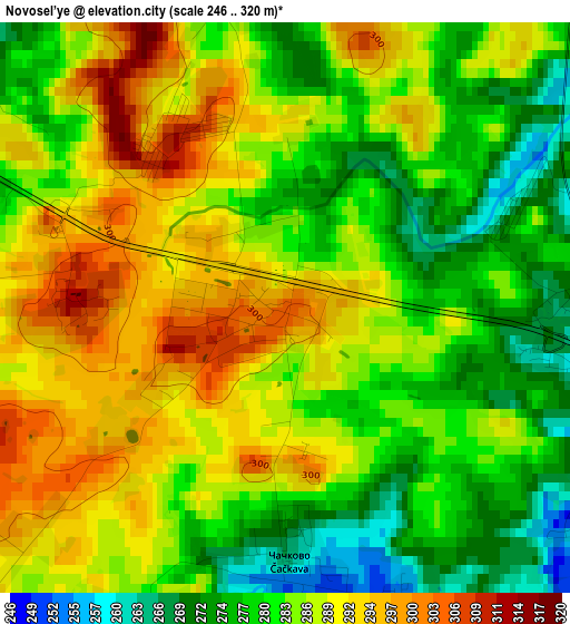
Below is the Elevation map of Novosel’ye, which displays elevation range with different colors. Scale of the first map is from 246 to 320 m (807 to 1050 ft) with average elevation of 284.8 meters (=934 ft) [note 1]
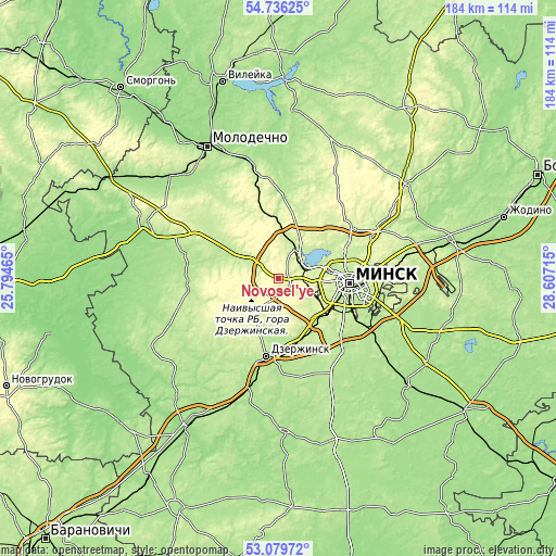
These maps also provides idea of topography and contour of this city, they are displayed at different zoom levels. More info about maps, scale and edge coordinates you can find below images.
| \ | Map #1 | Topo.Map |
| Scale [m] | 246..320 m | × |
| Scale [ft] | 807..1050 ft | × |
| Average | 284.8 m = 934 ft | × |
| Width | 5.76 km = 3.6 mi | 184.2 km = 114.5 mi |
| Height | 5.76 km = 3.6 mi | 184.2 km = 114.5 mi |
| ↑Max Latitude | 53.942074° | 54.73625° |
| Latitude at center | 53.9162° | 53.9162° |
| ↓Min Latitude | 53.89031° | 53.07972° |
| ← Min Longitude | 27.156955° | 25.79465° |
| Longitude center | 27.2009° | 27.2009° |
| →Max Longitude | 27.244845° | 28.60715° |
Nearby cities:
Cities around Novosel’ye sort by population:
• Zaslawye elevation 226 m
11.5 km,  22°
22°
• Fanipol 220 m
20.4 km,  154°
154°
• Rakaw 212 m
11 km,  301°
301°
• Syenitsa 209 m
23.8 km,  113°
113°
• Zhdanovichy 216 m
15 km,  78°
78°
• Yubilyeyny 217 m
23.6 km,  117°
117°
• Pyatryshki 239 m
17 km,  3°
3°
• Schomyslitsa 242 m
19.6 km, 122°
• Syomkava 220 m
18.9 km,  56°
56°
• Atolina 228 m
21.4 km,  134°
134°
• Azyartso 249 m
15.1 km, 124°
• Khatsyezhyna 257 m
7 km,  96°
96°
Multilingual:
 En español:
Novosel’ye elevación 303 m.
 En France:
Novosel’ye élévation 303 m.
 Auf Deutsch:
Novosel’ye höhe über dem Meeresspiegel ist 303 m.

Sources and notes:
- [note 1] Map square and city borders are not equal. Map elevation data is calculated only from area inside that square.
- [src 1] Elevation data from geonames database provided with same terms of usage.
- [src 2] The elevation map of Novosel’ye is generated using elevation data from NASA's 3 arcsec (90m) resolution SRTM data.
- [src 3] Base (background) map © OpenStreetMap contributors tiles are generated by Geofabrik and OpenTopoMap.
Copyright & License:
This Novosel’ye Elevation Map is licensed under CC BY-SA. You may reuse any part from this page, if you give a proper credit by linking to this URL:
 More info on terms of use page.