Kirawsk elevation
Kirawsk (Mogilev), Belarus elevation is 162 meters and Kirawsk elevation in feet is 531 ft above sea level [src 1]. Kirawsk is a seat of a second-order administrative division (feature code) with elevation that is 5 meters (16 ft) smaller than average city elevation in Belarus.
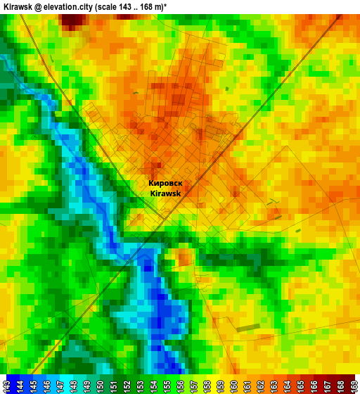
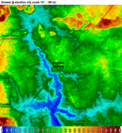
Below is the Elevation map of Kirawsk, which displays elevation range with different colors. Scale of the first map is from 143 to 168 m (469 to 551 ft) with average elevation of 156.4 meters (=513 ft) [note 1]
These maps also provides idea of topography and contour of this city, they are displayed at different zoom levels. More info about maps, scale and edge coordinates you can find below images.
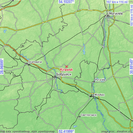
| \ | Map #1 | Map #2 | Topo.Map |
| Scale [m] | 143..168 m | 141..186 m | × |
| Scale [ft] | 469..551 ft | 463..610 ft | × |
| Average | 156.4 m = 513 ft | 158.5 m = 520 ft | × |
| Width | 5.84 km = 3.6 mi | 11.69 km = 7.3 mi | 187 km = 116.2 mi |
| Height | 5.84 km = 3.6 mi | 11.69 km = 7.3 mi | 187 km = 116.2 mi |
| ↑Max Latitude | 53.295574° | 53.321831° | 54.10207° |
| Latitude at center | 53.2693° | 53.2693° | 53.2693° |
| ↓Min Latitude | 53.24301° | 53.216704° | 52.41999° |
| ← Min Longitude | 29.431255° | 29.387309° | 28.06895° |
| Longitude center | 29.4752° | 29.4752° | 29.4752° |
| →Max Longitude | 29.519145° | 29.563091° | 30.88145° |
Nearby cities:
Cities around Kirawsk sort by population:
• Babruysk elevation 159 m
22.3 km,  229°
229°
• Zhlobin 139 m
55.7 km,  138°
138°
• Rahachow 143 m
43 km,  117°
117°
• Asipovichy 157 m
55.7 km,  273°
273°
• Bykhaw 155 m
58.2 km,  61°
61°
• Hlusk 144 m
66.7 km, 232°
• Klichaw 154 m
26.5 km,  339°
339°
• Yalizava 151 m
34.4 km,  294°
294°
• Krasnyy Bereg 147 m
48.2 km,  82°
82°
• Parychy 135 m
51.9 km,  184°
184°
• Myshkavichy 157 m
6.3 km,  157°
157°
• Hlusha 169 m
45.9 km,  243°
243°
Multilingual:
 En español:
Kirawsk elevación 162 m.
 En France:
Kirawsk élévation 162 m.


Sources and notes:
- [note 1] Map square and city borders are not equal. Map elevation data is calculated only from area inside that square.
- [src 1] Elevation data from geonames database provided with same terms of usage.
- [src 2] The elevation map of Kirawsk is generated using elevation data from NASA's 3 arcsec (90m) resolution SRTM data.
- [src 3] Base (background) map © OpenStreetMap contributors tiles are generated by Geofabrik and OpenTopoMap.
Copyright & License:
This Kirawsk Elevation Map is licensed under CC BY-SA. You may reuse any part from this page, if you give a proper credit by linking to this URL:
 More info on terms of use page.