Rahachow elevation
Rahachow (Gomel Oblast), Belarus elevation is 143 meters and Rahachow elevation in feet is 469 ft above sea level [src 1]. Rahachow is a seat of a second-order administrative division (feature code) with elevation that is 24 meters (79 ft) smaller than average city elevation in Belarus.
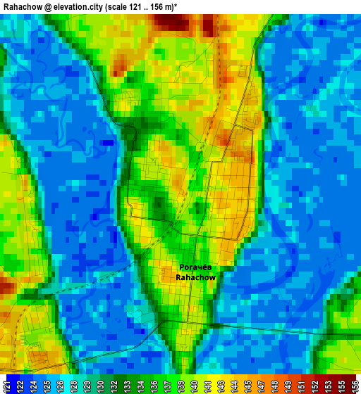
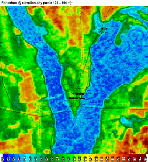
Below is the Elevation map of Rahachow, which displays elevation range with different colors. Scale of the first map is from 121 to 156 m (397 to 512 ft) with average elevation of 132.3 meters (=434 ft) [note 1]
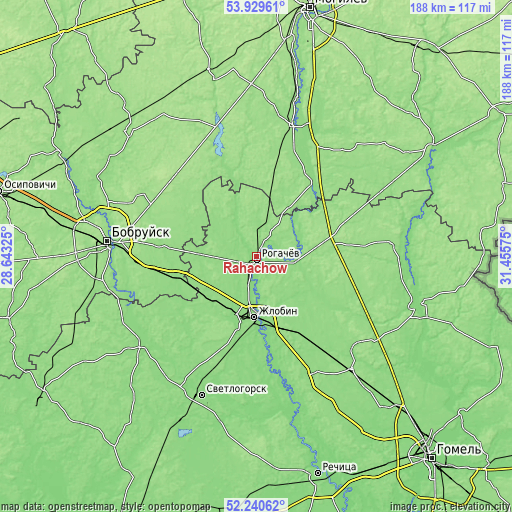
These maps also provides idea of topography and contour of this city, they are displayed at different zoom levels. More info about maps, scale and edge coordinates you can find below images.
| \ | Map #1 | Map #2 | Topo.Map |
| Scale [m] | 121..156 m | 121..164 m | × |
| Scale [ft] | 397..512 ft | 397..538 ft | × |
| Average | 132.3 m = 434 ft | 136.6 m = 448 ft | × |
| Width | 5.87 km = 3.6 mi | 11.74 km = 7.3 mi | 187.8 km = 116.7 mi |
| Height | 5.87 km = 3.6 mi | 11.74 km = 7.3 mi | 187.8 km = 116.7 mi |
| ↑Max Latitude | 53.119782° | 53.146147° | 53.92961° |
| Latitude at center | 53.0934° | 53.0934° | 53.0934° |
| ↓Min Latitude | 53.067002° | 53.040588° | 52.24062° |
| ← Min Longitude | 30.005555° | 29.961609° | 28.64325° |
| Longitude center | 30.0495° | 30.0495° | 30.0495° |
| →Max Longitude | 30.093445° | 30.137391° | 31.45575° |
Nearby cities:
Cities around Rahachow sort by population:
• Babruysk elevation 159 m
55.5 km,  275°
275°
• Zhlobin 139 m
22.4 km,  184°
184°
• Svyetlahorsk 142 m
55.3 km,  202°
202°
• Bykhaw 155 m
49.3 km,  15°
15°
• Kirawsk 162 m
43 km,  297°
297°
• Chachersk 146 m
61.3 km,  108°
108°
• Krasnyy Bereg 147 m
27.9 km, 20°
• Parychy 135 m
53.2 km,  232°
232°
• Myshkavichy 157 m
38.4 km,  291°
291°
• Dowsk 167 m
28.3 km,  75°
75°
• Buda-Kashalyova 147 m
54.4 km,  140°
140°
• Karma 155 m
50.4 km,  85°
85°
Multilingual:
 En español:
Rahachow elevación 143 m.
 En France:
Rahatchow élévation 143 m.
 Auf Deutsch:
Rahatschou höhe über dem Meeresspiegel ist 143 m.

Sources and notes:
- [note 1] Map square and city borders are not equal. Map elevation data is calculated only from area inside that square.
- [src 1] Elevation data from geonames database provided with same terms of usage.
- [src 2] The elevation map of Rahachow is generated using elevation data from NASA's 3 arcsec (90m) resolution SRTM data.
- [src 3] Base (background) map © OpenStreetMap contributors tiles are generated by Geofabrik and OpenTopoMap.
Copyright & License:
This Rahachow Elevation Map is licensed under CC BY-SA. You may reuse any part from this page, if you give a proper credit by linking to this URL:
 More info on terms of use page.