Lahoysk elevation
Lahoysk (Minsk), Belarus elevation is 192 meters and Lahoysk elevation in feet is 630 ft above sea level [src 1]. Lahoysk is a seat of a second-order administrative division (feature code) with elevation that is 25 meters (82 ft) bigger than average city elevation in Belarus.
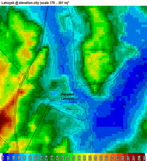
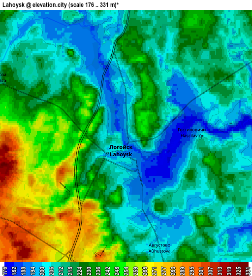
Below is the Elevation map of Lahoysk, which displays elevation range with different colors. Scale of the first map is from 176 to 301 m (577 to 988 ft) with average elevation of 211.9 meters (=695 ft) [note 1]
These maps also provides idea of topography and contour of this city, they are displayed at different zoom levels. More info about maps, scale and edge coordinates you can find below images.
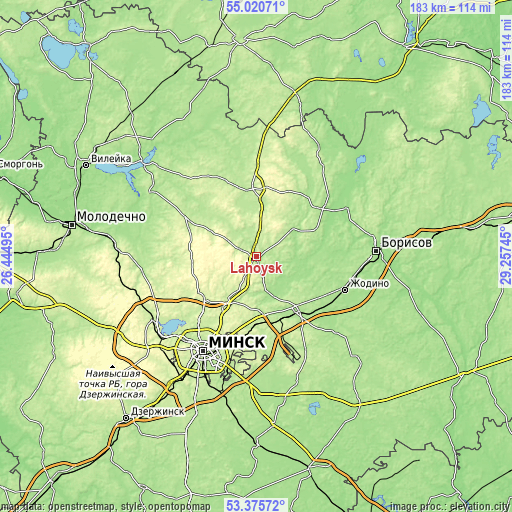
| \ | Map #1 | Map #2 | Topo.Map |
| Scale [m] | 176..301 m | 176..331 m | × |
| Scale [ft] | 577..988 ft | 577..1086 ft | × |
| Average | 211.9 m = 695 ft | 223.4 m = 733 ft | × |
| Width | 5.72 km = 3.6 mi | 11.43 km = 7.1 mi | 182.9 km = 113.6 mi |
| Height | 5.72 km = 3.6 mi | 11.43 km = 7.1 mi | 182.9 km = 113.6 mi |
| ↑Max Latitude | 54.232094° | 54.257772° | 55.02071° |
| Latitude at center | 54.2064° | 54.2064° | 54.2064° |
| ↓Min Latitude | 54.18069° | 54.154964° | 53.37572° |
| ← Min Longitude | 27.807255° | 27.763309° | 26.44495° |
| Longitude center | 27.8512° | 27.8512° | 27.8512° |
| →Max Longitude | 27.895145° | 27.939091° | 29.25745° |
Nearby cities:
Cities around Lahoysk sort by population:
• Lyasny elevation 246 m
24.3 km,  204°
204°
• Horad Smalyavichy 175 m
25.5 km,  142°
142°
• Plyeshchanitsy 211 m
24.2 km,  356°
356°
• Borovlyany 234 m
25.4 km,  206°
206°
• Bal’shavik 226 m
29.2 km,  219°
219°
• Astrashytski Haradok 223 m
18.7 km, 212°
• Октябрьский 185 m
29.2 km,  129°
129°
• Slabada 205 m
22.1 km,  174°
174°
• Usiazh 190 m
17.7 km,  145°
145°
• Lyeskawka 250 m
24.5 km, 201°
• Zyembin 181 m
29.3 km,  54°
54°
• Korolëv Stan 210 m
24.7 km,  188°
188°
Multilingual:
 En español:
Lahoysk elevación 192 m.
 En France:
Lahoysk élévation 192 m.


Sources and notes:
- [note 1] Map square and city borders are not equal. Map elevation data is calculated only from area inside that square.
- [src 1] Elevation data from geonames database provided with same terms of usage.
- [src 2] The elevation map of Lahoysk is generated using elevation data from NASA's 3 arcsec (90m) resolution SRTM data.
- [src 3] Base (background) map © OpenStreetMap contributors tiles are generated by Geofabrik and OpenTopoMap.
Copyright & License:
This Lahoysk Elevation Map is licensed under CC BY-SA. You may reuse any part from this page, if you give a proper credit by linking to this URL:
 More info on terms of use page.