Korolëv Stan elevation
Korolëv Stan (Minsk), Belarus elevation is 210 meters and Korolëv Stan elevation in feet is 689 ft above sea level [src 1]. Korolëv Stan is a populated place (feature code) with elevation that is 43 meters (141 ft) bigger than average city elevation in Belarus.
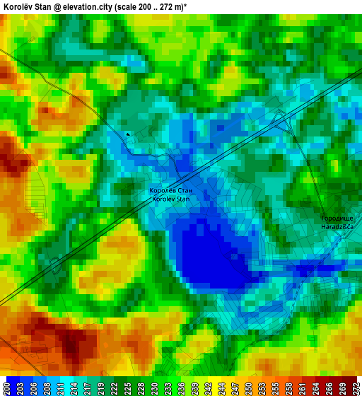
Below is the Elevation map of Korolëv Stan, which displays elevation range with different colors. Scale of the first map is from 200 to 272 m (656 to 892 ft) with average elevation of 228.2 meters (=749 ft) [note 1]
These maps also provides idea of topography and contour of this city, they are displayed at different zoom levels. More info about maps, scale and edge coordinates you can find below images.
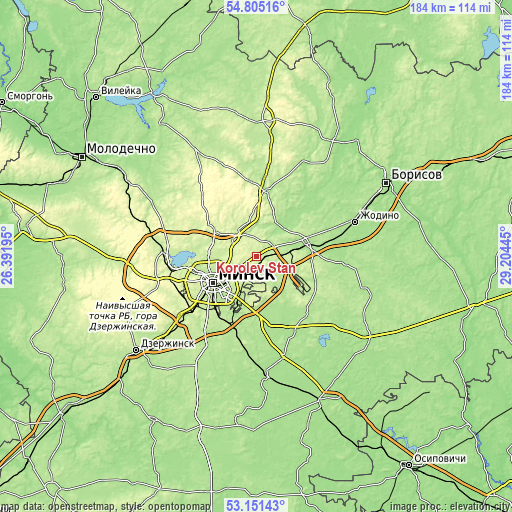
| \ | Map #1 | Topo.Map |
| Scale [m] | 200..272 m | × |
| Scale [ft] | 656..892 ft | × |
| Average | 228.2 m = 749 ft | × |
| Width | 5.75 km = 3.6 mi | 183.9 km = 114.3 mi |
| Height | 5.75 km = 3.6 mi | 183.9 km = 114.3 mi |
| ↑Max Latitude | 54.012331° | 54.80516° |
| Latitude at center | 53.9865° | 53.9865° |
| ↓Min Latitude | 53.960653° | 53.15143° |
| ← Min Longitude | 27.754255° | 26.39195° |
| Longitude center | 27.7982° | 27.7982° |
| →Max Longitude | 27.842145° | 29.20445° |
Nearby cities:
Cities around Korolëv Stan sort by population:
• Minsk elevation 222 m
17.9 km,  237°
237°
• Kalodzishchy 242 m
4.8 km,  192°
192°
• Lyasny 246 m
7 km,  289°
289°
• Horad Smalyavichy 175 m
19.5 km,  77°
77°
• Borovlyany 234 m
8.2 km,  282°
282°
• Bal’shavik 226 m
15.2 km, 277°
• Zamostochye 190 m
19.1 km,  166°
166°
• Astrashytski Haradok 223 m
11 km,  322°
322°
• Vyaliki Trastsyanets 203 m
16 km,  200°
200°
• Slabada 205 m
6.3 km,  66°
66°
• Usiazh 190 m
16.9 km,  53°
53°
• Lyeskawka 250 m
6 km, 287°
Multilingual:
 En español:
Korolëv Stan elevación 210 m.
 En France:
Korolëv Stan élévation 210 m.
 Auf Deutsch:
Korolëv Stan höhe über dem Meeresspiegel ist 210 m.

Sources and notes:
- [note 1] Map square and city borders are not equal. Map elevation data is calculated only from area inside that square.
- [src 1] Elevation data from geonames database provided with same terms of usage.
- [src 2] The elevation map of Korolëv Stan is generated using elevation data from NASA's 3 arcsec (90m) resolution SRTM data.
- [src 3] Base (background) map © OpenStreetMap contributors tiles are generated by Geofabrik and OpenTopoMap.
Copyright & License:
This Korolëv Stan Elevation Map is licensed under CC BY-SA. You may reuse any part from this page, if you give a proper credit by linking to this URL:
 More info on terms of use page.