Luninyets elevation
Luninyets (Brest), Belarus elevation is 139 meters and Luninyets elevation in feet is 456 ft above sea level [src 1]. Luninyets is a seat of a second-order administrative division (feature code) with elevation that is 28 meters (92 ft) smaller than average city elevation in Belarus.
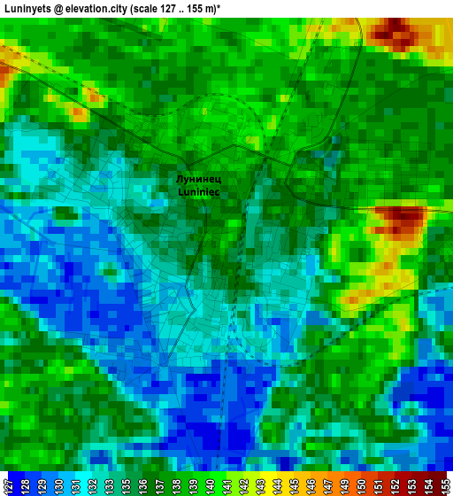
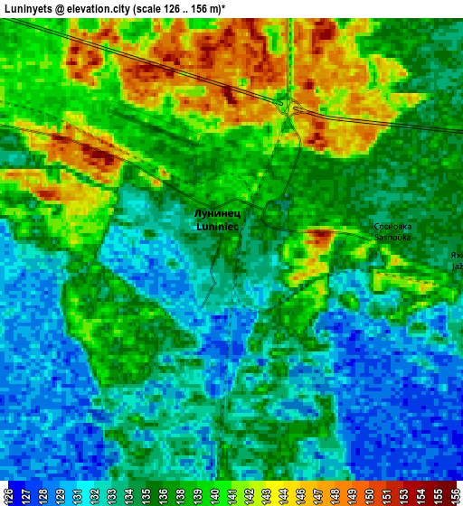
Below is the Elevation map of Luninyets, which displays elevation range with different colors. Scale of the first map is from 127 to 155 m (417 to 509 ft) with average elevation of 135.5 meters (=445 ft) [note 1]
These maps also provides idea of topography and contour of this city, they are displayed at different zoom levels. More info about maps, scale and edge coordinates you can find below images.
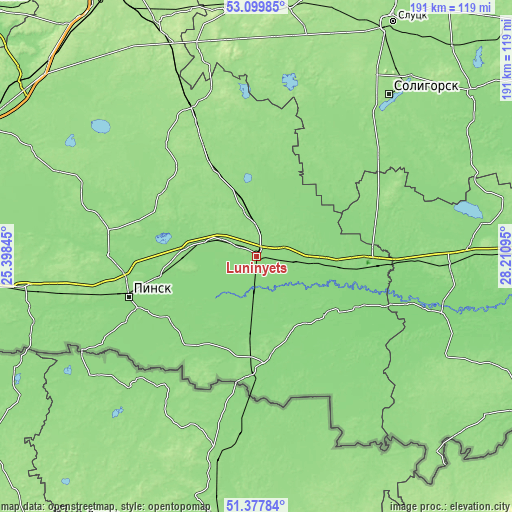
| \ | Map #1 | Map #2 | Topo.Map |
| Scale [m] | 127..155 m | 126..156 m | × |
| Scale [ft] | 417..509 ft | 413..512 ft | × |
| Average | 135.5 m = 445 ft | 136.4 m = 448 ft | × |
| Width | 5.98 km = 3.7 mi | 11.97 km = 7.4 mi | 191.5 km = 119 mi |
| Height | 5.98 km = 3.7 mi | 11.97 km = 7.4 mi | 191.5 km = 119 mi |
| ↑Max Latitude | 52.274098° | 52.300979° | 53.09985° |
| Latitude at center | 52.2472° | 52.2472° | 52.2472° |
| ↓Min Latitude | 52.220286° | 52.193356° | 51.37784° |
| ← Min Longitude | 26.760755° | 26.716809° | 25.39845° |
| Longitude center | 26.8047° | 26.8047° | 26.8047° |
| →Max Longitude | 26.848645° | 26.892591° | 28.21095° |
Nearby cities:
Cities around Luninyets sort by population:
• Pinsk elevation 139 m
50.3 km,  254°
254°
• Mikashevichy 128 m
45.8 km,  94°
94°
• Hantsavichy 160 m
62.2 km,  335°
335°
• Stolin 139 m
39.7 km,  175°
175°
• Davyd-Haradok 130 m
35.2 km,  127°
127°
• Starobin 146 m
69.4 km,  39°
39°
• Turaw 125 m
66.5 km,  107°
107°
• Lahishyn 171 m
56.6 km,  280°
280°
• Asnyezhytsy 140 m
46.4 km,  262°
262°
• Hotsk 140 m
38 km, 36°
• Horad Pinsk 138 m
51.8 km, 254°
• Horad Luninyets 136 m
0.5 km,  313°
313°
Multilingual:
 En español:
Luninyets elevación 139 m.
 En France:
Luninyets élévation 139 m.
 Auf Deutsch:
Luninyets höhe über dem Meeresspiegel ist 139 m.

Sources and notes:
- [note 1] Map square and city borders are not equal. Map elevation data is calculated only from area inside that square.
- [src 1] Elevation data from geonames database provided with same terms of usage.
- [src 2] The elevation map of Luninyets is generated using elevation data from NASA's 3 arcsec (90m) resolution SRTM data.
- [src 3] Base (background) map © OpenStreetMap contributors tiles are generated by Geofabrik and OpenTopoMap.
Copyright & License:
This Luninyets Elevation Map is licensed under CC BY-SA. You may reuse any part from this page, if you give a proper credit by linking to this URL:
 More info on terms of use page.