Mikashevichy elevation
Mikashevichy (Brest), Belarus elevation is 128 meters and Mikashevichy elevation in feet is 420 ft above sea level [src 1]. Mikashevichy is a populated place (feature code) with elevation that is 39 meters (128 ft) smaller than average city elevation in Belarus.
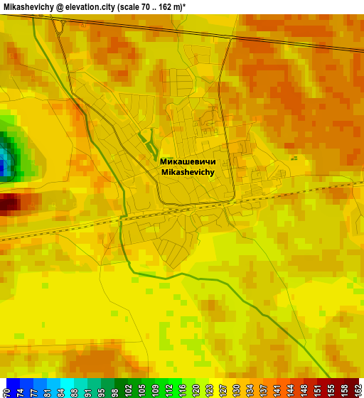
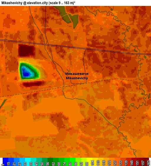
Below is the Elevation map of Mikashevichy, which displays elevation range with different colors. Scale of the first map is from 70 to 162 m (230 to 531 ft) with average elevation of 129.9 meters (=426 ft) [note 1]
These maps also provides idea of topography and contour of this city, they are displayed at different zoom levels. More info about maps, scale and edge coordinates you can find below images.
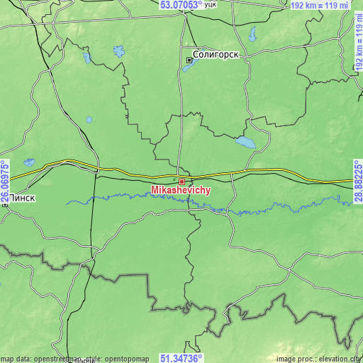
| \ | Map #1 | Map #2 | Topo.Map |
| Scale [m] | 70..162 m | 9..163 m | × |
| Scale [ft] | 230..531 ft | 30..535 ft | × |
| Average | 129.9 m = 426 ft | 129.5 m = 425 ft | × |
| Width | 5.99 km = 3.7 mi | 11.97 km = 7.4 mi | 191.6 km = 119.1 mi |
| Height | 5.99 km = 3.7 mi | 11.97 km = 7.4 mi | 191.6 km = 119.1 mi |
| ↑Max Latitude | 52.244216° | 52.271115° | 53.07053° |
| Latitude at center | 52.2173° | 52.2173° | 52.2173° |
| ↓Min Latitude | 52.190368° | 52.16342° | 51.34736° |
| ← Min Longitude | 27.432055° | 27.388109° | 26.06975° |
| Longitude center | 27.476° | 27.476° | 27.476° |
| →Max Longitude | 27.519945° | 27.563891° | 28.88225° |
Nearby cities:
Cities around Mikashevichy sort by population:
• Salihorsk elevation 157 m
63.6 km,  3°
3°
• Luninyets 139 m
45.8 km,  274°
274°
• Zhytkavichy 137 m
25.9 km,  90°
90°
• Pyetrykaw 137 m
70 km,  98°
98°
• Stolin 139 m
56.3 km,  229°
229°
• Davyd-Haradok 130 m
25.2 km,  224°
224°
• Starobin 146 m
56.6 km,  358°
358°
• Chyrvonaya Slabada 157 m
73.6 km,  343°
343°
• Turaw 125 m
24.2 km,  133°
133°
• Sarachy 140 m
73.2 km,  30°
30°
• Hotsk 140 m
40.9 km,  325°
325°
• Horad Luninyets 136 m
46.2 km, 274°
Multilingual:
 En español:
Mikashevichy elevación 128 m.
 En France:
Mikashevichy élévation 128 m.
 Auf Deutsch:
Mikashevichy höhe über dem Meeresspiegel ist 128 m.

Sources and notes:
- [note 1] Map square and city borders are not equal. Map elevation data is calculated only from area inside that square.
- [src 1] Elevation data from geonames database provided with same terms of usage.
- [src 2] The elevation map of Mikashevichy is generated using elevation data from NASA's 3 arcsec (90m) resolution SRTM data.
- [src 3] Base (background) map © OpenStreetMap contributors tiles are generated by Geofabrik and OpenTopoMap.
Copyright & License:
This Mikashevichy Elevation Map is licensed under CC BY-SA. You may reuse any part from this page, if you give a proper credit by linking to this URL:
 More info on terms of use page.