Myory elevation
Myory (Vitebsk), Belarus elevation is 146 meters and Myory elevation in feet is 479 ft above sea level [src 1]. Myory is a seat of a second-order administrative division (feature code) with elevation that is 21 meters (69 ft) smaller than average city elevation in Belarus.
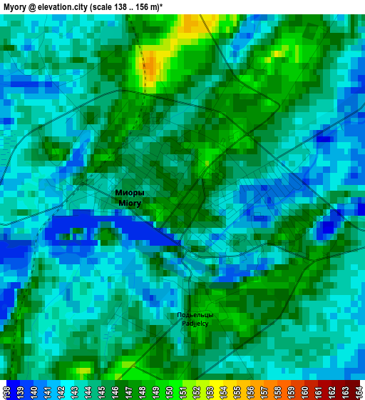
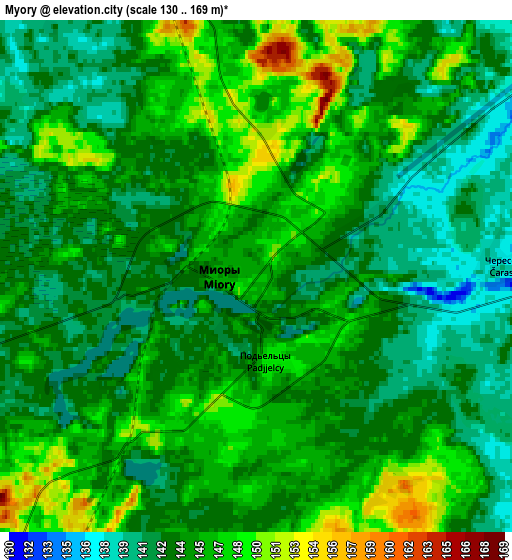
Below is the Elevation map of Myory, which displays elevation range with different colors. Scale of the first map is from 138 to 156 m (453 to 512 ft) with average elevation of 144.1 meters (=473 ft) [note 1]
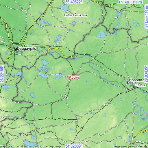
These maps also provides idea of topography and contour of this city, they are displayed at different zoom levels. More info about maps, scale and edge coordinates you can find below images.
| \ | Map #1 | Map #2 | Topo.Map |
| Scale [m] | 138..156 m | 130..169 m | × |
| Scale [ft] | 453..512 ft | 427..554 ft | × |
| Average | 144.1 m = 473 ft | 143.9 m = 472 ft | × |
| Width | 5.52 km = 3.4 mi | 11.04 km = 6.9 mi | 176.6 km = 109.7 mi |
| Height | 5.52 km = 3.4 mi | 11.04 km = 6.9 mi | 176.6 km = 109.7 mi |
| ↑Max Latitude | 55.647006° | 55.671796° | 56.40822° |
| Latitude at center | 55.6222° | 55.6222° | 55.6222° |
| ↓Min Latitude | 55.597379° | 55.572541° | 54.82009° |
| ← Min Longitude | 27.584155° | 27.540209° | 26.22185° |
| Longitude center | 27.6281° | 27.6281° | 27.6281° |
| →Max Longitude | 27.672045° | 27.715991° | 29.03435° |
Nearby cities:
Cities around Myory sort by population:
• Navapolatsk elevation 131 m
61.8 km,  99°
99°
• Polatsk 129 m
74.3 km, 101°
• Hlybokaye 159 m
53.9 km,  175°
175°
• Pastavy 140 m
75.4 km,  221°
221°
• Braslaw 139 m
36.9 km,  273°
273°
• Vyerkhnyadzvinsk 108 m
26 km,  48°
48°
• Sharkawshchyna 129 m
29.9 km,  199°
199°
• Dzisna 113 m
36.9 km, 99°
• Vidzy 140 m
67.7 km,  248°
248°
• Mosar 143 m
45.6 km,  193°
193°
• Druya 110 m
21.8 km,  329°
329°
• Osveya 140 m
53 km,  34°
34°
Multilingual:
 En español:
Myory elevación 146 m.
 En France:
Myory élévation 146 m.


Sources and notes:
- [note 1] Map square and city borders are not equal. Map elevation data is calculated only from area inside that square.
- [src 1] Elevation data from geonames database provided with same terms of usage.
- [src 2] The elevation map of Myory is generated using elevation data from NASA's 3 arcsec (90m) resolution SRTM data.
- [src 3] Base (background) map © OpenStreetMap contributors tiles are generated by Geofabrik and OpenTopoMap.
Copyright & License:
This Myory Elevation Map is licensed under CC BY-SA. You may reuse any part from this page, if you give a proper credit by linking to this URL:
 More info on terms of use page.