Mstsislaw elevation
Mstsislaw (Mogilev), Belarus elevation is 203 meters and Mstsislaw elevation in feet is 666 ft above sea level [src 1]. Mstsislaw is a seat of a second-order administrative division (feature code) with elevation that is 36 meters (118 ft) bigger than average city elevation in Belarus.
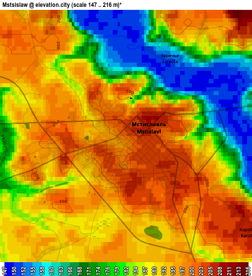
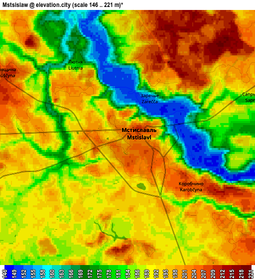
Below is the Elevation map of Mstsislaw, which displays elevation range with different colors. Scale of the first map is from 147 to 216 m (482 to 709 ft) with average elevation of 187.5 meters (=615 ft) [note 1]
These maps also provides idea of topography and contour of this city, they are displayed at different zoom levels. More info about maps, scale and edge coordinates you can find below images.
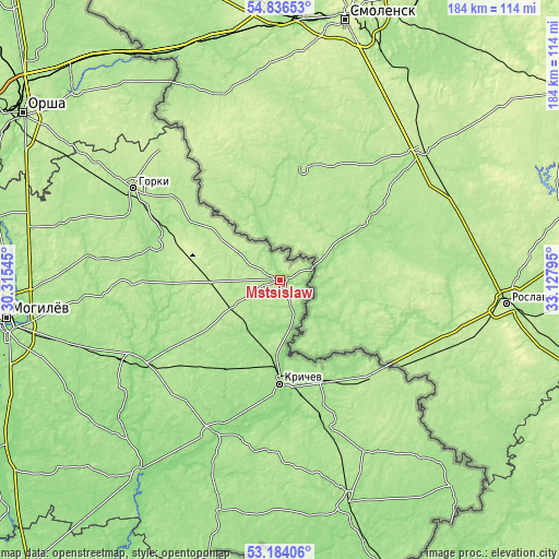
| \ | Map #1 | Map #2 | Topo.Map |
| Scale [m] | 147..216 m | 146..221 m | × |
| Scale [ft] | 482..709 ft | 479..725 ft | × |
| Average | 187.5 m = 615 ft | 189.7 m = 622 ft | × |
| Width | 5.74 km = 3.6 mi | 11.48 km = 7.1 mi | 183.7 km = 114.1 mi |
| Height | 5.74 km = 3.6 mi | 11.48 km = 7.1 mi | 183.7 km = 114.1 mi |
| ↑Max Latitude | 54.044311° | 54.070106° | 54.83653° |
| Latitude at center | 54.0185° | 54.0185° | 54.0185° |
| ↓Min Latitude | 53.992673° | 53.96683° | 53.18406° |
| ← Min Longitude | 31.677755° | 31.633809° | 30.31545° |
| Longitude center | 31.7217° | 31.7217° | 31.7217° |
| →Max Longitude | 31.765645° | 31.809591° | 33.12795° |
Nearby cities:
Cities around Mstsislaw sort by population:
• Horki elevation 182 m
56.4 km,  301°
301°
• Krychaw 168 m
34 km,  180°
180°
• Klimavichy 174 m
48.2 km,  161°
161°
• Kastsyukovichy 172 m
77.2 km, 163°
• Chavusy 176 m
54.3 km,  244°
244°
• Slawharad 158 m
79.6 km,  216°
216°
• Cherykaw 167 m
54.7 km,  203°
203°
• Krasnapollye 165 m
78.9 km, 195°
• Drybin 179 m
42.5 km,  285°
285°
• Khodasy 202 m
18.9 km, 237°
• Ramanavichy 176 m
77.9 km,  257°
257°
• Horad Krychaw 156 m
35.5 km, 180°
Multilingual:
 En español:
Mstsislaw elevación 203 m.
 En France:
Mstsislaw élévation 203 m.
 Auf Deutsch:
Mszislau höhe über dem Meeresspiegel ist 203 m.

Sources and notes:
- [note 1] Map square and city borders are not equal. Map elevation data is calculated only from area inside that square.
- [src 1] Elevation data from geonames database provided with same terms of usage.
- [src 2] The elevation map of Mstsislaw is generated using elevation data from NASA's 3 arcsec (90m) resolution SRTM data.
- [src 3] Base (background) map © OpenStreetMap contributors tiles are generated by Geofabrik and OpenTopoMap.
Copyright & License:
This Mstsislaw Elevation Map is licensed under CC BY-SA. You may reuse any part from this page, if you give a proper credit by linking to this URL:
 More info on terms of use page.