Rudzyensk elevation
Rudzyensk (Minsk), Belarus elevation is 176 meters and Rudzyensk elevation in feet is 577 ft above sea level [src 1]. Rudzyensk is a populated place (feature code) with elevation that is 9 meters (30 ft) bigger than average city elevation in Belarus.
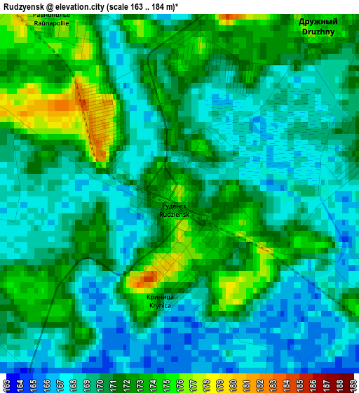
Below is the Elevation map of Rudzyensk, which displays elevation range with different colors. Scale of the first map is from 163 to 184 m (535 to 604 ft) with average elevation of 170.1 meters (=558 ft) [note 1]
These maps also provides idea of topography and contour of this city, they are displayed at different zoom levels. More info about maps, scale and edge coordinates you can find below images.
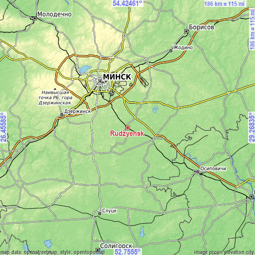
| \ | Map #1 | Topo.Map |
| Scale [m] | 163..184 m | × |
| Scale [ft] | 535..604 ft | × |
| Average | 170.1 m = 558 ft | × |
| Width | 5.8 km = 3.6 mi | 185.6 km = 115.3 mi |
| Height | 5.8 km = 3.6 mi | 185.6 km = 115.3 mi |
| ↑Max Latitude | 53.624371° | 54.42461° |
| Latitude at center | 53.5983° | 53.5983° |
| ↓Min Latitude | 53.572213° | 52.7555° |
| ← Min Longitude | 27.818155° | 26.45585° |
| Longitude center | 27.8621° | 27.8621° |
| →Max Longitude | 27.906045° | 29.26835° |
Nearby cities:
Cities around Rudzyensk sort by population:
• Mar’’ina Horka elevation 178 m
21.3 km,  117°
117°
• Druzhny 173 m
3.7 km,  39°
39°
• Hatava 193 m
25.2 km,  324°
324°
• Smilavichy 180 m
19.5 km,  30°
30°
• Michanovichi 193 m
19.2 km, 324°
• Svislach 175 m
6 km, 39°
• Prawdzinski 177 m
8.4 km,  194°
194°
• Zamostochye 190 m
24.6 km,  0°
0°
• Pryvol’ny 194 m
22.5 km,  348°
348°
• Blon’ 164 m
22 km,  111°
111°
• Luhavaya Slabada 181 m
20.5 km,  356°
356°
• Dukora 174 m
10.3 km, 29°
Multilingual:
 En español:
Rudzyensk elevación 176 m.
 En France:
Rudzyensk élévation 176 m.
 Auf Deutsch:
Rudzyensk höhe über dem Meeresspiegel ist 176 m.

Sources and notes:
- [note 1] Map square and city borders are not equal. Map elevation data is calculated only from area inside that square.
- [src 1] Elevation data from geonames database provided with same terms of usage.
- [src 2] The elevation map of Rudzyensk is generated using elevation data from NASA's 3 arcsec (90m) resolution SRTM data.
- [src 3] Base (background) map © OpenStreetMap contributors tiles are generated by Geofabrik and OpenTopoMap.
Copyright & License:
This Rudzyensk Elevation Map is licensed under CC BY-SA. You may reuse any part from this page, if you give a proper credit by linking to this URL:
 More info on terms of use page.