Cacoal elevation
Cacoal (Rondônia), Brazil elevation is 197 meters and Cacoal elevation in feet is 646 ft above sea level [src 1]. Cacoal is a populated place (feature code) with elevation that is 185 meters (607 ft) smaller than average city elevation in Brazil.
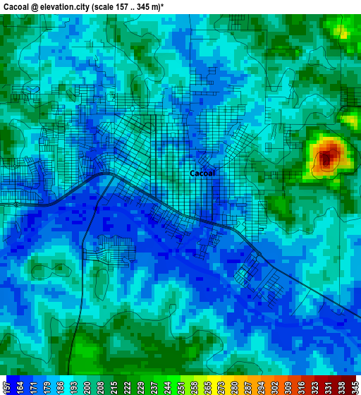
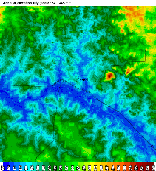
Below is the Elevation map of Cacoal, which displays elevation range with different colors. Scale of the first map is from 157 to 345 m (515 to 1132 ft) with average elevation of 192.1 meters (=630 ft) [note 1]
These maps also provides idea of topography and contour of this city, they are displayed at different zoom levels. More info about maps, scale and edge coordinates you can find below images.
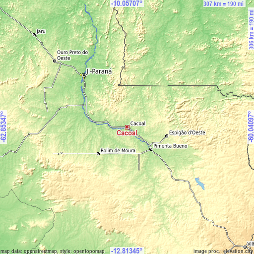
| \ | Map #1 | Map #2 | Topo.Map |
| Scale [m] | 157..345 m | 157..345 m | × |
| Scale [ft] | 515..1132 ft | 515..1132 ft | × |
| Average | 192.1 m = 630 ft | 208.9 m = 685 ft | × |
| Width | 9.58 km = 6 mi | 19.16 km = 11.9 mi | 306.5 km = 190.4 mi |
| Height | 9.58 km = 6 mi | 19.16 km = 11.9 mi | 306.5 km = 190.4 mi |
| ↑Max Latitude | -11.395534° | -11.352452° | -10.05707° |
| Latitude at center | -11.43861° | -11.43861° | -11.43861° |
| ↓Min Latitude | -11.481679° | -11.524742° | -12.81345° |
| ← Min Longitude | -61.491165° | -61.535111° | -62.85347° |
| Longitude center | -61.44722° | -61.44722° | -61.44722° |
| →Max Longitude | -61.403275° | -61.359329° | -60.04097° |
Nearby cities:
Cities around Cacoal sort by population:
• Porto Velho elevation 90 m
401.1 km,  317°
317°
• Ji Paraná 157 m
82.5 km, 318°
• Vilhena 591 m
202.4 km,  135°
135°
• Ariquemes 139 m
243.1 km,  314°
314°
• Pôsto Fiscal Rolim de Moura 159 m
203.8 km,  206°
206°
• Guajará Mirim 131 m
430.4 km,  279°
279°
• Jaru 159 m
157.3 km, 314°
• Aripuanã 144 m
267.8 km,  19°
19°
• Ouro Preto do Oeste 214 m
113.7 km, 312°
• Pimenta Bueno 183 m
37.9 km,  133°
133°
• Presidente Médici 181 m
57.5 km,  300°
300°
Multilingual:
 En español:
Cacoal elevación 197 m.
 En France:
Cacoal élévation 197 m.


Sources and notes:
- [note 1] Map square and city borders are not equal. Map elevation data is calculated only from area inside that square.
- [src 1] Elevation data from geonames database provided with same terms of usage.
- [src 2] The elevation map of Cacoal is generated using elevation data from NASA's 3 arcsec (90m) resolution SRTM data.
- [src 3] Base (background) map © OpenStreetMap contributors tiles are generated by Geofabrik and OpenTopoMap.
Copyright & License:
This Cacoal Elevation Map is licensed under CC BY-SA. You may reuse any part from this page, if you give a proper credit by linking to this URL:
 More info on terms of use page.