Alfredo Chaves elevation
Alfredo Chaves (Espírito Santo), Brazil elevation is 19 meters and Alfredo Chaves elevation in feet is 62 ft above sea level [src 1]. Alfredo Chaves is a populated place (feature code) with elevation that is 363 meters (1191 ft) smaller than average city elevation in Brazil.
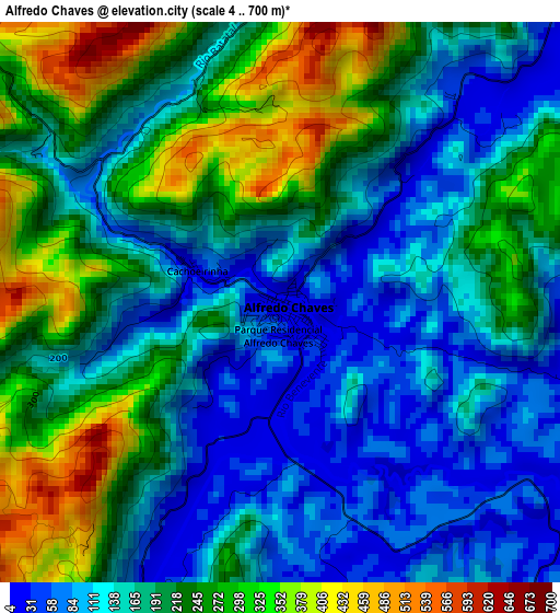
Below is the Elevation map of Alfredo Chaves, which displays elevation range with different colors. Scale of the first map is from 4 to 700 m (13 to 2297 ft) with average elevation of 187.4 meters (=615 ft) [note 1]
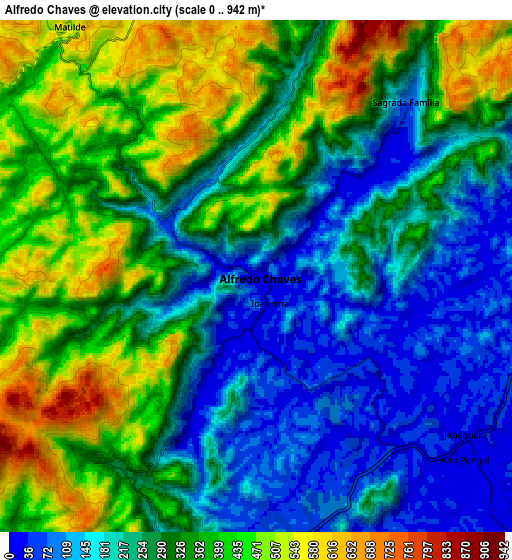
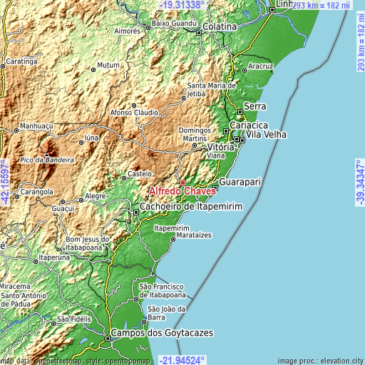
These maps also provides idea of topography and contour of this city, they are displayed at different zoom levels. More info about maps, scale and edge coordinates you can find below images.
| \ | Map #1 | Map #2 | Topo.Map |
| Scale [m] | 4..700 m | 0..942 m | × |
| Scale [ft] | 13..2297 ft | 0..3091 ft | × |
| Average | 187.4 m = 615 ft | 299 m = 981 ft | × |
| Width | 9.15 km = 5.7 mi | 18.29 km = 11.4 mi | 292.6 km = 181.8 mi |
| Height | 9.15 km = 5.7 mi | 18.29 km = 11.4 mi | 292.7 km = 181.9 mi |
| ↑Max Latitude | -20.593868° | -20.552726° | -19.31338° |
| Latitude at center | -20.635° | -20.635° | -20.635° |
| ↓Min Latitude | -20.67612° | -20.71723° | -21.94524° |
| ← Min Longitude | -40.793665° | -40.837611° | -42.15597° |
| Longitude center | -40.74972° | -40.74972° | -40.74972° |
| →Max Longitude | -40.705775° | -40.661829° | -39.34347° |
Nearby cities:
Cities around Alfredo Chaves sort by population:
• Cachoeiro de Itapemirim elevation 39 m
44.6 km,  237°
237°
• Guarapari 5 m
26.1 km,  99°
99°
• Viana 35 m
37.9 km,  44°
44°
• Marataizes 7 m
46.1 km,  189°
189°
• Castelo 129 m
45.4 km,  274°
274°
• Piúma 2 m
22.7 km,  172°
172°
• Itapemirim 9 m
42.7 km, 191°
• Rio Novo do Sul 68 m
31.9 km,  217°
217°
• Domingos Martins 525 m
31.6 km,  17°
17°
• Marechal Floriano 555 m
25.7 km, 15°
• Iconha 29 m
18.7 km,  199°
199°
• Vargem Alta 604 m
27.1 km,  261°
261°
Multilingual:
 En español:
Alfredo Chaves elevación 19 m.
 En France:
Alfredo Chaves élévation 19 m.
 Auf Deutsch:
Alfredo Chaves höhe über dem Meeresspiegel ist 19 m.

Sources and notes:
- [note 1] Map square and city borders are not equal. Map elevation data is calculated only from area inside that square.
- [src 1] Elevation data from geonames database provided with same terms of usage.
- [src 2] The elevation map of Alfredo Chaves is generated using elevation data from NASA's 3 arcsec (90m) resolution SRTM data.
- [src 3] Base (background) map © OpenStreetMap contributors tiles are generated by Geofabrik and OpenTopoMap.
Copyright & License:
This Alfredo Chaves Elevation Map is licensed under CC BY-SA. You may reuse any part from this page, if you give a proper credit by linking to this URL:
 More info on terms of use page.