Cachoeira do Sul elevation
Cachoeira do Sul (Rio Grande do Sul), Brazil elevation is 77 meters and Cachoeira do Sul elevation in feet is 253 ft above sea level [src 1]. Cachoeira do Sul is a populated place (feature code) with elevation that is 305 meters (1001 ft) smaller than average city elevation in Brazil.
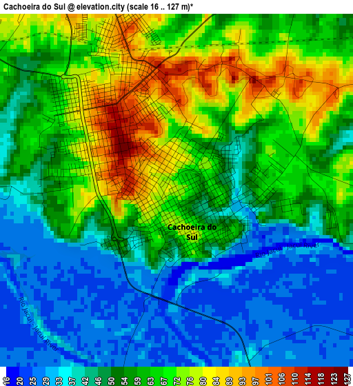
Below is the Elevation map of Cachoeira do Sul, which displays elevation range with different colors. Scale of the first map is from 16 to 127 m (52 to 417 ft) with average elevation of 55.1 meters (=181 ft) [note 1]
These maps also provides idea of topography and contour of this city, they are displayed at different zoom levels. More info about maps, scale and edge coordinates you can find below images.
| \ | Map #1 | Map #2 | Topo.Map |
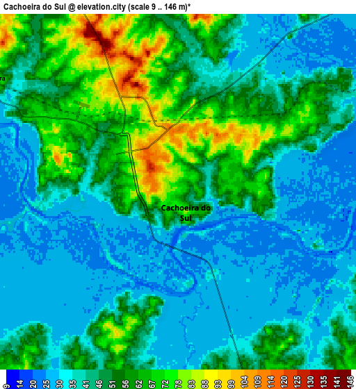
| Scale [m] | 16..127 m | 9..146 m | × |
| Scale [ft] | 52..417 ft | 30..479 ft | × |
| Average | 55.1 m = 181 ft | 46.7 m = 153 ft | × |
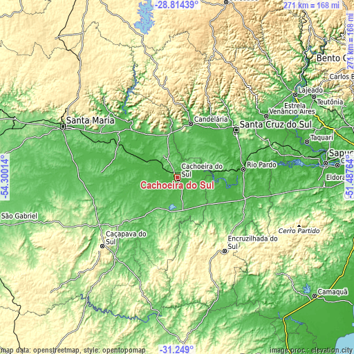
| Width | 8.46 km = 5.3 mi | 16.92 km = 10.5 mi | 270.7 km = 168.2 mi |
| Height | 8.46 km = 5.3 mi | 16.92 km = 10.5 mi | 270.7 km = 168.2 mi |
| ↑Max Latitude | -30.00112° | -29.963055° | -28.81439° |
| Latitude at center | -30.03917° | -30.03917° | -30.03917° |
| ↓Min Latitude | -30.077205° | -30.115226° | -31.249° |
| ← Min Longitude | -52.937835° | -52.981781° | -54.30014° |
| Longitude center | -52.89389° | -52.89389° | -52.89389° |
| →Max Longitude | -52.849945° | -52.805999° | -51.48764° |
Nearby cities:
Cities around Cachoeira do Sul sort by population:
• Santa Maria elevation 146 m
96.5 km,  294°
294°
• Santa Cruz do Sul 69 m
57.6 km,  51°
51°
• Lajeado 28 m
110.2 km, 54°
• Venâncio Aires 43 m
83.1 km, 54°
• Candelária 53 m
42.4 km,  13°
13°
• Taquari 57 m
102.7 km,  74°
74°
• Rio Pardo 36 m
50 km,  83°
83°
• Butiá 71 m
90.1 km,  95°
95°
• São Sepé 96 m
66 km,  258°
258°
• Caçapava do Sul 426 m
77.5 km,  227°
227°
• Encruzilhada do Sul 431 m
66.5 km,  147°
147°
• Pinheiros 107 m
32.4 km,  28°
28°
Multilingual:
 En español:
Cachoeira do Sul elevación 77 m.
 En France:
Cachoeira do Sul élévation 77 m.
 Auf Deutsch:
Cachoeira do Sul höhe über dem Meeresspiegel ist 77 m.

Sources and notes:
- [note 1] Map square and city borders are not equal. Map elevation data is calculated only from area inside that square.
- [src 1] Elevation data from geonames database provided with same terms of usage.
- [src 2] The elevation map of Cachoeira do Sul is generated using elevation data from NASA's 3 arcsec (90m) resolution SRTM data.
- [src 3] Base (background) map © OpenStreetMap contributors tiles are generated by Geofabrik and OpenTopoMap.
Copyright & License:
This Cachoeira do Sul Elevation Map is licensed under CC BY-SA. You may reuse any part from this page, if you give a proper credit by linking to this URL:
 More info on terms of use page.