Casimiro de Abreu elevation
Casimiro de Abreu (Rio de Janeiro), Brazil elevation is 23 meters and Casimiro de Abreu elevation in feet is 75 ft above sea level [src 1]. Casimiro de Abreu is a populated place (feature code) with elevation that is 359 meters (1178 ft) smaller than average city elevation in Brazil.
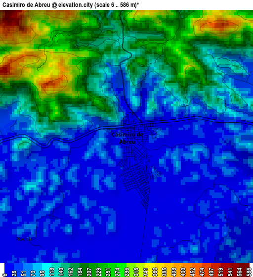
Below is the Elevation map of Casimiro de Abreu, which displays elevation range with different colors. Scale of the first map is from 6 to 586 m (20 to 1923 ft) with average elevation of 108.1 meters (=355 ft) [note 1]
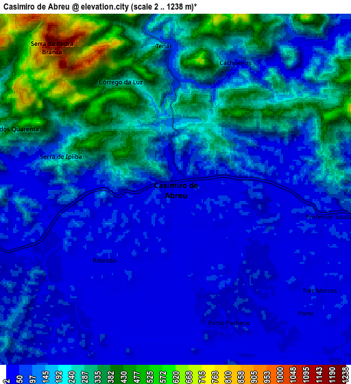
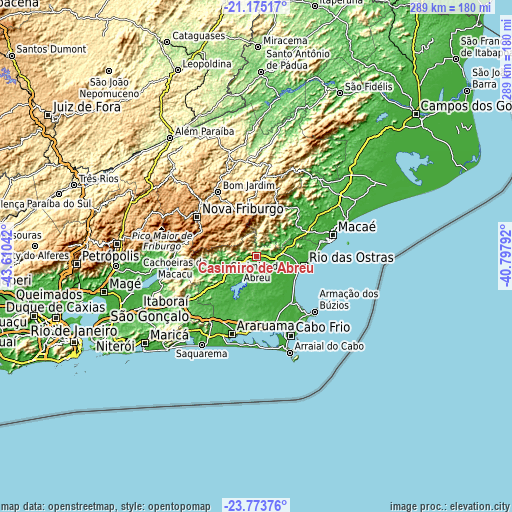
These maps also provides idea of topography and contour of this city, they are displayed at different zoom levels. More info about maps, scale and edge coordinates you can find below images.
| \ | Map #1 | Map #2 | Topo.Map |
| Scale [m] | 6..586 m | 2..1238 m | × |
| Scale [ft] | 20..1923 ft | 7..4062 ft | × |
| Average | 108.1 m = 355 ft | 161.5 m = 530 ft | × |
| Width | 9.03 km = 5.6 mi | 18.06 km = 11.2 mi | 288.9 km = 179.5 mi |
| Height | 9.03 km = 5.6 mi | 18.06 km = 11.2 mi | 289 km = 179.6 mi |
| ↑Max Latitude | -22.439948° | -22.399324° | -21.17517° |
| Latitude at center | -22.48056° | -22.48056° | -22.48056° |
| ↓Min Latitude | -22.52116° | -22.561748° | -23.77376° |
| ← Min Longitude | -42.248115° | -42.292061° | -43.61042° |
| Longitude center | -42.20417° | -42.20417° | -42.20417° |
| →Max Longitude | -42.160225° | -42.116279° | -40.79792° |
Nearby cities:
Cities around Casimiro de Abreu sort by population:
• Nova Friburgo elevation 858 m
40.2 km,  303°
303°
• Macaé 8 m
44.6 km,  76°
76°
• Araruama 20 m
45.9 km,  198°
198°
• Cabo Frio 13 m
48.8 km,  158°
158°
• Rio das Ostras 11 m
27.1 km,  100°
100°
• São Pedro da Aldeia 19 m
41.2 km,  165°
165°
• Cachoeiras de Macacu 63 m
46.2 km,  272°
272°
• Rio Bonito 67 m
48.7 km,  238°
238°
• Armação de Búzios 9 m
44.4 km,  131°
131°
• Silva Jardim 19 m
27 km,  225°
225°
• Cordeiro 491 m
52.8 km,  342°
342°
• Iguaba Grande 17 m
40 km,  183°
183°
Multilingual:
 En español:
Casimiro de Abreu elevación 23 m.
 En France:
Casimiro de Abreu élévation 23 m.
 Auf Deutsch:
Casimiro de Abreu höhe über dem Meeresspiegel ist 23 m.

Sources and notes:
- [note 1] Map square and city borders are not equal. Map elevation data is calculated only from area inside that square.
- [src 1] Elevation data from geonames database provided with same terms of usage.
- [src 2] The elevation map of Casimiro de Abreu is generated using elevation data from NASA's 3 arcsec (90m) resolution SRTM data.
- [src 3] Base (background) map © OpenStreetMap contributors tiles are generated by Geofabrik and OpenTopoMap.
Copyright & License:
This Casimiro de Abreu Elevation Map is licensed under CC BY-SA. You may reuse any part from this page, if you give a proper credit by linking to this URL:
 More info on terms of use page.