Cipó elevation
Cipó (Bahia), Brazil elevation is 132 meters and Cipó elevation in feet is 433 ft above sea level [src 1]. Cipó is a populated place (feature code) with elevation that is 250 meters (820 ft) smaller than average city elevation in Brazil.
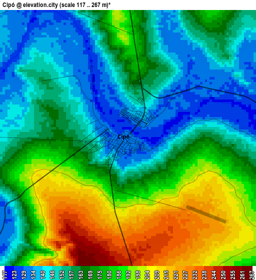
Below is the Elevation map of Cipó, which displays elevation range with different colors. Scale of the first map is from 117 to 267 m (384 to 876 ft) with average elevation of 169.2 meters (=555 ft) [note 1]
These maps also provides idea of topography and contour of this city, they are displayed at different zoom levels. More info about maps, scale and edge coordinates you can find below images.
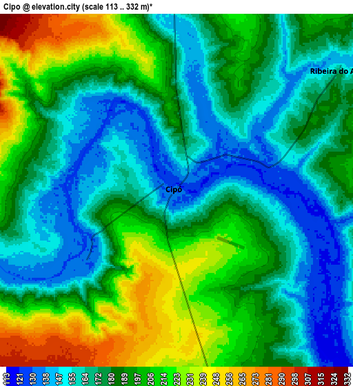
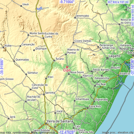
| \ | Map #1 | Map #2 | Topo.Map |
| Scale [m] | 117..267 m | 113..332 m | × |
| Scale [ft] | 384..876 ft | 371..1089 ft | × |
| Average | 169.2 m = 555 ft | 184.4 m = 605 ft | × |
| Width | 9.59 km = 6 mi | 19.18 km = 11.9 mi | 306.8 km = 190.6 mi |
| Height | 9.59 km = 6 mi | 19.18 km = 11.9 mi | 306.9 km = 190.7 mi |
| ↑Max Latitude | -11.056594° | -11.013461° | -9.71664° |
| Latitude at center | -11.09972° | -11.09972° | -11.09972° |
| ↓Min Latitude | -11.14284° | -11.185954° | -12.47628° |
| ← Min Longitude | -38.557555° | -38.601501° | -39.91986° |
| Longitude center | -38.51361° | -38.51361° | -38.51361° |
| →Max Longitude | -38.469665° | -38.425719° | -37.10736° |
Nearby cities:
Cities around Cipó sort by population:
• Tucano elevation 222 m
34.1 km,  297°
297°
• Tobias Barreto 164 m
57 km,  99°
99°
• Ribeira do Pombal 221 m
29.6 km,  355°
355°
• Rio Real 170 m
76.4 km,  124°
124°
• Cícero Dantas 399 m
57.4 km,  14°
14°
• Araci 257 m
55.8 km,  242°
242°
• Inhambupe 169 m
78.1 km,  167°
167°
• Olindina 166 m
35.6 km,  146°
146°
• Poço Verde 260 m
56.5 km,  39°
39°
• Nova Soure 164 m
15.2 km, 167°
• Itapicuru 117 m
38.9 km,  128°
128°
• Tomar do Geru 194 m
79.5 km,  112°
112°
Multilingual:
 En español:
Cipó elevación 132 m.
 En France:
Cipó élévation 132 m.


Sources and notes:
- [note 1] Map square and city borders are not equal. Map elevation data is calculated only from area inside that square.
- [src 1] Elevation data from geonames database provided with same terms of usage.
- [src 2] The elevation map of Cipó is generated using elevation data from NASA's 3 arcsec (90m) resolution SRTM data.
- [src 3] Base (background) map © OpenStreetMap contributors tiles are generated by Geofabrik and OpenTopoMap.
Copyright & License:
This Cipó Elevation Map is licensed under CC BY-SA. You may reuse any part from this page, if you give a proper credit by linking to this URL:
 More info on terms of use page.