Elói Mendes elevation
Elói Mendes (Minas Gerais), Brazil elevation is 910 meters and Elói Mendes elevation in feet is 2986 ft above sea level [src 1]. Elói Mendes is a populated place (feature code) with elevation that is 528 meters (1732 ft) bigger than average city elevation in Brazil.
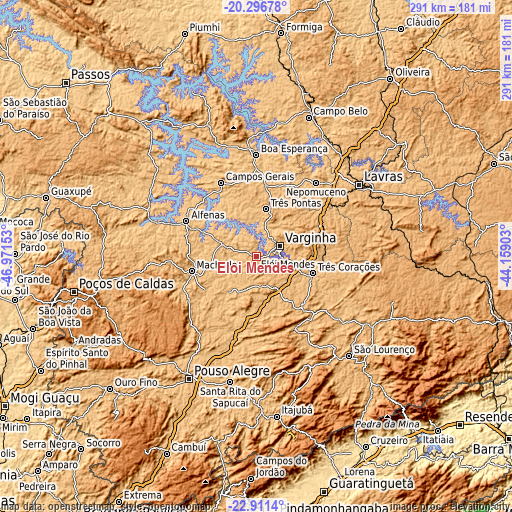
Below is the Elevation map of Elói Mendes, which displays elevation range with different colors. Scale of the first map is from 763 to 1011 m (2503 to 3317 ft) with average elevation of 867.1 meters (=2845 ft) [note 1]
These maps also provides idea of topography and contour of this city, they are displayed at different zoom levels. More info about maps, scale and edge coordinates you can find below images.


| \ | Map #1 | Map #2 | Topo.Map |
| Scale [m] | 763..1011 m | 757..1101 m | × |
| Scale [ft] | 2503..3317 ft | 2484..3612 ft | × |
| Average | 867.1 m = 2845 ft | 869.6 m = 2853 ft | × |
| Width | 9.09 km = 5.6 mi | 18.17 km = 11.3 mi | 290.7 km = 180.6 mi |
| Height | 9.09 km = 5.6 mi | 18.17 km = 11.3 mi | 290.7 km = 180.6 mi |
| ↑Max Latitude | -21.569138° | -21.528264° | -20.29678° |
| Latitude at center | -21.61° | -21.61° | -21.61° |
| ↓Min Latitude | -21.650851° | -21.69169° | -22.9114° |
| ← Min Longitude | -45.609225° | -45.653171° | -46.97153° |
| Longitude center | -45.56528° | -45.56528° | -45.56528° |
| →Max Longitude | -45.521335° | -45.477389° | -44.15903° |
Nearby cities:
Cities around Elói Mendes sort by population:
• Varginha elevation 887 m
15.4 km,  64°
64°
• Alfenas 887 m
44.3 km,  296°
296°
• Três Corações 884 m
33.7 km,  106°
106°
• Três Pontas 888 m
27.6 km,  11°
11°
• Machado 815 m
37.3 km,  258°
258°
• Campos Gerais 840 m
46.2 km,  334°
334°
• São Gonçalo do Sapucaí 866 m
31.5 km,  185°
185°
• Nepomuceno 849 m
54.1 km,  39°
39°
• Paraguaçu 825 m
19.1 km,  291°
291°
• Lambari 886 m
46.3 km,  151°
151°
• Campanha 920 m
30.4 km, 145°
• Cambuquira 951 m
38.7 km,  134°
134°
Multilingual:
 En español:
Elói Mendes elevación 910 m.
 En France:
Elói Mendes élévation 910 m.
 Auf Deutsch:
Elói Mendes höhe über dem Meeresspiegel ist 910 m.

Sources and notes:
- [note 1] Map square and city borders are not equal. Map elevation data is calculated only from area inside that square.
- [src 1] Elevation data from geonames database provided with same terms of usage.
- [src 2] The elevation map of Elói Mendes is generated using elevation data from NASA's 3 arcsec (90m) resolution SRTM data.
- [src 3] Base (background) map © OpenStreetMap contributors tiles are generated by Geofabrik and OpenTopoMap.
Copyright & License:
This Elói Mendes Elevation Map is licensed under CC BY-SA. You may reuse any part from this page, if you give a proper credit by linking to this URL:
 More info on terms of use page.