Encantado elevation
Encantado (Rio Grande do Sul), Brazil elevation is 73 meters and Encantado elevation in feet is 240 ft above sea level [src 1]. Encantado is a populated place (feature code) with elevation that is 309 meters (1014 ft) smaller than average city elevation in Brazil.
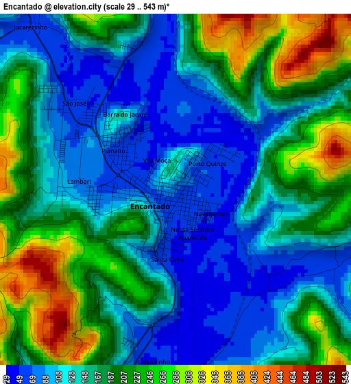
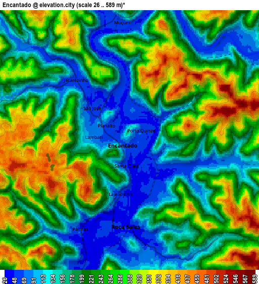
Below is the Elevation map of Encantado, which displays elevation range with different colors. Scale of the first map is from 29 to 543 m (95 to 1781 ft) with average elevation of 164.5 meters (=540 ft) [note 1]
These maps also provides idea of topography and contour of this city, they are displayed at different zoom levels. More info about maps, scale and edge coordinates you can find below images.
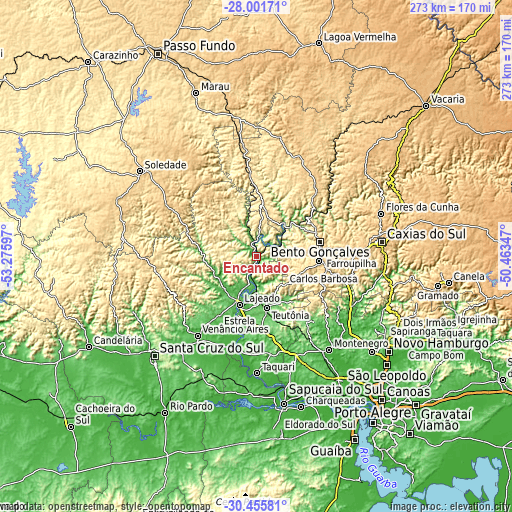
| \ | Map #1 | Map #2 | Topo.Map |
| Scale [m] | 29..543 m | 26..589 m | × |
| Scale [ft] | 95..1781 ft | 85..1932 ft | × |
| Average | 164.5 m = 540 ft | 220.7 m = 724 ft | × |
| Width | 8.53 km = 5.3 mi | 17.06 km = 10.6 mi | 272.9 km = 169.6 mi |
| Height | 8.53 km = 5.3 mi | 17.06 km = 10.6 mi | 272.9 km = 169.6 mi |
| ↑Max Latitude | -29.197756° | -29.159387° | -28.00171° |
| Latitude at center | -29.23611° | -29.23611° | -29.23611° |
| ↓Min Latitude | -29.27445° | -29.312776° | -30.45581° |
| ← Min Longitude | -51.913665° | -51.957611° | -53.27597° |
| Longitude center | -51.86972° | -51.86972° | -51.86972° |
| →Max Longitude | -51.825775° | -51.781829° | -50.46347° |
Nearby cities:
Cities around Encantado sort by population:
• Bento Gonçalves elevation 673 m
34.8 km,  78°
78°
• Lajeado 28 m
27.2 km,  199°
199°
• Farroupilha 773 m
50.7 km,  88°
88°
• Venâncio Aires 43 m
51.7 km,  217°
217°
• Garibaldi 607 m
32.7 km, 93°
• Teutônia 93 m
24.4 km,  165°
165°
• Guaporé 482 m
43.5 km,  357°
357°
• Veranópolis 669 m
45.6 km,  43°
43°
• Carlos Barbosa 680 m
36.2 km,  100°
100°
• São Sebastião do Caí 16 m
61.7 km,  129°
129°
• Nova Prata 658 m
56.3 km,  26°
26°
• Arroio do Meio 45 m
19.7 km, 201°
Multilingual:
 En español:
Encantado elevación 73 m.
 En France:
Encantado élévation 73 m.
 Auf Deutsch:
Encantado höhe über dem Meeresspiegel ist 73 m.

Sources and notes:
- [note 1] Map square and city borders are not equal. Map elevation data is calculated only from area inside that square.
- [src 1] Elevation data from geonames database provided with same terms of usage.
- [src 2] The elevation map of Encantado is generated using elevation data from NASA's 3 arcsec (90m) resolution SRTM data.
- [src 3] Base (background) map © OpenStreetMap contributors tiles are generated by Geofabrik and OpenTopoMap.
Copyright & License:
This Encantado Elevation Map is licensed under CC BY-SA. You may reuse any part from this page, if you give a proper credit by linking to this URL:
 More info on terms of use page.