Guaratuba elevation
Guaratuba (Paraná), Brazil elevation is 6 meters and Guaratuba elevation in feet is 20 ft above sea level [src 1]. Guaratuba is a populated place (feature code) with elevation that is 376 meters (1234 ft) smaller than average city elevation in Brazil.
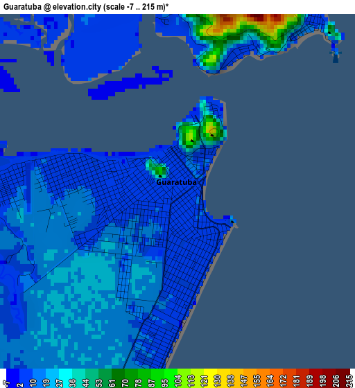
Below is the Elevation map of Guaratuba, which displays elevation range with different colors. Scale of the first map is from -7 to 215 m (-23 to 705 ft) with average elevation of 17.2 meters (=56 ft) [note 1]
These maps also provides idea of topography and contour of this city, they are displayed at different zoom levels. More info about maps, scale and edge coordinates you can find below images.
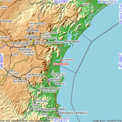
| \ | Map #1 | Map #2 | Topo.Map |
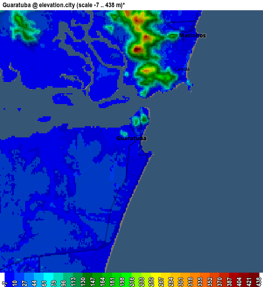
| Scale [m] | -7..215 m | -7..438 m | × |
| Scale [ft] | -23..705 ft | -23..1437 ft | × |
| Average | 17.2 m = 56 ft | 24.7 m = 81 ft | × |
| Width | 8.79 km = 5.5 mi | 17.58 km = 10.9 mi | 281.3 km = 174.8 mi |
| Height | 8.79 km = 5.5 mi | 17.58 km = 10.9 mi | 281.3 km = 174.8 mi |
| ↑Max Latitude | -25.843236° | -25.803679° | -24.61089° |
| Latitude at center | -25.88278° | -25.88278° | -25.88278° |
| ↓Min Latitude | -25.92231° | -25.961828° | -27.14111° |
| ← Min Longitude | -48.618665° | -48.662611° | -49.98097° |
| Longitude center | -48.57472° | -48.57472° | -48.57472° |
| →Max Longitude | -48.530775° | -48.486829° | -47.16847° |
Nearby cities:
Cities around Guaratuba sort by population:
• Joinville elevation 9 m
54.1 km,  209°
209°
• Paranaguá 12 m
41.1 km,  6°
6°
• São José dos Pinhais 882 m
74.6 km,  301°
301°
• Pinhais 887 m
78.8 km,  308°
308°
• Piraquara 910 m
69.6 km, 314°
• São Francisco do Sul 16 m
40.6 km,  188°
188°
• Campina Grande do Sul 885 m
80.3 km,  323°
323°
• Guaramirim 34 m
78.3 km, 213°
• Quatro Barras 932 m
76.4 km, 318°
• Antonina 9 m
52.3 km,  344°
344°
• Schroeder 46 m
77.1 km,  220°
220°
• Pontal do Paraná 7 m
24.1 km,  15°
15°
Multilingual:
 En español:
Guaratuba elevación 6 m.
 En France:
Guaratuba élévation 6 m.


Sources and notes:
- [note 1] Map square and city borders are not equal. Map elevation data is calculated only from area inside that square.
- [src 1] Elevation data from geonames database provided with same terms of usage.
- [src 2] The elevation map of Guaratuba is generated using elevation data from NASA's 3 arcsec (90m) resolution SRTM data.
- [src 3] Base (background) map © OpenStreetMap contributors tiles are generated by Geofabrik and OpenTopoMap.
Copyright & License:
This Guaratuba Elevation Map is licensed under CC BY-SA. You may reuse any part from this page, if you give a proper credit by linking to this URL:
 More info on terms of use page.