Içara elevation
Içara (Santa Catarina), Brazil elevation is 43 meters and Içara elevation in feet is 141 ft above sea level [src 1]. Içara is a populated place (feature code) with elevation that is 339 meters (1112 ft) smaller than average city elevation in Brazil.
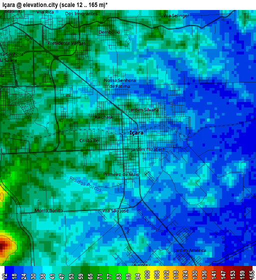
Below is the Elevation map of Içara, which displays elevation range with different colors. Scale of the first map is from 12 to 165 m (39 to 541 ft) with average elevation of 39.6 meters (=130 ft) [note 1]
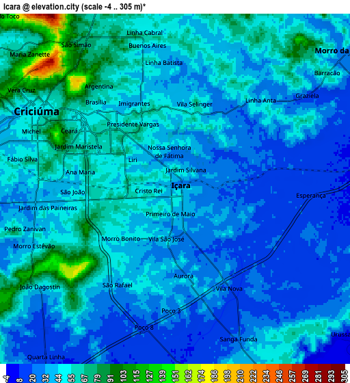
These maps also provides idea of topography and contour of this city, they are displayed at different zoom levels. More info about maps, scale and edge coordinates you can find below images.
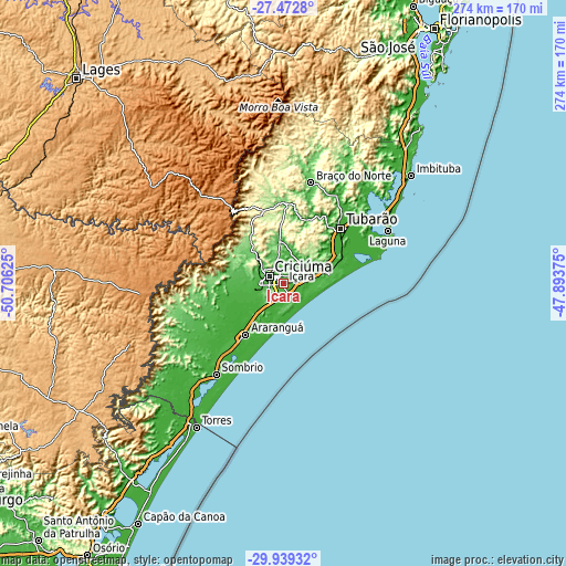
| \ | Map #1 | Map #2 | Topo.Map |
| Scale [m] | 12..165 m | -4..305 m | × |
| Scale [ft] | 39..541 ft | -13..1001 ft | × |
| Average | 39.6 m = 130 ft | 43.4 m = 142 ft | × |
| Width | 8.57 km = 5.3 mi | 17.14 km = 10.7 mi | 274.3 km = 170.4 mi |
| Height | 8.57 km = 5.3 mi | 17.14 km = 10.7 mi | 274.3 km = 170.4 mi |
| ↑Max Latitude | -28.674781° | -28.636219° | -27.4728° |
| Latitude at center | -28.71333° | -28.71333° | -28.71333° |
| ↓Min Latitude | -28.751864° | -28.790385° | -29.93932° |
| ← Min Longitude | -49.343945° | -49.387891° | -50.70625° |
| Longitude center | -49.3° | -49.3° | -49.3° |
| →Max Longitude | -49.256055° | -49.212109° | -47.89375° |
Nearby cities:
Cities around Içara sort by population:
• Criciúma elevation 50 m
7.9 km,  300°
300°
• Tubarão 7 m
39.6 km,  46°
46°
• Araranguá 5 m
31.2 km,  217°
217°
• Forquilhinha 28 m
17.2 km,  257°
257°
• Braço do Norte 69 m
50.5 km,  15°
15°
• Orleans 131 m
39.4 km,  1°
1°
• Morro da Fumaça 21 m
11.2 km, 51°
• Cocal 73 m
12.5 km,  347°
347°
• Jaguaruna 16 m
28.7 km,  69°
69°
• Urussanga 49 m
21.8 km, 354°
• Lauro Muller 218 m
36.9 km, 345°
• Siderópolis 115 m
17.7 km,  316°
316°
Multilingual:
 En español:
Içara elevación 43 m.
 En France:
Içara élévation 43 m.


Sources and notes:
- [note 1] Map square and city borders are not equal. Map elevation data is calculated only from area inside that square.
- [src 1] Elevation data from geonames database provided with same terms of usage.
- [src 2] The elevation map of Içara is generated using elevation data from NASA's 3 arcsec (90m) resolution SRTM data.
- [src 3] Base (background) map © OpenStreetMap contributors tiles are generated by Geofabrik and OpenTopoMap.
Copyright & License:
This Içara Elevation Map is licensed under CC BY-SA. You may reuse any part from this page, if you give a proper credit by linking to this URL:
 More info on terms of use page.