Iporã elevation
Iporã (Paraná), Brazil elevation is 377 meters and Iporã elevation in feet is 1237 ft above sea level [src 1]. Iporã is a populated place (feature code) with elevation that is 5 meters (16 ft) smaller than average city elevation in Brazil.
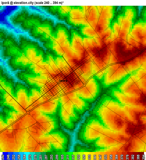
Below is the Elevation map of Iporã, which displays elevation range with different colors. Scale of the first map is from 240 to 394 m (787 to 1293 ft) with average elevation of 329.6 meters (=1081 ft) [note 1]
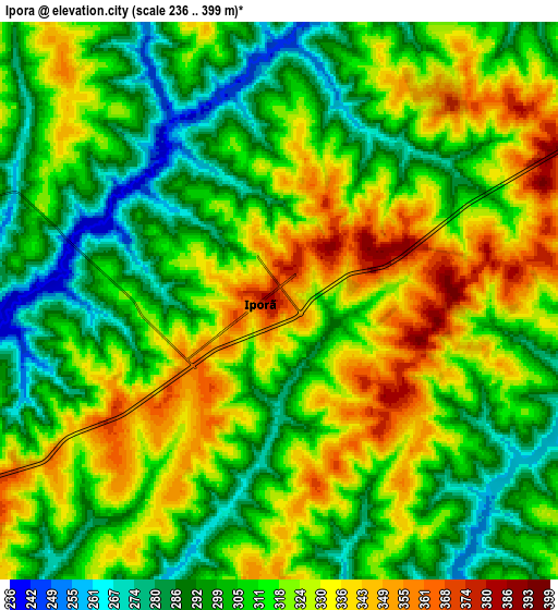
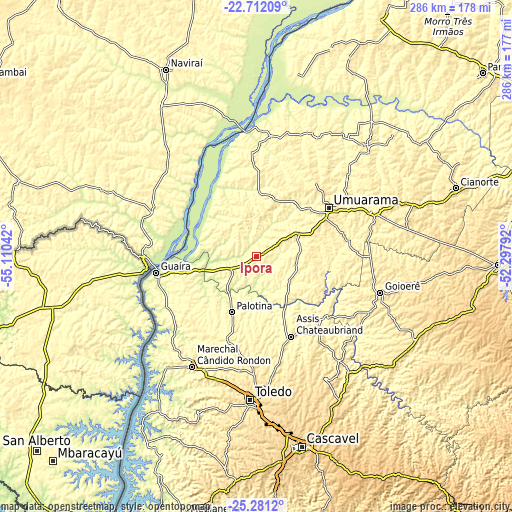
These maps also provides idea of topography and contour of this city, they are displayed at different zoom levels. More info about maps, scale and edge coordinates you can find below images.
| \ | Map #1 | Map #2 | Topo.Map |
| Scale [m] | 240..394 m | 236..399 m | × |
| Scale [ft] | 787..1293 ft | 774..1309 ft | × |
| Average | 329.6 m = 1081 ft | 313.8 m = 1030 ft | × |
| Width | 8.93 km = 5.5 mi | 17.85 km = 11.1 mi | 285.7 km = 177.5 mi |
| Height | 8.93 km = 5.5 mi | 17.85 km = 11.1 mi | 285.7 km = 177.5 mi |
| ↑Max Latitude | -23.962909° | -23.922745° | -22.71209° |
| Latitude at center | -24.00306° | -24.00306° | -24.00306° |
| ↓Min Latitude | -24.043199° | -24.083325° | -25.2812° |
| ← Min Longitude | -53.748115° | -53.792061° | -55.11042° |
| Longitude center | -53.70417° | -53.70417° | -53.70417° |
| →Max Longitude | -53.660225° | -53.616279° | -52.29792° |
Nearby cities:
Cities around Iporã sort by population:
• Toledo elevation 562 m
79.1 km,  182°
182°
• Umuarama 443 m
46.7 km,  55°
55°
• Marechal Cândido Rondon 425 m
71.1 km,  210°
210°
• Palotina 339 m
34.1 km,  203°
203°
• Cruzeiro do Oeste 465 m
68.6 km,  69°
69°
• Corbélia 639 m
97.2 km,  155°
155°
• Altãnia 353 m
24.6 km,  305°
305°
• Tapejara 518 m
89.7 km, 70°
• Alto Piquiri 424 m
26.9 km,  95°
95°
• Iguatemi 342 m
94.3 km,  292°
292°
• Eldorado 350 m
63.6 km, 292°
• Moreira Sales 463 m
71.1 km, 95°
Multilingual:
 En español:
Iporã elevación 377 m.
 En France:
Iporã élévation 377 m.


Sources and notes:
- [note 1] Map square and city borders are not equal. Map elevation data is calculated only from area inside that square.
- [src 1] Elevation data from geonames database provided with same terms of usage.
- [src 2] The elevation map of Iporã is generated using elevation data from NASA's 3 arcsec (90m) resolution SRTM data.
- [src 3] Base (background) map © OpenStreetMap contributors tiles are generated by Geofabrik and OpenTopoMap.
Copyright & License:
This Iporã Elevation Map is licensed under CC BY-SA. You may reuse any part from this page, if you give a proper credit by linking to this URL:
 More info on terms of use page.