Itacaré elevation
Itacaré (Bahia), Brazil elevation is 23 meters and Itacaré elevation in feet is 75 ft above sea level [src 1]. Itacaré is a populated place (feature code) with elevation that is 359 meters (1178 ft) smaller than average city elevation in Brazil.
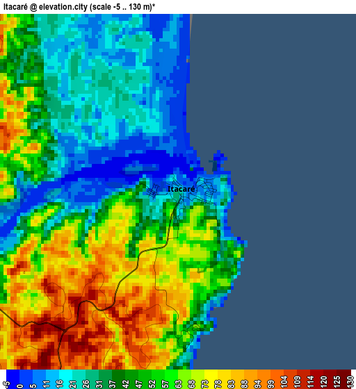
Below is the Elevation map of Itacaré, which displays elevation range with different colors. Scale of the first map is from -5 to 130 m (-16 to 427 ft) with average elevation of 48.2 meters (=158 ft) [note 1]
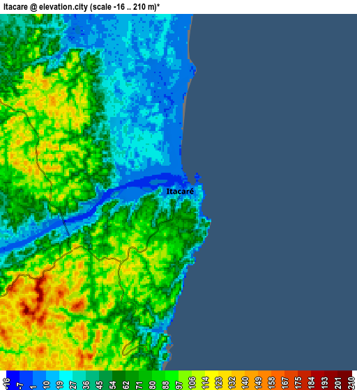
These maps also provides idea of topography and contour of this city, they are displayed at different zoom levels. More info about maps, scale and edge coordinates you can find below images.
| \ | Map #1 | Map #2 | Topo.Map |
| Scale [m] | -5..130 m | -16..210 m | × |
| Scale [ft] | -16..427 ft | -52..689 ft | × |
| Average | 48.2 m = 158 ft | 67 m = 220 ft | × |
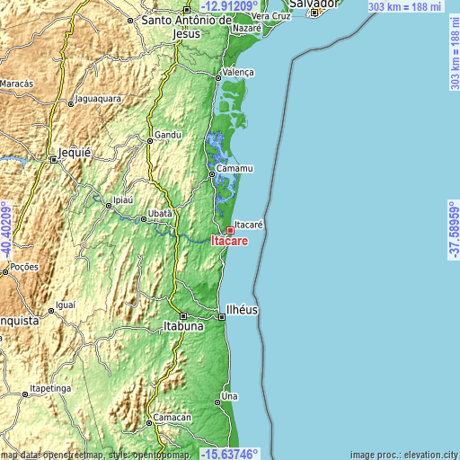
| Width | 9.47 km = 5.9 mi | 18.94 km = 11.8 mi | 303 km = 188.3 mi |
| Height | 9.47 km = 5.9 mi | 18.94 km = 11.8 mi | 303.1 km = 188.3 mi |
| ↑Max Latitude | -14.236308° | -14.193709° | -12.91209° |
| Latitude at center | -14.2789° | -14.2789° | -14.2789° |
| ↓Min Latitude | -14.321484° | -14.364059° | -15.63746° |
| ← Min Longitude | -39.039785° | -39.083731° | -40.40209° |
| Longitude center | -38.99584° | -38.99584° | -38.99584° |
| →Max Longitude | -38.951895° | -38.907949° | -37.58959° |
Nearby cities:
Cities around Itacaré sort by population:
• Itabuna elevation 69 m
64.1 km,  208°
208°
• Ilhéus 26 m
57.4 km,  184°
184°
• Coaraci 206 m
72.1 km,  236°
236°
• Ubaitaba 47 m
35.5 km,  263°
263°
• Uruçuca 95 m
46.8 km,  221°
221°
• Ibirataia 151 m
73.4 km,  288°
288°
• Ituberá 7 m
62.6 km,  344°
344°
• Ubatã 112 m
57.7 km,  277°
277°
• Itajuípe 94 m
60.3 km, 222°
• Camamu 37 m
38.9 km, 342°
• Ibirapitanga 109 m
42.7 km, 287°
• Maraú 33 m
19.6 km,  353°
353°
Multilingual:
 En español:
Itacaré elevación 23 m.
 En France:
Itacaré élévation 23 m.


Sources and notes:
- [note 1] Map square and city borders are not equal. Map elevation data is calculated only from area inside that square.
- [src 1] Elevation data from geonames database provided with same terms of usage.
- [src 2] The elevation map of Itacaré is generated using elevation data from NASA's 3 arcsec (90m) resolution SRTM data.
- [src 3] Base (background) map © OpenStreetMap contributors tiles are generated by Geofabrik and OpenTopoMap.
Copyright & License:
This Itacaré Elevation Map is licensed under CC BY-SA. You may reuse any part from this page, if you give a proper credit by linking to this URL:
 More info on terms of use page.