Itajaí elevation
Itajaí (Santa Catarina), Brazil elevation is 6 meters and Itajaí elevation in feet is 20 ft above sea level [src 1]. Itajaí is a populated place (feature code) with elevation that is 376 meters (1234 ft) smaller than average city elevation in Brazil.
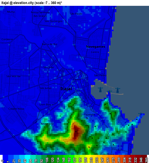
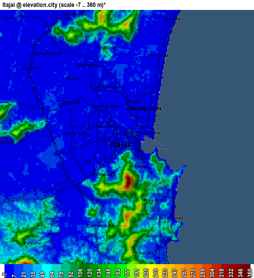
Below is the Elevation map of Itajaí, which displays elevation range with different colors. Scale of the first map is from -7 to 360 m (-23 to 1181 ft) with average elevation of 25.6 meters (=84 ft) [note 1]
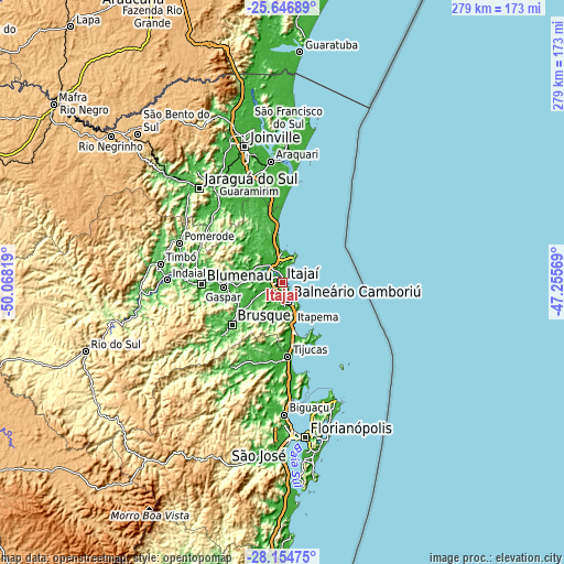
These maps also provides idea of topography and contour of this city, they are displayed at different zoom levels. More info about maps, scale and edge coordinates you can find below images.
| \ | Map #1 | Map #2 | Topo.Map |
| Scale [m] | -7..360 m | -7..360 m | × |
| Scale [ft] | -23..1181 ft | -23..1181 ft | × |
| Average | 25.6 m = 84 ft | 30.7 m = 101 ft | × |
| Width | 8.71 km = 5.4 mi | 17.43 km = 10.8 mi | 278.8 km = 173.2 mi |
| Height | 8.71 km = 5.4 mi | 17.43 km = 10.8 mi | 278.9 km = 173.3 mi |
| ↑Max Latitude | -26.868586° | -26.829378° | -25.64689° |
| Latitude at center | -26.90778° | -26.90778° | -26.90778° |
| ↓Min Latitude | -26.946961° | -26.986128° | -28.15475° |
| ← Min Longitude | -48.705885° | -48.749831° | -50.06819° |
| Longitude center | -48.66194° | -48.66194° | -48.66194° |
| →Max Longitude | -48.617995° | -48.574049° | -47.25569° |
Nearby cities:
Cities around Itajaí sort by population:
• Blumenau elevation 20 m
40.1 km,  268°
268°
• Brusque 22 m
32.6 km,  229°
229°
• Balneário Camboriú 12 m
9.6 km,  163°
163°
• Navegantes 7 m
1.3 km,  37°
37°
• Itapema 4 m
20.9 km,  166°
166°
• Gaspar 12 m
29.6 km,  264°
264°
• Tijucas 5 m
37.2 km,  175°
175°
• Pomerode 64 m
54.4 km,  289°
289°
• Penha 24 m
15.5 km,  5°
5°
• Barra Velha 14 m
30.7 km,  355°
355°
• Porto Belo 3 m
29.8 km, 158°
• São João Batista 32 m
45 km,  204°
204°
Multilingual:
 En español:
Itajaí elevación 6 m.
 En France:
Itajaí élévation 6 m.


Sources and notes:
- [note 1] Map square and city borders are not equal. Map elevation data is calculated only from area inside that square.
- [src 1] Elevation data from geonames database provided with same terms of usage.
- [src 2] The elevation map of Itajaí is generated using elevation data from NASA's 3 arcsec (90m) resolution SRTM data.
- [src 3] Base (background) map © OpenStreetMap contributors tiles are generated by Geofabrik and OpenTopoMap.
Copyright & License:
This Itajaí Elevation Map is licensed under CC BY-SA. You may reuse any part from this page, if you give a proper credit by linking to this URL:
 More info on terms of use page.