Itanhandu elevation
Itanhandu (Minas Gerais), Brazil elevation is 899 meters and Itanhandu elevation in feet is 2949 ft above sea level [src 1]. Itanhandu is a populated place (feature code) with elevation that is 517 meters (1696 ft) bigger than average city elevation in Brazil.
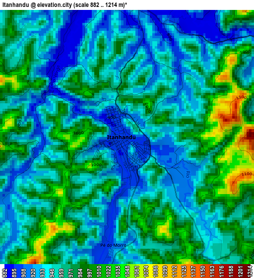
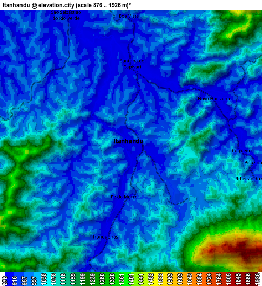
Below is the Elevation map of Itanhandu, which displays elevation range with different colors. Scale of the first map is from 882 to 1214 m (2894 to 3983 ft) with average elevation of 961.3 meters (=3154 ft) [note 1]
These maps also provides idea of topography and contour of this city, they are displayed at different zoom levels. More info about maps, scale and edge coordinates you can find below images.
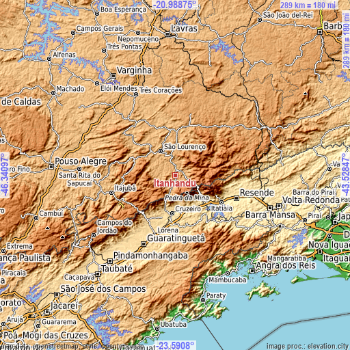
| \ | Map #1 | Map #2 | Topo.Map |
| Scale [m] | 882..1214 m | 876..1926 m | × |
| Scale [ft] | 2894..3983 ft | 2874..6319 ft | × |
| Average | 961.3 m = 3154 ft | 1028.7 m = 3375 ft | × |
| Width | 9.04 km = 5.6 mi | 18.08 km = 11.2 mi | 289.3 km = 179.8 mi |
| Height | 9.04 km = 5.6 mi | 18.08 km = 11.2 mi | 289.3 km = 179.8 mi |
| ↑Max Latitude | -22.255164° | -22.214487° | -20.98875° |
| Latitude at center | -22.29583° | -22.29583° | -22.29583° |
| ↓Min Latitude | -22.336484° | -22.377126° | -23.5908° |
| ← Min Longitude | -44.978665° | -45.022611° | -46.34097° |
| Longitude center | -44.93472° | -44.93472° | -44.93472° |
| →Max Longitude | -44.890775° | -44.846829° | -43.52847° |
Nearby cities:
Cities around Itanhandu sort by population:
• Resende elevation 408 m
53.7 km,  110°
110°
• Itajubá 858 m
55.2 km,  254°
254°
• Lorena 529 m
52.2 km,  201°
201°
• Cruzeiro 545 m
31.1 km,  186°
186°
• São Lourenço 884 m
23.5 km,  328°
328°
• Caxambu 908 m
35.4 km,  0°
0°
• Piquete 642 m
43.2 km,  215°
215°
• Baependi 903 m
37.7 km,  7°
7°
• Cruzília 1086 m
52.5 km, 14°
• Passa Quatro 924 m
11 km, 197°
• Itatiaia 406 m
44.2 km,  120°
120°
• Conceição do Rio Verde 884 m
48.7 km,  341°
341°
Multilingual:
 En español:
Itanhandu elevación 899 m.
 En France:
Itanhandu élévation 899 m.
 Auf Deutsch:
Itanhandu höhe über dem Meeresspiegel ist 899 m.

Sources and notes:
- [note 1] Map square and city borders are not equal. Map elevation data is calculated only from area inside that square.
- [src 1] Elevation data from geonames database provided with same terms of usage.
- [src 2] The elevation map of Itanhandu is generated using elevation data from NASA's 3 arcsec (90m) resolution SRTM data.
- [src 3] Base (background) map © OpenStreetMap contributors tiles are generated by Geofabrik and OpenTopoMap.
Copyright & License:
This Itanhandu Elevation Map is licensed under CC BY-SA. You may reuse any part from this page, if you give a proper credit by linking to this URL:
 More info on terms of use page.