Itapecerica elevation
Itapecerica (Minas Gerais), Brazil elevation is 833 meters and Itapecerica elevation in feet is 2733 ft above sea level [src 1]. Itapecerica is a populated place (feature code) with elevation that is 451 meters (1480 ft) bigger than average city elevation in Brazil.
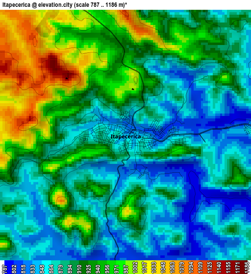
Below is the Elevation map of Itapecerica, which displays elevation range with different colors. Scale of the first map is from 787 to 1186 m (2582 to 3891 ft) with average elevation of 907.6 meters (=2978 ft) [note 1]
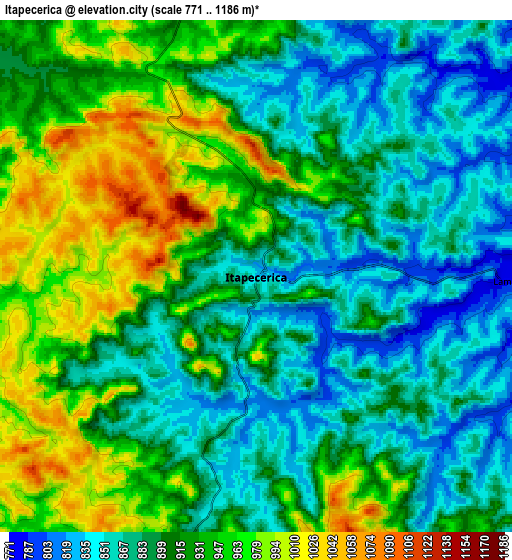
These maps also provides idea of topography and contour of this city, they are displayed at different zoom levels. More info about maps, scale and edge coordinates you can find below images.
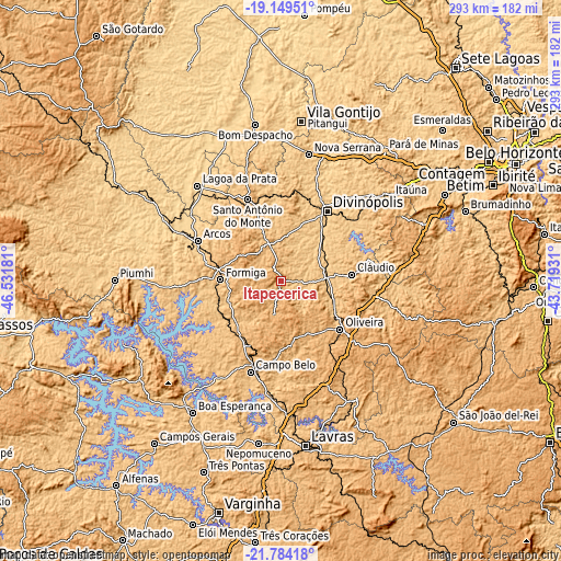
| \ | Map #1 | Map #2 | Topo.Map |
| Scale [m] | 787..1186 m | 771..1186 m | × |
| Scale [ft] | 2582..3891 ft | 2530..3891 ft | × |
| Average | 907.6 m = 2978 ft | 910.6 m = 2988 ft | × |
| Width | 9.16 km = 5.7 mi | 18.31 km = 11.4 mi | 292.9 km = 182 mi |
| Height | 9.16 km = 5.7 mi | 18.31 km = 11.4 mi | 293 km = 182.1 mi |
| ↑Max Latitude | -20.431325° | -20.390138° | -19.14951° |
| Latitude at center | -20.4725° | -20.4725° | -20.4725° |
| ↓Min Latitude | -20.513664° | -20.554817° | -21.78418° |
| ← Min Longitude | -45.169505° | -45.213451° | -46.53181° |
| Longitude center | -45.12556° | -45.12556° | -45.12556° |
| →Max Longitude | -45.081615° | -45.037669° | -43.71931° |
Nearby cities:
Cities around Itapecerica sort by population:
• Divinópolis elevation 747 m
44 km,  33°
33°
• Itaúna 848 m
72.3 km,  52°
52°
• Formiga 841 m
31.4 km,  271°
271°
• Campo Belo 854 m
49.8 km,  198°
198°
• Lagoa da Prata 662 m
66.4 km,  318°
318°
• Oliveira 985 m
39.8 km,  128°
128°
• Arcos 737 m
48.1 km,  296°
296°
• Santo Antônio do Monte 938 m
46.3 km,  337°
337°
• Cláudio 861 m
37.6 km,  85°
85°
• Perdões 842 m
68.8 km,  177°
177°
• Santo Antônio do Amparo 1013 m
56.9 km,  157°
157°
• Carmo do Cajuru 756 m
48.9 km, 49°
Multilingual:
 En español:
Itapecerica elevación 833 m.
 En France:
Itapecerica élévation 833 m.
 Auf Deutsch:
Itapecerica höhe über dem Meeresspiegel ist 833 m.

Sources and notes:
- [note 1] Map square and city borders are not equal. Map elevation data is calculated only from area inside that square.
- [src 1] Elevation data from geonames database provided with same terms of usage.
- [src 2] The elevation map of Itapecerica is generated using elevation data from NASA's 3 arcsec (90m) resolution SRTM data.
- [src 3] Base (background) map © OpenStreetMap contributors tiles are generated by Geofabrik and OpenTopoMap.
Copyright & License:
This Itapecerica Elevation Map is licensed under CC BY-SA. You may reuse any part from this page, if you give a proper credit by linking to this URL:
 More info on terms of use page.