Itaperuçu elevation
Itaperuçu (Paraná), Brazil elevation is 978 meters and Itaperuçu elevation in feet is 3209 ft above sea level [src 1]. Itaperuçu is a populated place (feature code) with elevation that is 596 meters (1955 ft) bigger than average city elevation in Brazil.
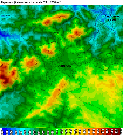
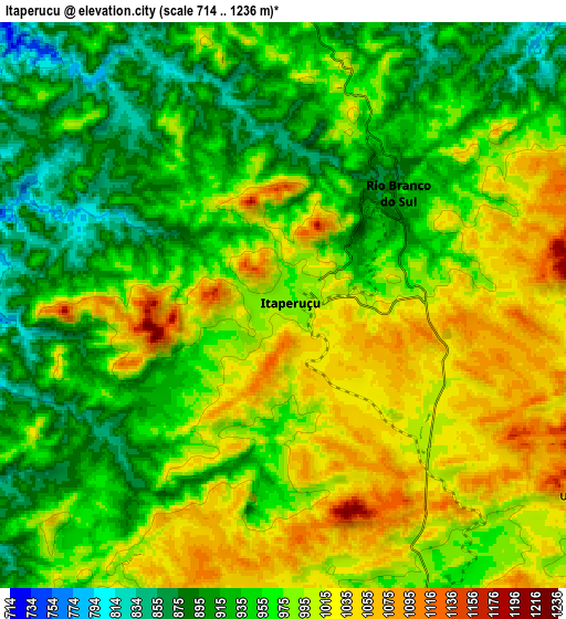
Below is the Elevation map of Itaperuçu, which displays elevation range with different colors. Scale of the first map is from 824 to 1236 m (2703 to 4055 ft) with average elevation of 994.3 meters (=3262 ft) [note 1]
These maps also provides idea of topography and contour of this city, they are displayed at different zoom levels. More info about maps, scale and edge coordinates you can find below images.
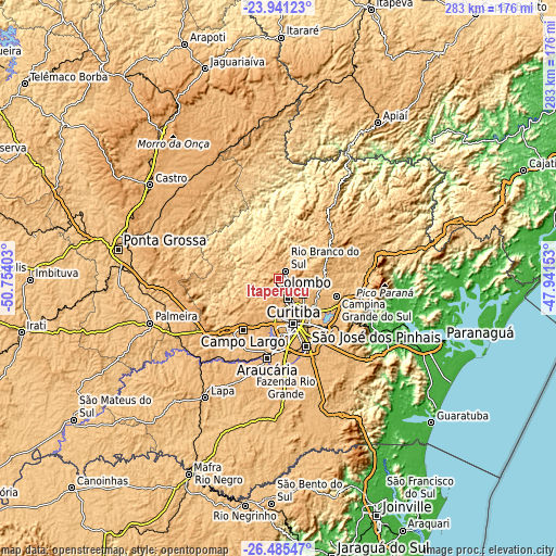
| \ | Map #1 | Map #2 | Topo.Map |
| Scale [m] | 824..1236 m | 714..1236 m | × |
| Scale [ft] | 2703..4055 ft | 2343..4055 ft | × |
| Average | 994.3 m = 3262 ft | 969.8 m = 3182 ft | × |
| Width | 8.84 km = 5.5 mi | 17.68 km = 11 mi | 282.9 km = 175.8 mi |
| Height | 8.84 km = 5.5 mi | 17.68 km = 11 mi | 282.9 km = 175.8 mi |
| ↑Max Latitude | -25.180237° | -25.140461° | -23.94123° |
| Latitude at center | -25.22° | -25.22° | -25.22° |
| ↓Min Latitude | -25.25975° | -25.299487° | -26.48547° |
| ← Min Longitude | -49.391725° | -49.435671° | -50.75403° |
| Longitude center | -49.34778° | -49.34778° | -49.34778° |
| →Max Longitude | -49.303835° | -49.259889° | -47.94153° |
Nearby cities:
Cities around Itaperuçu sort by population:
• Curitiba elevation 924 m
24.3 km,  161°
161°
• Colombo 1007 m
14.8 km,  122°
122°
• São José dos Pinhais 882 m
37.2 km, 157°
• Pinhais 887 m
29.5 km,  148°
148°
• Araucária 886 m
42 km,  188°
188°
• Campo Largo 965 m
32.3 km,  214°
214°
• Almirante Tamandaré 956 m
12.2 km, 161°
• Piraquara 910 m
37.4 km,  131°
131°
• Campina Grande do Sul 885 m
30.9 km,  107°
107°
• Rio Branco do Sul 901 m
4.7 km,  45°
45°
• Quatro Barras 932 m
31.7 km, 120°
• Antonina 9 m
68 km, 109°
Multilingual:
 En español:
Itaperuçu elevación 978 m.
 En France:
Itaperuçu élévation 978 m.
 Auf Deutsch:
Itaperuçu höhe über dem Meeresspiegel ist 978 m.

Sources and notes:
- [note 1] Map square and city borders are not equal. Map elevation data is calculated only from area inside that square.
- [src 1] Elevation data from geonames database provided with same terms of usage.
- [src 2] The elevation map of Itaperuçu is generated using elevation data from NASA's 3 arcsec (90m) resolution SRTM data.
- [src 3] Base (background) map © OpenStreetMap contributors tiles are generated by Geofabrik and OpenTopoMap.
Copyright & License:
This Itaperuçu Elevation Map is licensed under CC BY-SA. You may reuse any part from this page, if you give a proper credit by linking to this URL:
 More info on terms of use page.