Itororó elevation
Itororó (Bahia), Brazil elevation is 253 meters and Itororó elevation in feet is 830 ft above sea level [src 1]. Itororó is a populated place (feature code) with elevation that is 129 meters (423 ft) smaller than average city elevation in Brazil.
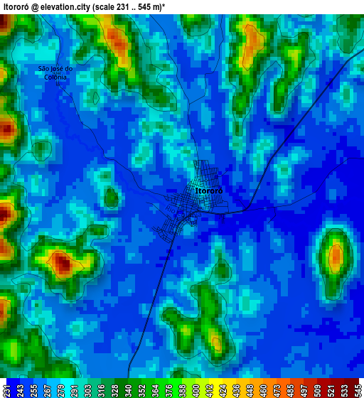
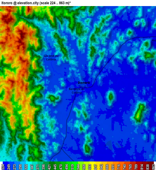
Below is the Elevation map of Itororó, which displays elevation range with different colors. Scale of the first map is from 231 to 545 m (758 to 1788 ft) with average elevation of 283.8 meters (=931 ft) [note 1]
These maps also provides idea of topography and contour of this city, they are displayed at different zoom levels. More info about maps, scale and edge coordinates you can find below images.
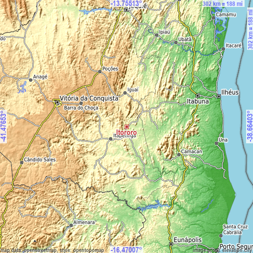
| \ | Map #1 | Map #2 | Topo.Map |
| Scale [m] | 231..545 m | 224..863 m | × |
| Scale [ft] | 758..1788 ft | 735..2831 ft | × |
| Average | 283.8 m = 931 ft | 358.2 m = 1175 ft | × |
| Width | 9.43 km = 5.9 mi | 18.87 km = 11.7 mi | 301.9 km = 187.6 mi |
| Height | 9.43 km = 5.9 mi | 18.87 km = 11.7 mi | 301.9 km = 187.6 mi |
| ↑Max Latitude | -15.074511° | -15.032074° | -13.75513° |
| Latitude at center | -15.11694° | -15.11694° | -15.11694° |
| ↓Min Latitude | -15.15936° | -15.201772° | -16.47007° |
| ← Min Longitude | -40.114225° | -40.158171° | -41.47653° |
| Longitude center | -40.07028° | -40.07028° | -40.07028° |
| →Max Longitude | -40.026335° | -39.982389° | -38.66403° |
Nearby cities:
Cities around Itororó sort by population:
• Vitória da Conquista elevation 876 m
87.2 km,  288°
288°
• Itapetinga 282 m
24 km,  232°
232°
• Poções 764 m
72.6 km,  334°
334°
• Coaraci 206 m
76.9 km,  46°
46°
• Itambé 357 m
61.1 km,  256°
256°
• Ibicaraí 163 m
58.9 km,  61°
61°
• Buerarema 111 m
84.6 km,  78°
78°
• Itajuípe 94 m
89.2 km, 56°
• Iguaí 354 m
40.1 km,  357°
357°
• Itarantim 255 m
60.4 km,  179°
179°
• Ibicuí 362 m
31.9 km,  16°
16°
• Pau Brasil 180 m
59.3 km,  130°
130°
Multilingual:
 En español:
Itororó elevación 253 m.
 En France:
Itororó élévation 253 m.


Sources and notes:
- [note 1] Map square and city borders are not equal. Map elevation data is calculated only from area inside that square.
- [src 1] Elevation data from geonames database provided with same terms of usage.
- [src 2] The elevation map of Itororó is generated using elevation data from NASA's 3 arcsec (90m) resolution SRTM data.
- [src 3] Base (background) map © OpenStreetMap contributors tiles are generated by Geofabrik and OpenTopoMap.
Copyright & License:
This Itororó Elevation Map is licensed under CC BY-SA. You may reuse any part from this page, if you give a proper credit by linking to this URL:
 More info on terms of use page.