Laje elevation
Laje (Bahia, Campo Formoso), Brazil elevation is 576 meters and Laje elevation in feet is 1890 ft above sea level [src 1]. Laje is a populated place (feature code) with elevation that is 194 meters (636 ft) bigger than average city elevation in Brazil.
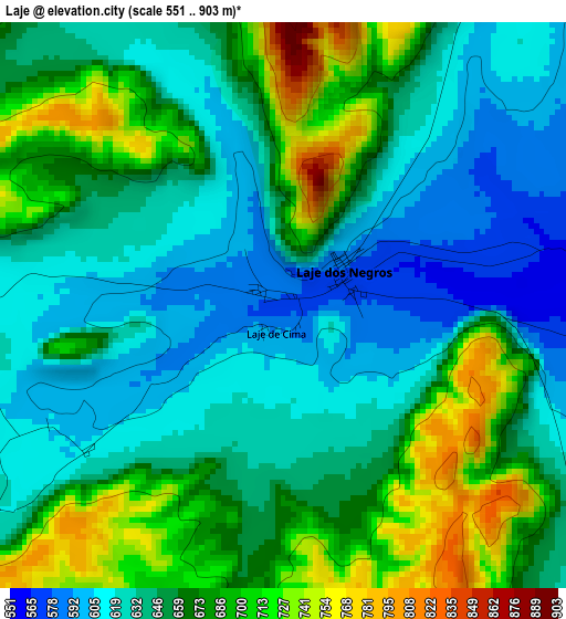
Below is the Elevation map of Laje, which displays elevation range with different colors. Scale of the first map is from 551 to 903 m (1808 to 2963 ft) with average elevation of 655.6 meters (=2151 ft) [note 1]
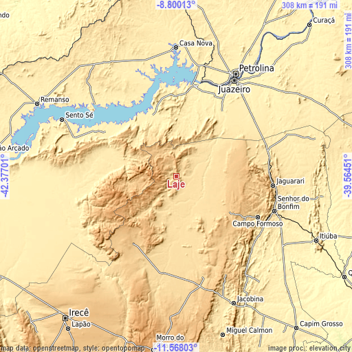
These maps also provides idea of topography and contour of this city, they are displayed at different zoom levels. More info about maps, scale and edge coordinates you can find below images.

| \ | Map #1 | Map #2 | Topo.Map |
| Scale [m] | 551..903 m | 523..969 m | × |
| Scale [ft] | 1808..2963 ft | 1716..3179 ft | × |
| Average | 655.6 m = 2151 ft | 683.9 m = 2244 ft | × |
| Width | 9.62 km = 6 mi | 19.24 km = 12 mi | 307.8 km = 191.3 mi |
| Height | 9.62 km = 6 mi | 19.24 km = 12 mi | 307.8 km = 191.3 mi |
| ↑Max Latitude | -10.143825° | -10.100563° | -8.80013° |
| Latitude at center | -10.18708° | -10.18708° | -10.18708° |
| ↓Min Latitude | -10.23033° | -10.273573° | -11.56803° |
| ← Min Longitude | -41.014705° | -41.058651° | -42.37701° |
| Longitude center | -40.97076° | -40.97076° | -40.97076° |
| →Max Longitude | -40.926815° | -40.882869° | -39.56451° |
Nearby cities:
Cities around Laje sort by population:
• Petrolina elevation 383 m
101.7 km,  30°
30°
• Irecê 730 m
157.4 km,  217°
217°
• Senhor do Bonfim 544 m
90.7 km,  109°
109°
• Jacobina 476 m
121.3 km,  155°
155°
• Campo Formoso 580 m
79.5 km,  116°
116°
• Jaguarari 660 m
85.2 km,  95°
95°
• Morro do Chapéu 1019 m
152.8 km,  187°
187°
• Pindobaçu 435 m
90.8 km,  132°
132°
• América Dourada 665 m
149.9 km,  199°
199°
• Miguel Calmon 543 m
144 km, 163°
• Lapão 775 m
162.9 km, 215°
• Ponto Novo 370 m
118.4 km, 129°
Multilingual:
 En español:
Laje elevación 576 m.
 En France:
Laje élévation 576 m.


Sources and notes:
- [note 1] Map square and city borders are not equal. Map elevation data is calculated only from area inside that square.
- [src 1] Elevation data from geonames database provided with same terms of usage.
- [src 2] The elevation map of Laje is generated using elevation data from NASA's 3 arcsec (90m) resolution SRTM data.
- [src 3] Base (background) map © OpenStreetMap contributors tiles are generated by Geofabrik and OpenTopoMap.
Copyright & License:
This Laje Elevation Map is licensed under CC BY-SA. You may reuse any part from this page, if you give a proper credit by linking to this URL:
 More info on terms of use page.