Matozinhos elevation
Matozinhos (Minas Gerais), Brazil elevation is 814 meters and Matozinhos elevation in feet is 2671 ft above sea level [src 1]. Matozinhos is a populated place (feature code) with elevation that is 432 meters (1417 ft) bigger than average city elevation in Brazil.
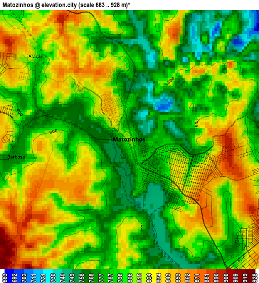
Below is the Elevation map of Matozinhos, which displays elevation range with different colors. Scale of the first map is from 683 to 928 m (2241 to 3045 ft) with average elevation of 805.9 meters (=2644 ft) [note 1]
These maps also provides idea of topography and contour of this city, they are displayed at different zoom levels. More info about maps, scale and edge coordinates you can find below images.
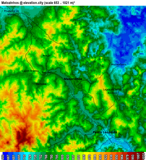
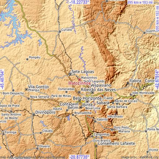
| \ | Map #1 | Map #2 | Topo.Map |
| Scale [m] | 683..928 m | 653..1021 m | × |
| Scale [ft] | 2241..3045 ft | 2142..3350 ft | × |
| Average | 805.9 m = 2644 ft | 801 m = 2628 ft | × |
| Width | 9.21 km = 5.7 mi | 18.42 km = 11.4 mi | 294.7 km = 183.1 mi |
| Height | 9.21 km = 5.7 mi | 18.42 km = 11.4 mi | 294.7 km = 183.1 mi |
| ↑Max Latitude | -19.516365° | -19.474939° | -18.22733° |
| Latitude at center | -19.55778° | -19.55778° | -19.55778° |
| ↓Min Latitude | -19.599185° | -19.640578° | -20.87735° |
| ← Min Longitude | -44.125335° | -44.169281° | -45.48764° |
| Longitude center | -44.08139° | -44.08139° | -44.08139° |
| →Max Longitude | -44.037445° | -43.993499° | -42.67514° |
Nearby cities:
Cities around Matozinhos sort by population:
• Belo Horizonte elevation 872 m
43.1 km,  159°
159°
• Contagem 945 m
41.7 km,  175°
175°
• Ribeirão das Neves 804 m
23.3 km, 181°
• Betim 834 m
47.2 km,  195°
195°
• Santa Luzia 760 m
33.7 km,  134°
134°
• Sete Lagoas 764 m
20.1 km,  300°
300°
• Ibirité 883 m
51.7 km, 177°
• Esmeraldas 755 m
33.3 km,  226°
226°
• Vespasiano 689 m
22.3 km, 132°
• Pedro Leopoldo 714 m
7.8 km,  149°
149°
• Lagoa Santa 791 m
20.5 km,  113°
113°
• Juatuba 720 m
51.7 km,  211°
211°
Multilingual:
 En español:
Matozinhos elevación 814 m.
 En France:
Matozinhos élévation 814 m.
 Auf Deutsch:
Matozinhos höhe über dem Meeresspiegel ist 814 m.

Sources and notes:
- [note 1] Map square and city borders are not equal. Map elevation data is calculated only from area inside that square.
- [src 1] Elevation data from geonames database provided with same terms of usage.
- [src 2] The elevation map of Matozinhos is generated using elevation data from NASA's 3 arcsec (90m) resolution SRTM data.
- [src 3] Base (background) map © OpenStreetMap contributors tiles are generated by Geofabrik and OpenTopoMap.
Copyright & License:
This Matozinhos Elevation Map is licensed under CC BY-SA. You may reuse any part from this page, if you give a proper credit by linking to this URL:
 More info on terms of use page.