Palhoça elevation
Palhoça (Santa Catarina), Brazil elevation is 5 meters and Palhoça elevation in feet is 16 ft above sea level [src 1]. Palhoça is a seat of a second-order administrative division (feature code) with elevation that is 377 meters (1237 ft) smaller than average city elevation in Brazil.
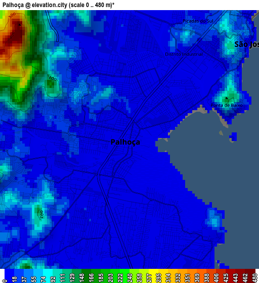
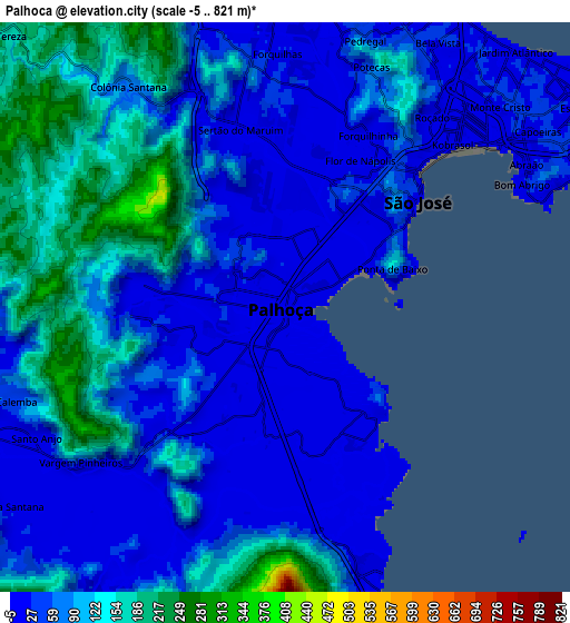
Below is the Elevation map of Palhoça, which displays elevation range with different colors. Scale of the first map is from 0 to 480 m (0 to 1575 ft) with average elevation of 34.6 meters (=114 ft) [note 1]
These maps also provides idea of topography and contour of this city, they are displayed at different zoom levels. More info about maps, scale and edge coordinates you can find below images.
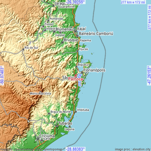
| \ | Map #1 | Map #2 | Topo.Map |
| Scale [m] | 0..480 m | -5..821 m | × |
| Scale [ft] | 0..1575 ft | -16..2694 ft | × |
| Average | 34.6 m = 114 ft | 75 m = 246 ft | × |
| Width | 8.66 km = 5.4 mi | 17.31 km = 10.8 mi | 277 km = 172.1 mi |
| Height | 8.66 km = 5.4 mi | 17.31 km = 10.8 mi | 277 km = 172.1 mi |
| ↑Max Latitude | -27.606345° | -27.567396° | -26.39255° |
| Latitude at center | -27.64528° | -27.64528° | -27.64528° |
| ↓Min Latitude | -27.684201° | -27.723109° | -28.88383° |
| ← Min Longitude | -48.711725° | -48.755671° | -50.07403° |
| Longitude center | -48.66778° | -48.66778° | -48.66778° |
| →Max Longitude | -48.623835° | -48.579889° | -47.26153° |
Nearby cities:
Cities around Palhoça sort by population:
• Florianópolis elevation 26 m
12.9 km,  65°
65°
• Ribeirão da Ilha 9 m
14.6 km,  114°
114°
• Freguesia do Ribeirao da Ilha 13 m
13.1 km,  127°
127°
• Campinas 8 m
8.2 km,  46°
46°
• Santo Amaro da Imperatriz 29 m
11.9 km,  246°
246°
• Saco dos Limoes 7 m
13.6 km, 72°
• Costeira do Pirajubae 40 m
14.5 km,  85°
85°
• Morro da Cruz 156 m
14.6 km,  62°
62°
• Pantanal 42 m
15.4 km,  75°
75°
• Carianos 5 m
12.4 km,  98°
98°
• Carvoeira 30 m
14.9 km, 69°
• Tapera 4 m
12.3 km, 111°
Multilingual:
 En español:
Palhoça elevación 5 m.
 En France:
Palhoça élévation 5 m.


Sources and notes:
- [note 1] Map square and city borders are not equal. Map elevation data is calculated only from area inside that square.
- [src 1] Elevation data from geonames database provided with same terms of usage.
- [src 2] The elevation map of Palhoça is generated using elevation data from NASA's 3 arcsec (90m) resolution SRTM data.
- [src 3] Base (background) map © OpenStreetMap contributors tiles are generated by Geofabrik and OpenTopoMap.
Copyright & License:
This Palhoça Elevation Map is licensed under CC BY-SA. You may reuse any part from this page, if you give a proper credit by linking to this URL:
 More info on terms of use page.