Pires do Rio elevation
Pires do Rio (Goiás), Brazil elevation is 770 meters and Pires do Rio elevation in feet is 2526 ft above sea level [src 1]. Pires do Rio is a populated place (feature code) with elevation that is 388 meters (1273 ft) bigger than average city elevation in Brazil.
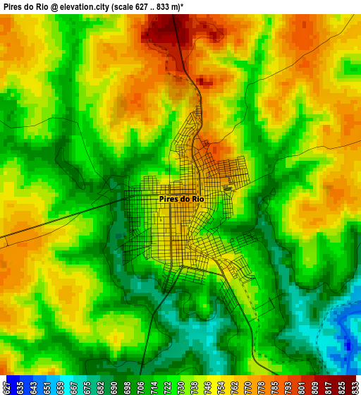
Below is the Elevation map of Pires do Rio, which displays elevation range with different colors. Scale of the first map is from 627 to 833 m (2057 to 2733 ft) with average elevation of 734.1 meters (=2408 ft) [note 1]
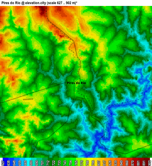
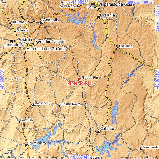
These maps also provides idea of topography and contour of this city, they are displayed at different zoom levels. More info about maps, scale and edge coordinates you can find below images.
| \ | Map #1 | Map #2 | Topo.Map |
| Scale [m] | 627..833 m | 627..902 m | × |
| Scale [ft] | 2057..2733 ft | 2057..2959 ft | × |
| Average | 734.1 m = 2408 ft | 739.8 m = 2427 ft | × |
| Width | 9.33 km = 5.8 mi | 18.66 km = 11.6 mi | 298.5 km = 185.5 mi |
| Height | 9.33 km = 5.8 mi | 18.66 km = 11.6 mi | 298.6 km = 185.5 mi |
| ↑Max Latitude | -17.257758° | -17.215786° | -15.9523° |
| Latitude at center | -17.29972° | -17.29972° | -17.29972° |
| ↓Min Latitude | -17.341673° | -17.383615° | -18.63734° |
| ← Min Longitude | -48.323385° | -48.367331° | -49.68569° |
| Longitude center | -48.27944° | -48.27944° | -48.27944° |
| →Max Longitude | -48.235495° | -48.191549° | -46.87319° |
Nearby cities:
Cities around Pires do Rio sort by population:
• Caldas Novas elevation 695 m
61.7 km,  216°
216°
• Catalão 843 m
102.6 km,  159°
159°
• Senador Canedo 800 m
108.7 km,  307°
307°
• Cristalina 1229 m
92.1 km,  50°
50°
• Morrinhos 751 m
99.3 km,  241°
241°
• Ipameri 773 m
48.6 km, 164°
• Piracanjuba 737 m
78.3 km,  269°
269°
• Bela Vista de Goiás 803 m
80.3 km,  296°
296°
• Silvânia 903 m
79.4 km,  333°
333°
• Vianópolis 1006 m
66.9 km,  337°
337°
• Orizona 810 m
29.9 km,  356°
356°
• Hidrolândia 824 m
107.6 km,  290°
290°
Multilingual:
 En español:
Pires do Rio elevación 770 m.
 En France:
Pires do Rio élévation 770 m.
 Auf Deutsch:
Pires do Rio höhe über dem Meeresspiegel ist 770 m.

Sources and notes:
- [note 1] Map square and city borders are not equal. Map elevation data is calculated only from area inside that square.
- [src 1] Elevation data from geonames database provided with same terms of usage.
- [src 2] The elevation map of Pires do Rio is generated using elevation data from NASA's 3 arcsec (90m) resolution SRTM data.
- [src 3] Base (background) map © OpenStreetMap contributors tiles are generated by Geofabrik and OpenTopoMap.
Copyright & License:
This Pires do Rio Elevation Map is licensed under CC BY-SA. You may reuse any part from this page, if you give a proper credit by linking to this URL:
 More info on terms of use page.