Rio Claro elevation
Rio Claro (Rio de Janeiro), Brazil elevation is 464 meters and Rio Claro elevation in feet is 1522 ft above sea level [src 1]. Rio Claro is a populated place (feature code) with elevation that is 82 meters (269 ft) bigger than average city elevation in Brazil.
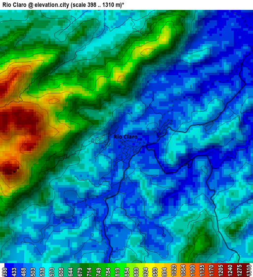
Below is the Elevation map of Rio Claro, which displays elevation range with different colors. Scale of the first map is from 398 to 1310 m (1306 to 4298 ft) with average elevation of 609.3 meters (=1999 ft) [note 1]
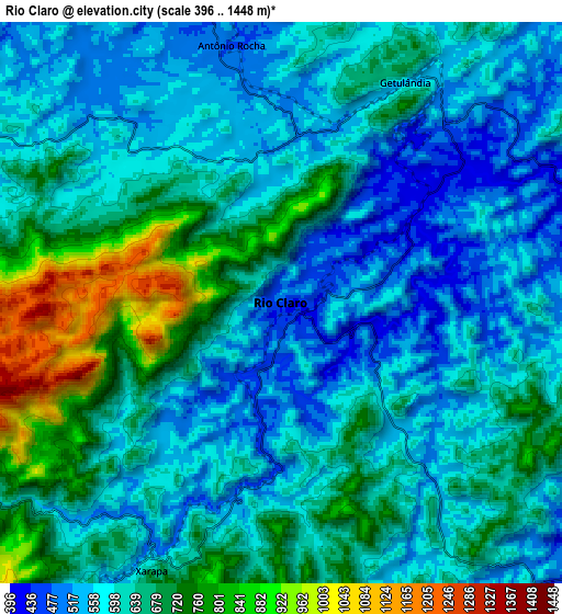
These maps also provides idea of topography and contour of this city, they are displayed at different zoom levels. More info about maps, scale and edge coordinates you can find below images.
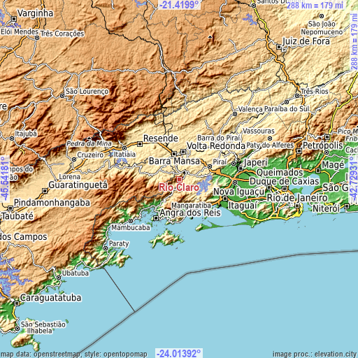
| \ | Map #1 | Map #2 | Topo.Map |
| Scale [m] | 398..1310 m | 396..1448 m | × |
| Scale [ft] | 1306..4298 ft | 1299..4751 ft | × |
| Average | 609.3 m = 1999 ft | 627.2 m = 2058 ft | × |
| Width | 9.01 km = 5.6 mi | 18.03 km = 11.2 mi | 288.4 km = 179.2 mi |
| Height | 9.01 km = 5.6 mi | 18.03 km = 11.2 mi | 288.4 km = 179.2 mi |
| ↑Max Latitude | -22.68252° | -22.641967° | -21.4199° |
| Latitude at center | -22.72306° | -22.72306° | -22.72306° |
| ↓Min Latitude | -22.763588° | -22.804105° | -24.01392° |
| ← Min Longitude | -44.179505° | -44.223451° | -45.54181° |
| Longitude center | -44.13556° | -44.13556° | -44.13556° |
| →Max Longitude | -44.091615° | -44.047669° | -42.72931° |
Nearby cities:
Cities around Rio Claro sort by population:
• Volta Redonda elevation 400 m
22.5 km,  8°
8°
• Barra Mansa 380 m
20.2 km,  349°
349°
• Angra dos Reis 8 m
36.7 km,  210°
210°
• Resende 408 m
42.6 km,  311°
311°
• Itaguaí 31 m
39.6 km,  111°
111°
• Barra do Piraí 366 m
42.5 km,  48°
48°
• Seropédica 40 m
44 km,  93°
93°
• Mangaratiba 21 m
28.1 km,  159°
159°
• Pinheiral 375 m
27.2 km,  30°
30°
• Piraí 381 m
26.5 km,  66°
66°
• Porto Real 392 m
37.3 km,  334°
334°
• Quatis 403 m
37.3 km,  340°
340°
Multilingual:
 En español:
Río Claro elevación 464 m.
 En France:
Rio Claro élévation 464 m.
 Auf Deutsch:
Rio Claro höhe über dem Meeresspiegel ist 464 m.

Sources and notes:
- [note 1] Map square and city borders are not equal. Map elevation data is calculated only from area inside that square.
- [src 1] Elevation data from geonames database provided with same terms of usage.
- [src 2] The elevation map of Rio Claro is generated using elevation data from NASA's 3 arcsec (90m) resolution SRTM data.
- [src 3] Base (background) map © OpenStreetMap contributors tiles are generated by Geofabrik and OpenTopoMap.
Copyright & License:
This Rio Claro Elevation Map is licensed under CC BY-SA. You may reuse any part from this page, if you give a proper credit by linking to this URL:
 More info on terms of use page.