Santos elevation
Santos (São Paulo), Brazil elevation is 12 meters and Santos elevation in feet is 39 ft above sea level [src 1]. Santos is a seat of a second-order administrative division (feature code) with elevation that is 370 meters (1214 ft) smaller than average city elevation in Brazil.
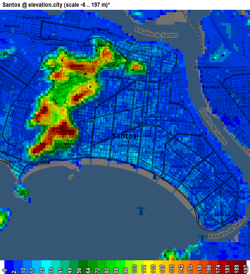
Below is the Elevation map of Santos, which displays elevation range with different colors. Scale of the first map is from -6 to 197 m (-20 to 646 ft) with average elevation of 23.2 meters (=76 ft) [note 1]
These maps also provides idea of topography and contour of this city, they are displayed at different zoom levels. More info about maps, scale and edge coordinates you can find below images.
| \ | Map #1 | Map #2 | Topo.Map |
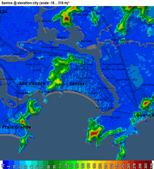
| Scale [m] | -6..197 m | -16..316 m | × |
| Scale [ft] | -20..646 ft | -52..1037 ft | × |
| Average | 23.2 m = 76 ft | 23.3 m = 76 ft | × |
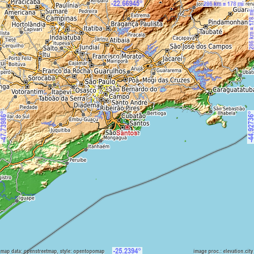
| Width | 8.93 km = 5.5 mi | 17.86 km = 11.1 mi | 285.8 km = 177.6 mi |
| Height | 8.93 km = 5.5 mi | 17.86 km = 11.1 mi | 285.8 km = 177.6 mi |
| ↑Max Latitude | -23.920665° | -23.880489° | -22.66945° |
| Latitude at center | -23.96083° | -23.96083° | -23.96083° |
| ↓Min Latitude | -24.000982° | -24.041121° | -25.2394° |
| ← Min Longitude | -46.377555° | -46.421501° | -47.73986° |
| Longitude center | -46.33361° | -46.33361° | -46.33361° |
| →Max Longitude | -46.289665° | -46.245719° | -44.92736° |
Nearby cities:
Cities around Santos sort by population:
• São Bernardo do Campo elevation 796 m
37.9 km,  321°
321°
• Santo André 801 m
39 km,  327°
327°
• Diadema 784 m
42.4 km, 316°
• Mauá 773 m
35.1 km,  338°
338°
• São Vicente 10 m
5.9 km,  267°
267°
• Guarujá 13 m
8.6 km,  114°
114°
• Praia Grande 11 m
8.6 km,  234°
234°
• Cubatão 6 m
11.8 km,  308°
308°
• Ribeirão Pires 760 m
29 km, 343°
• Mongaguá 8 m
32.7 km,  243°
243°
• Rio Grande da Serra 777 m
25 km, 344°
• Bertioga 8 m
23.1 km,  59°
59°
Multilingual:
 En español:
Santos elevación 12 m.
 En France:
Santos élévation 12 m.


Sources and notes:
- [note 1] Map square and city borders are not equal. Map elevation data is calculated only from area inside that square.
- [src 1] Elevation data from geonames database provided with same terms of usage.
- [src 2] The elevation map of Santos is generated using elevation data from NASA's 3 arcsec (90m) resolution SRTM data.
- [src 3] Base (background) map © OpenStreetMap contributors tiles are generated by Geofabrik and OpenTopoMap.
Copyright & License:
This Santos Elevation Map is licensed under CC BY-SA. You may reuse any part from this page, if you give a proper credit by linking to this URL:
 More info on terms of use page.