São João Evangelista elevation
São João Evangelista (Minas Gerais), Brazil elevation is 708 meters and São João Evangelista elevation in feet is 2323 ft above sea level [src 1]. São João Evangelista is a populated place (feature code) with elevation that is 326 meters (1070 ft) bigger than average city elevation in Brazil.
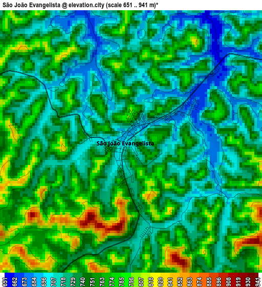
Below is the Elevation map of São João Evangelista, which displays elevation range with different colors. Scale of the first map is from 651 to 941 m (2136 to 3087 ft) with average elevation of 744.1 meters (=2441 ft) [note 1]
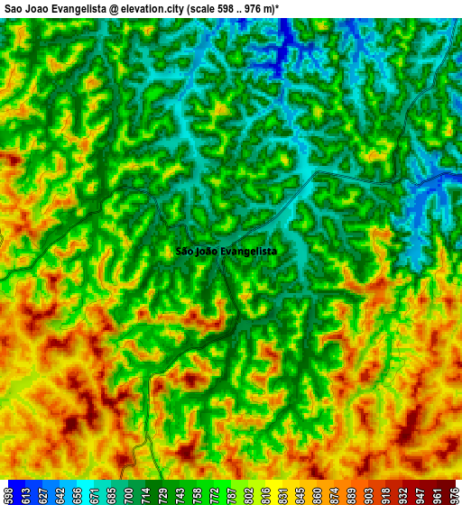
These maps also provides idea of topography and contour of this city, they are displayed at different zoom levels. More info about maps, scale and edge coordinates you can find below images.
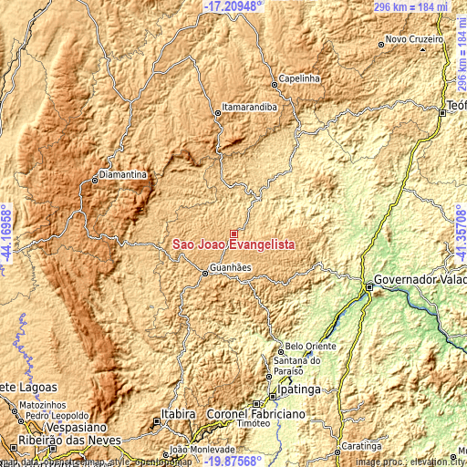
| \ | Map #1 | Map #2 | Topo.Map |
| Scale [m] | 651..941 m | 598..976 m | × |
| Scale [ft] | 2136..3087 ft | 1962..3202 ft | × |
| Average | 744.1 m = 2441 ft | 772.9 m = 2536 ft | × |
| Width | 9.26 km = 5.8 mi | 18.53 km = 11.5 mi | 296.5 km = 184.2 mi |
| Height | 9.26 km = 5.8 mi | 18.53 km = 11.5 mi | 296.5 km = 184.2 mi |
| ↑Max Latitude | -18.506112° | -18.464434° | -17.20948° |
| Latitude at center | -18.54778° | -18.54778° | -18.54778° |
| ↓Min Latitude | -18.589438° | -18.631085° | -19.87568° |
| ← Min Longitude | -42.807275° | -42.851221° | -44.16958° |
| Longitude center | -42.76333° | -42.76333° | -42.76333° |
| →Max Longitude | -42.719385° | -42.675439° | -41.35708° |
Nearby cities:
Cities around São João Evangelista sort by population:
• Governador Valadares elevation 169 m
92.1 km,  111°
111°
• Diamantina 1281 m
94.7 km,  290°
290°
• Santana do Paraíso 566 m
93 km,  167°
167°
• Guanhães 773 m
30.9 km,  215°
215°
• Belo Oriente 261 m
80.3 km,  158°
158°
• Itamarandiba 907 m
77.4 km,  352°
352°
• Açucena 480 m
62.7 km, 158°
• Serro 821 m
65.2 km,  264°
264°
• Conceição do Mato Dentro 708 m
88.4 km,  231°
231°
• Santa Maria do Suaçuí 474 m
54.2 km,  42°
42°
• Sabinópolis 714 m
36.3 km,  248°
248°
• Peçanha 784 m
21.8 km,  90°
90°
Multilingual:
 En español:
São João Evangelista elevación 708 m.
 En France:
São João Evangelista élévation 708 m.
 Auf Deutsch:
São João Evangelista höhe über dem Meeresspiegel ist 708 m.
 На русском:
São João Evangelista высота над уровнем моря 708 м
Sources and notes:
- [note 1] Map square and city borders are not equal. Map elevation data is calculated only from area inside that square.
- [src 1] Elevation data from geonames database provided with same terms of usage.
- [src 2] The elevation map of São João Evangelista is generated using elevation data from NASA's 3 arcsec (90m) resolution SRTM data.
- [src 3] Base (background) map © OpenStreetMap contributors tiles are generated by Geofabrik and OpenTopoMap.
Copyright & License:
This São João Evangelista Elevation Map is licensed under CC BY-SA. You may reuse any part from this page, if you give a proper credit by linking to this URL:
 More info on terms of use page.