Severínia elevation
Severínia (São Paulo), Brazil elevation is 588 meters and Severínia elevation in feet is 1929 ft above sea level [src 1]. Severínia is a populated place (feature code) with elevation that is 206 meters (676 ft) bigger than average city elevation in Brazil.
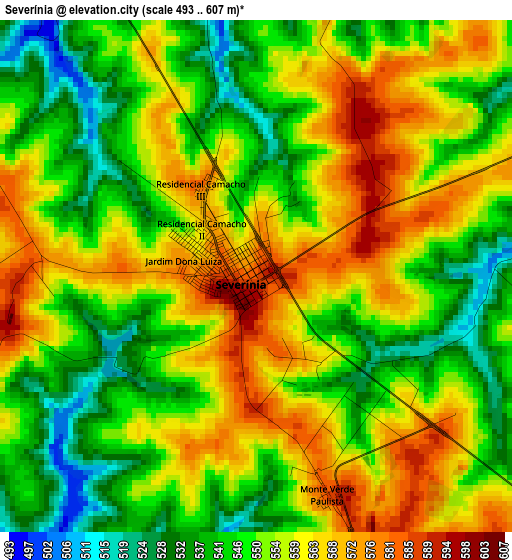
Below is the Elevation map of Severínia, which displays elevation range with different colors. Scale of the first map is from 493 to 607 m (1617 to 1991 ft) with average elevation of 553.6 meters (=1816 ft) [note 1]
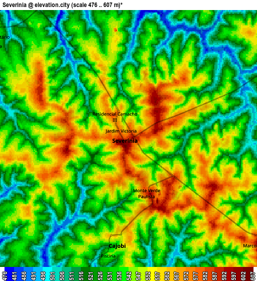
These maps also provides idea of topography and contour of this city, they are displayed at different zoom levels. More info about maps, scale and edge coordinates you can find below images.
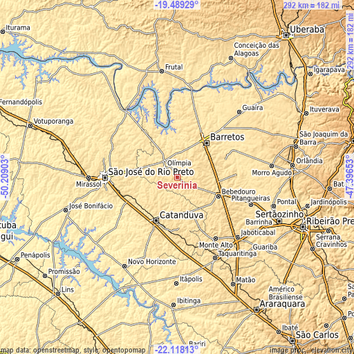
| \ | Map #1 | Map #2 | Topo.Map |
| Scale [m] | 493..607 m | 476..607 m | × |
| Scale [ft] | 1617..1991 ft | 1562..1991 ft | × |
| Average | 553.6 m = 1816 ft | 538.1 m = 1765 ft | × |
| Width | 9.13 km = 5.7 mi | 18.27 km = 11.4 mi | 292.3 km = 181.6 mi |
| Height | 9.14 km = 5.7 mi | 18.27 km = 11.4 mi | 292.3 km = 181.6 mi |
| ↑Max Latitude | -20.768356° | -20.72726° | -19.48929° |
| Latitude at center | -20.80944° | -20.80944° | -20.80944° |
| ↓Min Latitude | -20.850513° | -20.891575° | -22.11813° |
| ← Min Longitude | -48.846725° | -48.890671° | -50.20903° |
| Longitude center | -48.80278° | -48.80278° | -48.80278° |
| →Max Longitude | -48.758835° | -48.714889° | -47.39653° |
Nearby cities:
Cities around Severínia sort by population:
• São José do Rio Preto elevation 505 m
59.9 km,  268°
268°
• Catanduva 517 m
40.6 km,  205°
205°
• Barretos 538 m
37.2 km,  41°
41°
• Bebedouro 574 m
37 km,  114°
114°
• Olímpia 520 m
14.1 km,  304°
304°
• Monte Alto 723 m
59.4 km,  147°
147°
• Monte Azul Paulista 615 m
20 km,  122°
122°
• Viradouro 540 m
53 km,  97°
97°
• Guapiaçu 508 m
43.4 km, 272°
• Santa Adélia 617 m
48.2 km,  180°
180°
• Pindorama 530 m
43.2 km,  194°
194°
• Paraíso 581 m
23.2 km,  172°
172°
Multilingual:
 En español:
Severínia elevación 588 m.
 En France:
Severínia élévation 588 m.
 Auf Deutsch:
Severínia höhe über dem Meeresspiegel ist 588 m.

Sources and notes:
- [note 1] Map square and city borders are not equal. Map elevation data is calculated only from area inside that square.
- [src 1] Elevation data from geonames database provided with same terms of usage.
- [src 2] The elevation map of Severínia is generated using elevation data from NASA's 3 arcsec (90m) resolution SRTM data.
- [src 3] Base (background) map © OpenStreetMap contributors tiles are generated by Geofabrik and OpenTopoMap.
Copyright & License:
This Severínia Elevation Map is licensed under CC BY-SA. You may reuse any part from this page, if you give a proper credit by linking to this URL:
 More info on terms of use page.