Telêmaco Borba elevation
Telêmaco Borba (Paraná), Brazil elevation is 736 meters and Telêmaco Borba elevation in feet is 2415 ft above sea level [src 1]. Telêmaco Borba is a populated place (feature code) with elevation that is 354 meters (1161 ft) bigger than average city elevation in Brazil.
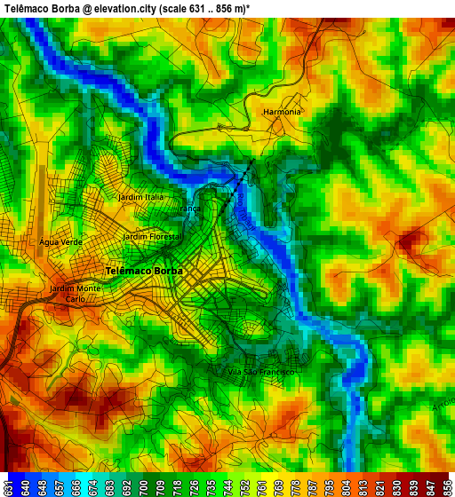
Below is the Elevation map of Telêmaco Borba, which displays elevation range with different colors. Scale of the first map is from 631 to 856 m (2070 to 2808 ft) with average elevation of 745.9 meters (=2447 ft) [note 1]
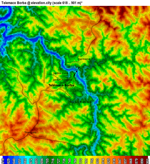
These maps also provides idea of topography and contour of this city, they are displayed at different zoom levels. More info about maps, scale and edge coordinates you can find below images.
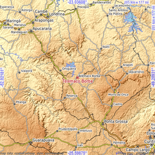
| \ | Map #1 | Map #2 | Topo.Map |
| Scale [m] | 631..856 m | 618..901 m | × |
| Scale [ft] | 2070..2808 ft | 2028..2956 ft | × |
| Average | 745.9 m = 2447 ft | 767.6 m = 2518 ft | × |
| Width | 8.9 km = 5.5 mi | 17.81 km = 11.1 mi | 284.9 km = 177 mi |
| Height | 8.91 km = 5.5 mi | 17.81 km = 11.1 mi | 285 km = 177.1 mi |
| ↑Max Latitude | -24.283839° | -24.243776° | -23.03608° |
| Latitude at center | -24.32389° | -24.32389° | -24.32389° |
| ↓Min Latitude | -24.363928° | -24.403953° | -25.59875° |
| ← Min Longitude | -50.659505° | -50.703451° | -52.02181° |
| Longitude center | -50.61556° | -50.61556° | -50.61556° |
| →Max Longitude | -50.571615° | -50.527669° | -49.20931° |
Nearby cities:
Cities around Telêmaco Borba sort by population:
• Castro elevation 986 m
80 km,  130°
130°
• Jaguariaíva 875 m
92.3 km,  84°
84°
• Ibaiti 842 m
68.4 km,  39°
39°
• Piraí do Sul 1000 m
71.2 km,  108°
108°
• Wenceslau Braz 834 m
96.5 km,  58°
58°
• Carambeí 1053 m
86.2 km,  144°
144°
• Faxinal 832 m
80 km,  296°
296°
• Tibagi 716 m
29 km, 135°
• Ortigueira 772 m
36.2 km,  290°
290°
• Reserva 943 m
43.4 km,  213°
213°
• Terra Roxa 688 m
78.9 km,  48°
48°
• Cândido de Abreu 541 m
77.5 km,  249°
249°
Multilingual:
 En español:
Telêmaco Borba elevación 736 m.
 En France:
Telêmaco Borba élévation 736 m.
 Auf Deutsch:
Telêmaco Borba höhe über dem Meeresspiegel ist 736 m.

Sources and notes:
- [note 1] Map square and city borders are not equal. Map elevation data is calculated only from area inside that square.
- [src 1] Elevation data from geonames database provided with same terms of usage.
- [src 2] The elevation map of Telêmaco Borba is generated using elevation data from NASA's 3 arcsec (90m) resolution SRTM data.
- [src 3] Base (background) map © OpenStreetMap contributors tiles are generated by Geofabrik and OpenTopoMap.
Copyright & License:
This Telêmaco Borba Elevation Map is licensed under CC BY-SA. You may reuse any part from this page, if you give a proper credit by linking to this URL:
 More info on terms of use page.