Várzea da Palma elevation
Várzea da Palma (Minas Gerais), Brazil elevation is 523 meters and Várzea da Palma elevation in feet is 1716 ft above sea level [src 1]. Várzea da Palma is a populated place (feature code) with elevation that is 141 meters (463 ft) bigger than average city elevation in Brazil.
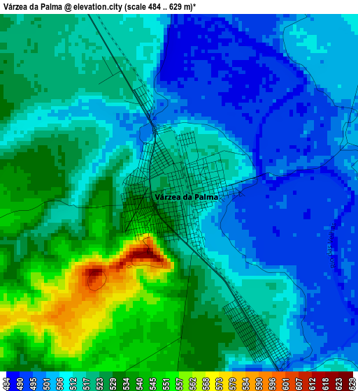
Below is the Elevation map of Várzea da Palma, which displays elevation range with different colors. Scale of the first map is from 484 to 629 m (1588 to 2064 ft) with average elevation of 517.8 meters (=1699 ft) [note 1]
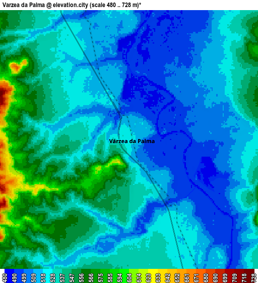
These maps also provides idea of topography and contour of this city, they are displayed at different zoom levels. More info about maps, scale and edge coordinates you can find below images.
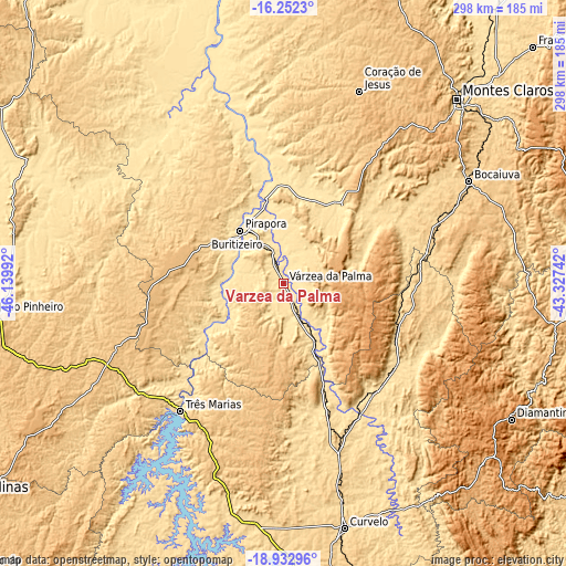
| \ | Map #1 | Map #2 | Topo.Map |
| Scale [m] | 484..629 m | 480..728 m | × |
| Scale [ft] | 1588..2064 ft | 1575..2388 ft | × |
| Average | 517.8 m = 1699 ft | 527.6 m = 1731 ft | × |
| Width | 9.32 km = 5.8 mi | 18.63 km = 11.6 mi | 298.1 km = 185.2 mi |
| Height | 9.32 km = 5.8 mi | 18.63 km = 11.6 mi | 298.1 km = 185.2 mi |
| ↑Max Latitude | -17.555706° | -17.513803° | -16.2523° |
| Latitude at center | -17.5976° | -17.5976° | -17.5976° |
| ↓Min Latitude | -17.639484° | -17.681358° | -18.93296° |
| ← Min Longitude | -44.777615° | -44.821561° | -46.13992° |
| Longitude center | -44.73367° | -44.73367° | -44.73367° |
| →Max Longitude | -44.689725° | -44.645779° | -43.32742° |
Nearby cities:
Cities around Várzea da Palma sort by population:
• Montes Claros elevation 686 m
133.3 km,  44°
44°
• Curvelo 653 m
132.8 km,  166°
166°
• Pirapora 502 m
35.7 km,  321°
321°
• Diamantina 1281 m
139.7 km,  121°
121°
• Bocaiúva 683 m
111.7 km,  60°
60°
• João Pinheiro 775 m
153.3 km,  263°
263°
• Buritizeiro 516 m
36.6 km, 318°
• Corinto 649 m
91.9 km,  161°
161°
• Brasília de Minas 728 m
158 km,  11°
11°
• Serro 821 m
181.7 km,  128°
128°
• Coração de Jesus 769 m
108.7 km,  21°
21°
• Mirabela 801 m
160.3 km, 22°
Multilingual:
 En español:
Várzea da Palma elevación 523 m.
 En France:
Várzea da Palma élévation 523 m.
 Auf Deutsch:
Várzea da Palma höhe über dem Meeresspiegel ist 523 m.

Sources and notes:
- [note 1] Map square and city borders are not equal. Map elevation data is calculated only from area inside that square.
- [src 1] Elevation data from geonames database provided with same terms of usage.
- [src 2] The elevation map of Várzea da Palma is generated using elevation data from NASA's 3 arcsec (90m) resolution SRTM data.
- [src 3] Base (background) map © OpenStreetMap contributors tiles are generated by Geofabrik and OpenTopoMap.
Copyright & License:
This Várzea da Palma Elevation Map is licensed under CC BY-SA. You may reuse any part from this page, if you give a proper credit by linking to this URL:
 More info on terms of use page.