Batalha elevation
Batalha (Alagoas), Brazil elevation is 120 meters and Batalha elevation in feet is 394 ft above sea level [src 1]. Batalha is a populated place (feature code) with elevation that is 262 meters (860 ft) smaller than average city elevation in Brazil.
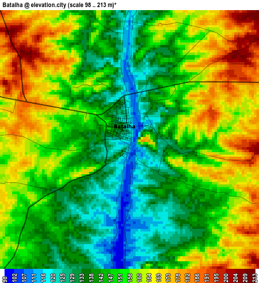
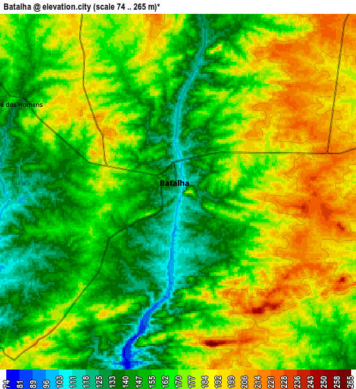
Below is the Elevation map of Batalha, which displays elevation range with different colors. Scale of the first map is from 98 to 213 m (322 to 699 ft) with average elevation of 151.2 meters (=496 ft) [note 1]
These maps also provides idea of topography and contour of this city, they are displayed at different zoom levels. More info about maps, scale and edge coordinates you can find below images.
| \ | Map #1 | Map #2 | Topo.Map |
| Scale [m] | 98..213 m | 74..265 m | × |
| Scale [ft] | 322..699 ft | 243..869 ft | × |
| Average | 151.2 m = 496 ft | 166.4 m = 546 ft | × |
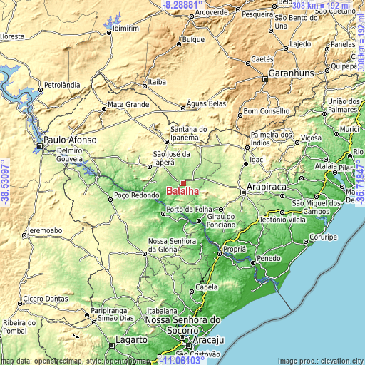
| Width | 9.63 km = 6 mi | 19.27 km = 12 mi | 308.2 km = 191.5 mi |
| Height | 9.63 km = 6 mi | 19.27 km = 12 mi | 308.3 km = 191.6 mi |
| ↑Max Latitude | -9.634457° | -9.591129° | -8.28881° |
| Latitude at center | -9.67778° | -9.67778° | -9.67778° |
| ↓Min Latitude | -9.721097° | -9.764409° | -11.06103° |
| ← Min Longitude | -37.168665° | -37.212611° | -38.53097° |
| Longitude center | -37.12472° | -37.12472° | -37.12472° |
| →Max Longitude | -37.080775° | -37.036829° | -35.71847° |
Nearby cities:
Cities around Batalha sort by population:
• Santana do Ipanema elevation 240 m
35.8 km,  338°
338°
• São José da Tapera 252 m
31.1 km,  295°
295°
• Pão de Açúcar 23 m
35.1 km,  257°
257°
• Girau do Ponciano 248 m
39.7 km,  125°
125°
• Porto da Folha 42 m
31.5 km,  212°
212°
• Major Isidoro 191 m
22.3 km,  43°
43°
• Traipu 30 m
35.2 km,  157°
157°
• Cacimbinhas 262 m
34.2 km,  25°
25°
• Dois Riachos 238 m
31.8 km,  4°
4°
• Gararu 17 m
32.5 km,  171°
171°
• Olivença 226 m
19.1 km, 337°
• Poço das Trincheiras 292 m
44.3 km, 336°
Multilingual:
 En español:
Batalha elevación 120 m.
 En France:
Batalha élévation 120 m.


Sources and notes:
- [note 1] Map square and city borders are not equal. Map elevation data is calculated only from area inside that square.
- [src 1] Elevation data from geonames database provided with same terms of usage.
- [src 2] The elevation map of Batalha is generated using elevation data from NASA's 3 arcsec (90m) resolution SRTM data.
- [src 3] Base (background) map © OpenStreetMap contributors tiles are generated by Geofabrik and OpenTopoMap.
Copyright & License:
This Batalha Elevation Map is licensed under CC BY-SA. You may reuse any part from this page, if you give a proper credit by linking to this URL:
 More info on terms of use page.